shape
carat
color
clarity

Atlantic Hurricane Season in full swing - Please check in folks!

Arcadian

Ideal_Rock
Premium
Joined
Sep 17, 2008
Messages
9,091
For extreme SE Florida this is going to be gusty winds/rain event. Doubtful if its even close to TS type stuff and according to forecasts we'll get more wrap around wind/rain bands. Other parts will feel the effects as it goes up the peninsula.

I will say I have a massive headache because of this.
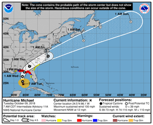

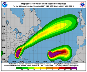
093811_5day_cone_no_line_and_wind.png

SUMMARY OF 700 AM CDT...1200 UTC...INFORMATION
----------------------------------------------
LOCATION...24.5N 86.1W
ABOUT 395 MI...635 KM S OF PANAMA CITY FLORIDA
ABOUT 365 MI...590 KM S OF APALACHICOLA FLORIDA
MAXIMUM SUSTAINED WINDS...100 MPH...155 KM/H
PRESENT MOVEMENT...NNW OR 345 DEGREES AT 12 MPH...19 KM/H
MINIMUM CENTRAL PRESSURE...968 MB...28.58 INCHES
 

Arcadian

Ideal_Rock
Premium
Joined
Sep 17, 2008
Messages
9,091
Michael is now a Cat3 hurricane. Those in the path have hopefully made their preparations.
 

Arcadian

Ideal_Rock
Premium
Joined
Sep 17, 2008
Messages
9,091
Michael is now a Cat 4 and will likely land as that. my goodness this is going to be bad :(

000
WTNT34 KNHC 100848
TCPAT4

BULLETIN
Hurricane Michael Advisory Number 15
NWS National Hurricane Center Miami FL AL142018
400 AM CDT Wed Oct 10 2018

...EXTREMELY DANGEROUS CATEGORY 4 MICHAEL STRENGTHENS
FURTHER AS IT HEADS NORTHWARD TOWARD THE FLORIDA PANHANDLE...
...LIFE-THREATENING STORM SURGE...HURRICANE FORCE WINDS...AND HEAVY
RAINFALL EXPECTED ALONG THE NORTHEASTERN GULF COAST...


SUMMARY OF 400 AM CDT...0900 UTC...INFORMATION
----------------------------------------------
LOCATION...28.3N 86.5W
ABOUT 140 MI...225 KM SSW OF PANAMA CITY FLORIDA
ABOUT 130 MI...215 KM SW OF APALACHICOLA FLORIDA
MAXIMUM SUSTAINED WINDS...140 MPH...220 KM/H
PRESENT MOVEMENT...N OR 360 DEGREES AT 13 MPH...20 KM/H
MINIMUM CENTRAL PRESSURE...943 MB...27.85 INCHES
 

missy

Super_Ideal_Rock
Premium
Joined
Jun 8, 2008
Messages
54,177
Michael is now a Cat 4 and will likely land as that. my goodness this is going to be bad :(

Ugh, sending good thoughts your way and hoping the hurricane dissipates and loses strength. Stay away Michael!!!
 

ohsomethingshiny

Brilliant_Rock
Premium
Joined
Jun 4, 2018
Messages
713
Just checking in. We are on the NE side of the state (near Jacksonville) and out of the path this time. Prayers for those in the panhandle and in the path of this monster.
 

stracci2000

Ideal_Rock
Premium
Joined
Jun 26, 2007
Messages
8,428
Oh no! We are flying into Ft. Myers on Thursday.
I don't know what to expect, and my tickets are non-refundable.
 

Arcadian

Ideal_Rock
Premium
Joined
Sep 17, 2008
Messages
9,091
Thanks for checking in. Latest news is that its gotten stronger, still a cat 4 but oh my goodness, this is heartbreaking. They've also said that Georgia should worry because it will reach there as possible Cat1. For Georgia, thats a lot.

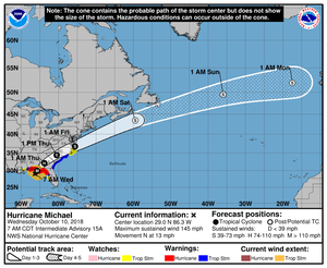
092618.png

I'm hoping that more people check in, especially georgia, louisiana,north/south carolina.


South florida got spared big time by this.
 

Arcadian

Ideal_Rock
Premium
Joined
Sep 17, 2008
Messages
9,091
Oh no! We are flying into Ft. Myers on Thursday.
I don't know what to expect, and my tickets are non-refundable.

Call the airport today. This is an instance they will allow you to reschedule without fee.
 

mary poppins

Ideal_Rock
Premium
Joined
Apr 10, 2010
Messages
2,606
Yikes, this one's a monster! I hope all in its path are able to find a safe place to ride it out.
 

the_mother_thing

Ideal_Rock
Premium
Joined
Mar 2, 2013
Messages
6,307
The weather channel is suggesting this still could become a cat 5 ... even at a 4, it’s catastrophic. Hoping those in the path have sought safe shelter far away from this dangerous, deadly storm. Be safe everyone!
 

Ellen

Super_Ideal_Rock
Joined
Jan 13, 2006
Messages
24,433
Prayers going out to all those possibly affected.
 

Arcadian

Ideal_Rock
Premium
Joined
Sep 17, 2008
Messages
9,091
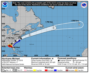
092618_5day_cone_no_line_and_wind.png

The update.
 

whitewave

Super_Ideal_Rock
Premium
Joined
Feb 29, 2012
Messages
12,330
We are definitely feeling tropical conditions in New Orleans since yesterday afternoon.

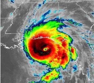
A707345E-6E19-41CC-B6EA-5012CFE78FE8.jpeg
 

the_mother_thing

Ideal_Rock
Premium
Joined
Mar 2, 2013
Messages
6,307
TWC is showing some low-tide storm surge that is already hitting in Alligator Point, FL and rushing up over the bulkhead and docks/piers ... and it isn’t even fully ‘there’ yet. :shock:
 

AGBF

Super_Ideal_Rock
Premium
Joined
Jan 26, 2003
Messages
22,146
Does anyone know which Pricescopers are in the path of Michael? If anyone reading this thinks she is, please let us know now before the hurricane strikes. Prayers and dust outgoing.

AGBF
 

Arcadian

Ideal_Rock
Premium
Joined
Sep 17, 2008
Messages
9,091
Deb I don't know who is, and I'm hoping if they're in direct path they have already left. North/South Carolina is going to get drenched yet again of course, and I've heard there's some areas that still have standing water.

I've talked to folks I work with in GA and they're not in the direct path, but they will get wind/rain tomorrow.
 

Arcadian

Ideal_Rock
Premium
Joined
Sep 17, 2008
Messages
9,091
000
WTNT64 KNHC 101528
TCUAT4

Hurricane Michael Tropical Cyclone Update
NWS National Hurricane Center Miami FL AL142018
1030 AM CDT Wed Oct 10 2018

...MICHAEL STILL STRENGTHENING AS THE EYE NEARS THE COAST OF
THE FLORIDA PANHANDLE...

Data from an Air Force Reserve Hurricane Hunter aircraft indicate
that the maximum sustained winds have increased to near 150 mph

(240 km/h) with higher gusts. The aircraft also reported that the
minimum pressure has fallen to 923 mb (27.26 inches).

The Apalachicola airport recently reported a wind gust of 72 mph
(101 km/h).

Water levels continue to rise quickly along the coast of the Florida
Panhandle. A National Ocean Service water level station at
Apalachicola recently reported over 5 feet of inundation above
ground level.


SUMMARY OF 1030 AM CDT...1530 UTC...INFORMATION
-----------------------------------------------
LOCATION...29.5N 85.9W
ABOUT 50 MI...80 KM SSW OF PANAMA CITY FLORIDA
ABOUT 55 MI...90 KM WSW OF APALACHICOLA FLORIDA
MAXIMUM SUSTAINED WINDS...150 MPH...240 KM/H
PRESENT MOVEMENT...NNE OR 15 DEGREES AT 14 MPH...22 KM/H
MINIMUM CENTRAL PRESSURE...923 MB...27.26 INCHES

$$
Forecaster Brown
 

tyty333

Super_Ideal_Rock
Premium
Joined
Dec 17, 2008
Messages
27,284
Stay safe everyone...this looks like a particularly nasty one :(.
 

mary poppins

Ideal_Rock
Premium
Joined
Apr 10, 2010
Messages
2,606
Hurricane Michael made landfall near Mexico Beach, Florida, on Wednesday afternoon as an intense Category 4 storm — the strongest ever to hit that part of the state in recorded history, with winds gusting at 155 mph. Mexico Beach is a little west of Tallahassee, the state capitol.
 

HS4S_2

Brilliant_Rock
Premium
Joined
May 23, 2017
Messages
1,911
Just checking in. We are on the NE side of the state (near Jacksonville) and out of the path this time. Prayers for those in the panhandle and in the path of this monster.

I am located just South of you We have not even had any rain today. I just received an update that it was 1mph short of a Cat 5 and the pressure is 927 which is consistent with a Cat 5. So scary. Thinking about everyone in the path.
 

Arcadian

Ideal_Rock
Premium
Joined
Sep 17, 2008
Messages
9,091
They're spotting what could be some tornatic activity in northern Florida.
 

Arcadian

Ideal_Rock
Premium
Joined
Sep 17, 2008
Messages
9,091
Now a Cat 3 and moving into Georgia/Alabama
152003_5day_cone_no_line_and_wind.png

Tomorrow it should be more or less TS but going over NC/SC with more rain and wind.
 

yennyfire

Ideal_Rock
Trade
Joined
Jun 6, 2010
Messages
6,873
We are outside of Atlanta and we had a tornado warning for a couple of hours, heavy rain and wind, but nothing too bad.

I’m heartbroken for the folks in FL affected by this. We vacation in Cape San Blas every couple of years and I’m hoping that the area can withstand the storm.

Be safe everyone!
 

diamondseeker2006

Super_Ideal_Rock
Premium
Joined
Jan 11, 2006
Messages
58,547
My sister's husband's family has an oceanfront condo in Panama City Beach, and they are awaiting news of how it fared. They live in SC and are expected to have the storm move toward them after it leaves Yenny's area.

The news said the problem in the Carolina's is that the rivers are still very high after Florence, so if there's enough rain, there will be more flooding. The pictures of the destroyed homes from that hurricane are awful, but it didn't get much news coverage. There was a lot of major damage from flooding.
 

Arcadian

Ideal_Rock
Premium
Joined
Sep 17, 2008
Messages
9,091
@mary poppins there's always some bonehead out there doing stupid stuff. future darwin award nomineeo_O

@yennyfire glad you're doing well. When they said it was going into Georgia I worried how folks would fare there. The energy on this storm was really something else. Thankfully it didn't have more development time.

@diamondseeker2006 Lots of dust that they come away with minimal damage. Those condo's have to be built to withstand at least a 3. However newly built stuff in Florida has to follow Miami-Dade hurricane code. Where I am, even replacement windows/doors have to follow this code (which is for the best!) Keep us in the loop where you are, I'm praying you don't get additional flooding there.
 

diamondseeker2006

Super_Ideal_Rock
Premium
Joined
Jan 11, 2006
Messages
58,547
We were not in the flooding zone last time, thankfully. Most of the very bad flooding was close to the coast. Our schools are closed today due to tropical storm winds and heavy rain. There are so many trees and when the ground is saturated and there is strong wind, there's the likelihood of trees going down.
 

Arcadian

Ideal_Rock
Premium
Joined
Sep 17, 2008
Messages
9,091
I saw some images of Mexico Beach and O.M.G. its gone so much of it has been leveled. Thats a serious do over. I don't see how any building there would be salvagable.
 
Be a part of the community Get 3 HCA Results
Top