shape
carat
color
clarity

Atlantic Hurricane Season in full swing - Please check in folks!

Bonfire

Ideal_Rock
Premium
Joined
Feb 22, 2014
Messages
4,242
Yup...I totally understand why some are stuck and just hope for the best.:wavey:
 

the_mother_thing

Ideal_Rock
Premium
Joined
Mar 2, 2013
Messages
6,307
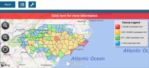
Power outage estimates per Duke Energy:
340B0829-4755-4BFB-90CB-B95EF562732A.png

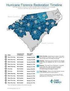
And restoration estimates as of this morning:
45FED208-573D-4655-AEE5-BF7C97E870DE.jpeg

If you live in the area and have Duke, sign up for their text alerts on their website. They are really helpful in the event of an outage.

Also, for those who may be planning any road travel through N.C., the governor has asked travelers to detour around the state by going thru TN instead, as parts of I-95 & I-40 are closed as well as many state routes and rural roads are washed out, flooded, etc. I believe the northern part of I-95 in S.C. is now closed as well.
 

the_mother_thing

Ideal_Rock
Premium
Joined
Mar 2, 2013
Messages
6,307
@Jimmianne Here is a list of some impacts and status of services around the Triangle by town/area, if it’s of any help while you are away: https://abc11.com/weather/curfews-b...what-you-need-to-know-after-florence/4247045/

There is an impressive staging area with thousands of power restoration workers & trucks in SE Raleigh from all over the country as well as Quebec who are being dispatched around the state. Unfortunately, the road closures are preventing them from getting to some of the most severely impacted areas, which is also the case for getting other much needed resources to those areas. Not sure what they can do except to maybe perform aerial drops by helicopter.
 

the_mother_thing

Ideal_Rock
Premium
Joined
Mar 2, 2013
Messages
6,307
@Jimmianne & other ‘locals’: another resource to check if you are worried about flooding in your immediate area - especially if you evacuated or cannot check on your home - is https://fiman.nc.gov/fiman/ This site gives you real-time flooding information of nearby water ways that may affect your area, whether levels are rising or falling, etc.
 

diamondseeker2006

Super_Ideal_Rock
Premium
Joined
Jan 11, 2006
Messages
58,547
I am very happy to say that our rain was gone by this morning, and other than some scattered power outages and minor flooding, our region had minimal issues due to the hurricane. Obviously there is devastation near the coast as they had hurricane strength winds as well as massive flooding due to the huge amount of rain from the slow moving storm. My friend who stayed in Wilmington due to her parents staying posted on FB that they were all okay. It could have been sooo much worse if it hadn’t dropped to category 2 from 4. Very thankful for that! Thanks for all the concern and prayers for the Carolinas!
 

AGBF

Super_Ideal_Rock
Premium
Joined
Jan 26, 2003
Messages
22,146
I am very happy to say that our rain was gone by this morning, and other than some scattered power outages and minor flooding, our region had minimal issues due to the hurricane. Obviously there is devastation near the coast as they had hurricane strength winds as well as massive flooding due to the huge amount of rain from the slow moving storm. My friend who stayed in Wilmington due to her parents staying posted on FB that they were all okay. It could have been sooo much worse if it hadn’t dropped to category 2 from 4. Very thankful for that! Thanks for all the concern and prayers for the Carolinas!

I am so glad to hear your news. I have been concerned about you.

Deb/AGBF
 

autumngems

Ideal_Rock
Premium
Joined
Jul 24, 2003
Messages
2,601
We evacuated to Ohio as we live right by Morehead City,NC. We hope to go back tomorrow as flooding in my road is down enough to get back to my neighborhood. We parked our other cars on the base and know they have some damage. I dont look forward to seeing the devastation. sad :((
 

autumngems

Ideal_Rock
Premium
Joined
Jul 24, 2003
Messages
2,601

OreoRosies86

Ideal_Rock
Premium
Joined
Dec 25, 2012
Messages
3,465
I watched a video my friend sent of the hurricane and the tornadoes that followed :eek2:
 

Arcadian

Ideal_Rock
Premium
Joined
Sep 17, 2008
Messages
9,089

Thank you for telling us about Red Cross. My goodness..... :eek2:

I really don't like donating to RC and prefer for many reasons donate to causes that are local
 

Arcadian

Ideal_Rock
Premium
Joined
Sep 17, 2008
Messages
9,089
I'm back to keeping watch. There are now 4 spots 2 of them of decent concern.

09212018two_atl_0d0.png

Its not over yet until usually end of October.
 

Arcadian

Ideal_Rock
Premium
Joined
Sep 17, 2008
Messages
9,089
BTW, those who are in the NC/SC area is it possible to keep this thread up to date with whats happening there? We don't really get to hear a heck of a lot these days now that the hurricane has passed, but from experience I know how much goes on after the fact.
 

Arcadian

Ideal_Rock
Premium
Joined
Sep 17, 2008
Messages
9,089
North and South Carolina, you guys are not going to be getting a break They're saying this could turn out to be a Tropical Depression but still means more raion for you.
09262018two_atl_0d0.png


And hello, Captn Kirk reformed.
 

Arcadian

Ideal_Rock
Premium
Joined
Sep 17, 2008
Messages
9,089

AGBF

Super_Ideal_Rock
Premium
Joined
Jan 26, 2003
Messages
22,146
Driving home to Connecticut from Virginia I ran into a group of men wearing Fema vests and badges in the line at a Dunkin Donuts at a rest stop. I turned to one of them near me and said, "You really are the good guys. Are you all going somewhere together?" They said they were on their way home from South Carolina. They had been there for weeks. They said they were not in "the worst part", but they didn't appear to have been living in luxury for the past weeks. I asked where they were from and it was from a couple of places, mainly Pennsylvania. They wouldn't let me buy them anything. Heroes.

AGBF
 

whitewave

Super_Ideal_Rock
Premium
Joined
Feb 29, 2012
Messages
12,331
It looks like as long as this new one goes east that we will be in the clear.
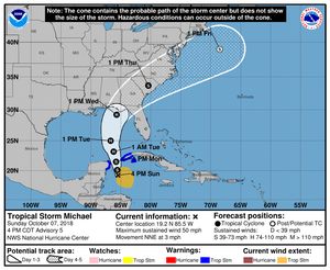
 

Arcadian

Ideal_Rock
Premium
Joined
Sep 17, 2008
Messages
9,089
It looks like as long as this new one goes east that we will be in the clear.
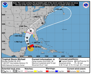
the updated report:
000
WTNT64 KNHC 071653
TCUAT4

Tropical Storm Michael Tropical Cyclone Update
NWS National Hurricane Center Miami FL AL142018
1155 AM CDT Sun Oct 07 2018

...DEPRESSION STRENGTHENS TO A TROPICAL STORM...

Satellite wind data indicate that the depression has strengthened
into Tropical Storm Michael. The maximum winds are estimated to be
40 mph (65 km/h) with higher gusts. An Air Force Reserve Hurricane
Hunter aircraft is currently en route to investigate Michael.


SUMMARY OF 1155 AM CDT...1655 UTC...INFORMATION
-----------------------------------------------
LOCATION...19.2N 86.9W
ABOUT 90 MI...145 KM S OF COZUMEL MEXICO
ABOUT 225 MI...365 KM SW OF THE WESTERN TIP OF CUBA
MAXIMUM SUSTAINED WINDS...40 MPH...65 KM/H
PRESENT MOVEMENT...N OR 360 DEGREES AT 5 MPH...7 KM/H
MINIMUM CENTRAL PRESSURE...1004 MB...29.65 INCHES

$$
Forecaster Brown
 

Arcadian

Ideal_Rock
Premium
Joined
Sep 17, 2008
Messages
9,089
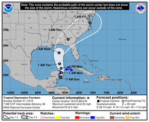
So we've got a bit of a westerly jog and turning into a hurricane by Tuesday. I still think it could go just about anywhere after monday since it will then be in the gulf.
210232_5day_cone_no_line_and_wind.png

The current forecast. (I won't post the 10pm one unless its significantly different)
000
WTNT34 KNHC 072100
TCPAT4

BULLETIN
Tropical Storm Michael Advisory Number 5
NWS National Hurricane Center Miami FL AL142018
400 PM CDT Sun Oct 07 2018

...AIRCRAFT FINDS MICHAEL STRONGER...
...HEAVY RAINS EXPECTED OVER WESTERN CUBA TONIGHT AND MONDAY...
...THREAT TO THE NORTHEASTERN U.S. GULF COAST INCREASING...


SUMMARY OF 400 PM CDT...2100 UTC...INFORMATION
----------------------------------------------
LOCATION...19.2N 85.5W
ABOUT 130 MI...205 KM SE OF COZUMEL MEXICO
ABOUT 190 MI...305 KM SSW OF THE WESTERN TIP OF CUBA
MAXIMUM SUSTAINED WINDS...50 MPH...85 KM/H
PRESENT MOVEMENT...NNE OR 20 DEGREES AT 3 MPH...6 KM/H
MINIMUM CENTRAL PRESSURE...999 MB...29.50 INCHES


WATCHES AND WARNINGS
--------------------
CHANGES WITH THIS ADVISORY:

None

SUMMARY OF WATCHES AND WARNINGS IN EFFECT:

A Tropical Storm Warning is in effect for...
* The Cuban provinces of Pinar del Rio and the Isle of Youth
* The coast of Mexico from Tulum to Cabo Catoche, including Cozumel

A Tropical Storm Warning means that tropical storm conditions are
expected somewhere within the warning area, in this case within 24
hours.

Interests along the northeastern and central U.S. Gulf coast should
monitor the progress of Michael.

For storm information specific to your area, please monitor
products issued by your national meteorological service.


DISCUSSION AND OUTLOOK
----------------------
At 400 PM CDT (2100 UTC), the center of Tropical Storm Michael was
located near latitude 19.2 North, longitude 85.5 West. Michael is
moving toward the north-northeast near 3 mph (6 km/h). A northward
motion with some increase in forward speed is expected over the next
few days. On the forecast track, the center of Michael will move
over the Yucatan Channel on Monday, and then across the eastern Gulf
of Mexico late Monday through Tuesday night, and approach
the northeastern Gulf coast on Wednesday.

Data from an Air Force Reserve reconnaissance aircraft indicate that
maximum sustained winds have increased to near 50 mph (85 km/h) with
higher gusts. Additional strengthening is expected during the next
few days, and Michael is forecast to become a hurricane Monday night
or Tuesday.

Tropical-storm-force winds extend outward up to 205 miles (335 km)
primarily to the east of the center.

The latest minimum central pressure reported by reconnaissance
aircraft is 999 mb (29.50 inches).


HAZARDS AFFECTING LAND
----------------------
WIND: Tropical storm conditions are expected to first reach the
coast within the warning area by this evening or tonight, making
outside preparations difficult or dangerous.

RAINFALL: Michael is expected to produce total rain accumulations
of 3 to 7 inches over western Cuba and 2 to 4 inches over the
Yucatan Peninsula and Belize through Tuesday. Isolated maximum
amounts of 12 inches are possible in western Cuba. This rainfall
could lead to life-threatening flash floods and mudslides in areas
of mountainous terrain.

Elsewhere, outer rain bands from Michael are expected to produce
total rain accumulations of 2 to 4 inches across the Florida Keys
through Tuesday.


NEXT ADVISORY
-------------
Next intermediate advisory at 700 PM CDT.
Next complete advisory at 1000 PM CDT.

$$
Forecaster Brown
 

Arcadian

Ideal_Rock
Premium
Joined
Sep 17, 2008
Messages
9,089
094401_5day_cone_no_line_and_wind.png

Hopefully those that need to get prepared are doing so. Where I am the wind has picked up, and we're getting rain.

There are reasons why I'm hoping it doesn't become too big because if its say, 400 miles across, all of Florida will feel that.

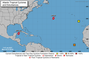
I'm prepared even though I'm on the east coast because you truly just don't know. Besides, they all playing out there and we don't want none of them to come up behind micheal and messing us up.
1082018two_atl_0d0.png
 

Arcadian

Ideal_Rock
Premium
Joined
Sep 17, 2008
Messages
9,089
When I went out in the car briefly I heard that Michael had become a hurricane. I thought of whitewave. Are you going to be affected now? Arcadian?

https://www.cbsnews.com/news/hurricane-michael-latest-track-path-weather-forecast-today-2018-10-08/


Deb, it depends on how big it gets. For instance, if its a cat 2 and 400 miles wide, yeah it will pretty much suck for anybody in Florida at that point! If you recall, Irma was a very big storm and the penensula is really not that wide (less than 170miles!!) so the entire state was under it. I'd like to avoid anything that big.

But its mostly about the position of the eye. If the eye jogs east, that means the whole darn thing jogs east and we'll see deterioration of our forecast here and they will have to activate evacuation zones (likely A and B).

If it jogs west, then it will be more panhandle/Alabama. Georgia is getting hit no matter what.

As it stands on the east side we'll get TS force winds, high surf, and the rain for several days as it passes. I stay prepared because you just never know with the darn things.
 

Arcadian

Ideal_Rock
Premium
Joined
Sep 17, 2008
Messages
9,089
The latest forecast:
000
WTNT34 KNHC 081438
TCPAT4

BULLETIN
Hurricane Michael Advisory Number 8
NWS National Hurricane Center Miami FL AL142018
1100 AM EDT Mon Oct 08 2018

...MICHAEL BECOMES A HURRICANE AND CONTINUED STRENGTHENING
EXPECTED...
...HEAVY RAINFALL AND STRONG WINDS SPREADING ACROSS WESTERN CUBA...
...RISK OF LIFE-THREATENING STORM SURGE...HEAVY RAINFALL...AND
DANGEROUS WINDS INCREASING FOR THE NORTHEASTERN GULF COAST...


SUMMARY OF 1100 AM EDT...1500 UTC...INFORMATION
-----------------------------------------------
LOCATION...21.2N 84.9W
ABOUT 50 MI...80 KM S OF THE WESTERN TIP OF CUBA
ABOUT 140 MI...220 KM ENE OF COZUMEL MEXICO
MAXIMUM SUSTAINED WINDS...75 MPH...120 KM/H
PRESENT MOVEMENT...N OR 10 DEGREES AT 7 MPH...11 KM/H
MINIMUM CENTRAL PRESSURE...982 MB...29.00 INCHES


WATCHES AND WARNINGS
--------------------
CHANGES WITH THIS ADVISORY:

None

SUMMARY OF WATCHES AND WARNINGS IN EFFECT:

A Hurricane Warning is in effect for...
* The Cuban province of Pinar del Rio

A Tropical Storm Warning is in effect for...
* The Cuban province of the Isle of Youth
* The coast of Mexico from Tulum to Cabo Catoche, including Cozumel

A Storm Surge Watch is in effect for...
* Navarre Florida to Anna Maria Island Florida, including Tampa Bay

A Hurricane Watch is in effect for...
* Alabama-Florida border to Suwannee River Florida

A Tropical Storm Watch is in effect for...
* Suwannee River to Anna Maria Island Florida, including Tampa Bay
* Alabama-Florida border to the Mississippi-Alabama border

A Hurricane Warning means that hurricane conditions are expected
somewhere within the warning area.

A Tropical Storm Warning means that tropical storm conditions are
expected somewhere within the warning.

A Storm Surge Watch means there is a possibility of life-
threatening inundation, from rising water moving inland from the
coastline, in the indicated locations during the next 48 hours.
For a depiction of areas at risk, please see the National Weather
Service Storm Surge Watch/Warning Graphic, available at
hurricanes.gov.

A Hurricane Watch means that hurricane conditions are possible
within the watch area. A watch is typically issued 48 hours
before the anticipated first occurrence of tropical-storm-force
winds, conditions that make outside preparations difficult or
dangerous.

A Tropical Storm Watch means that tropical storm conditions are
possible within the watch area, generally within 48 hours.

Interests elsewhere across the southeastern United States should
monitor the progress of Michael.

For storm information specific to your area in the United
States, including possible inland watches and warnings, please
monitor products issued by your local National Weather Service
forecast office. For storm information specific to your area outside
the United States, please monitor products issued by your national
meteorological service.


DISCUSSION AND OUTLOOK
----------------------
At 1100 AM EDT (1500 UTC), the center of Hurricane Michael was
located near latitude 21.2 North, longitude 84.9 West. Michael is
moving toward the north near 7 mph (11 km/h). A northward motion at
a slightly faster forward speed is expected through Tuesday night,
followed by a northeastward motion on Wednesday and Thursday. On the
forecast track, the center of Michael will move northward near the
western tip of Cuba this afternoon and into the southeastern Gulf of
Mexico by tonight. Michael will move across the eastern Gulf of
Mexico Tuesday and Tuesday night, and is expected to move inland
over the Florida Panhandle or Florida Big Bend area on Wednesday,
and then move northeastward across the southeastern United States
Wednesday night and Thursday.

Data from an Air Force Reserve Hurricane Hunter aircraft indicate
that maximum sustained winds have increased to near 75 mph (120
km/h) with higher gusts. Steady to rapid strengthening is forecast
during the next day or so, and Michael is forecast to become a major
hurricane by Tuesday or Tuesday night.

Hurricane-force winds extend outward up to 30 miles (45 km) from the
center and tropical-storm-force winds extend outward up to 175 miles
(280 km).

The estimated minimum central pressure based on Air Force Reserve
reconnaissance data is 982 mb (29.00 inches).


HAZARDS AFFECTING LAND
----------------------
STORM SURGE: The combination of a dangerous storm surge and the
tide will cause normally dry areas near the coast to be flooded by
rising waters moving inland from the shoreline. The water has the
potential to reach the following heights above ground if peak surge
occurs at the time of high tide...

Indian Pass to Crystal River...8-12 ft
Okaloosa/Walton County Line to Indian Pass...5-8 ft
Crystal River to Anclote River...4-6 ft
Anclote River to Anna Maria Island including Tampa Bay...2-4 ft
Navarre to Okaloosa/Walton County Line...2-4 ft

WIND: Hurricane conditions will spread across the far western part
of the Cuban province of Pinar del Rio this afternoon and evening.
Tropical storm conditions are expected across the remainder of the
warning areas in Cuba and the Yucatan Peninsula later today.

Hurricane conditions are possible within the hurricane watch area
along the U.S. Gulf Coast by Wednesday, with tropical storm
conditions possible by Tuesday night or early Wednesday. Tropical
storm conditions are possible within the tropical storm watch area
by Tuesday night or early Wednesday.

RAINFALL: Michael is expected to produce the following rainfall
amounts through the weekend...

Western Cuba...4 to 8 inches, with isolated maximum amounts of 12
inches. This rainfall could lead to life-threatening flash floods
and mudslides.

Florida Panhandle and Big Bend into the Carolinas...4 to 8
inches, with isolated maximum amounts of 12 inches. This rainfall
could lead to life threatening flash floods.

Florida Peninsula, Florida Keys, portions of the Mid-Atlantic
States, and the southern New England coast...2 to 4 inches with
local amounts of 6 inches. This rainfall could lead to life-
threatening flash floods.

Yucatan Peninsula...1 to 2 inches.

SURF: Swells generated by Michael are affecting the south coast of
Cuba and the east coast of the Yucatan Peninsula. Swells are
expected to begin affecting the coast of the eastern and northern
Gulf of Mexico during the next day or so. These swells are likely
to cause life-threatening surf and rip current conditions. Please
consult products from your local weather office.


NEXT ADVISORY
-------------
Next intermediate advisory at 200 PM EDT.
Next complete advisory at 500 PM EDT.

$$
Forecaster Brown
 

whitewave

Super_Ideal_Rock
Premium
Joined
Feb 29, 2012
Messages
12,331
We should be fine as long as it goes east. Central or west would put me in it...
 

Arcadian

Ideal_Rock
Premium
Joined
Sep 17, 2008
Messages
9,089
So at least here we'll see some flooding along the coast (figures) LIkely not mandatory for zone A&B but might be highly advised. Ignore the thing about rip currents, we always get those.

Coastal Flood Statement for Coastal Palm Beach County, Florida
Until 8:00pm EDT, Tue Oct 9

Action Recommended: Attend to information sources as described in the instructions
Issued by: Miami - FL, US, National Weather Service,

...MINOR TIDAL FLOODING POSSIBLE AROUND HIGH TIDES THROUGH AT LEAST TUESDAY... ...HIGH RIP CURRENT RISK REMAINS IN EFFECT THROUGH TUESDAY EVENING... * COASTAL FLOODING...Sensitive and low-lying locations along the Atlantic coast may experience minor flooding near times of high tide. * TIMING...Through at least Tuesday evening. The next high tides are around 8 AM this morning and 8 PM this evening. * RIP CURRENTS...Strong rip currents will be hazardous to those in the surf zone along the Atlantic beaches. PRECAUTIONARY/PREPAREDNESS ACTIONS... There is a high risk of rip currents. Rip currents are powerful channels of water flowing quickly away from shore, which occur most often at low spots or breaks in the sandbar and in the vicinity of structures such as groins, jetties and piers. Heed the advice of lifeguards, beach patrol flags and signs. Swim near a lifeguard. If caught in a rip current, relax and float. Don't swim against the current. If able, swim in a direction following the shoreline. If unable to escape, face the shore and call or wave for help. &&
 

Arcadian

Ideal_Rock
Premium
Joined
Sep 17, 2008
Messages
9,089
We should be fine as long as it goes east. Central or west would put me in it...

Have you heard anything n how side across this thing is? I'm looking but not finding it.
 

whitewave

Super_Ideal_Rock
Premium
Joined
Feb 29, 2012
Messages
12,331
Have you heard anything n how side across this thing is? I'm looking but not finding it.

Not yet. We are in the car headed to New Orleans for Monday night football
 

whitewave

Super_Ideal_Rock
Premium
Joined
Feb 29, 2012
Messages
12,331
But it looks like we are going to be wearing panchos to the tailgate.

I’ll check the local weather when we get there.
A0C24A62-10E1-44BE-B559-97C4B79BE0B4.jpeg

The lake is a bit choppy.
 
Be a part of the community Get 3 HCA Results
Top