shape
carat
color
clarity

We have more storms hitting the gulf

Arcadian

Ideal_Rock
Premium
Joined
Sep 17, 2008
Messages
9,086
OK kids we got something brewing! That spot from my post on October 12 moved and its fixin to do something, but we don't know what.....
10-23-2020two_atl_2d0.png

if you recall I was worried...and well...yeah.
 

Arcadian

Ideal_Rock
Premium
Joined
Sep 17, 2008
Messages
9,086
10-24-2020two_atl_2d0.png

So how to say it? could be nothing but rain, could be a real storm, tomorrow and its position is supposed to tell the tale, but its sitting there right how and models are all over the place.
 

Arcadian

Ideal_Rock
Premium
Joined
Sep 17, 2008
Messages
9,086
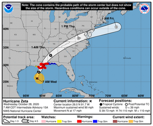
Sorry gulf friends but yeah its ugly out there. I believe we're looking at a landfall of Wednesday?
The good is that its a fast moving storm. the bad is that it's strengthened.

There's an expectation of shear happening, pushing activity to the east.

Hurricane fatigue is real!! I can barely remember some of the earlier storms of the season!

zeta091827_5day_cone_no_line_and_wind.png

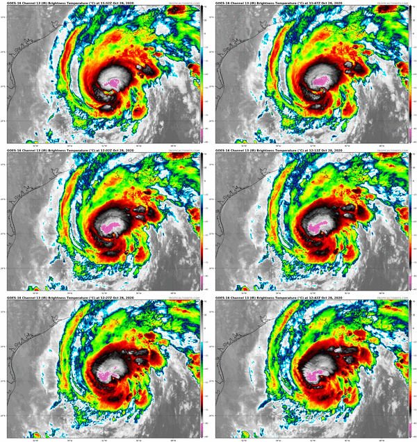
goes16_ir_28L_202010281132.gif


Panhandle is not in the cone but they'll feel it for sure! hopefully they got those damn barges secured.

@whitewave hang in there!
 

missy

Super_Ideal_Rock
Premium
Joined
Jun 8, 2008
Messages
53,980
Ugh. Hang in there everyone. 2020 is the year that keeps on giving and giving and giving cr**. But we’ll get through it. Hugs to all affected. @Arcadian @whitewave and everyone else.

5A391F78-F333-4B35-B4CF-6007C6B207EE.jpeg
 

tyty333

Super_Ideal_Rock
Premium
Joined
Dec 17, 2008
Messages
27,198
Poor New Orleans/Louisiana ...they just cant catch a break!
 

Arcadian

Ideal_Rock
Premium
Joined
Sep 17, 2008
Messages
9,086
Zeta barely finished and there's another spot that popped up on NHC's website. UGH!!!! :shock:

And also TWC apparently got caught doing a fako wind brace during Zeta :roll2: this is why I can't with them....
 

Arcadian

Ideal_Rock
Premium
Joined
Sep 17, 2008
Messages
9,086
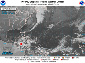
I've given y'all a break with hurricanes but we do have another brewing
etatwo_atl_2d0.png

The talk is what it will do after it hits Central America. GFS and Euro has been exceptionally bad at predicting the locations this year, however, GFS does have a possible US land threat, and we should see more by possibly November 6. There's more than a single storm in that area so we have to see what materializes.

This years hurricane season currently ties with 2005 but I got a feeling it will surpass. Might see a few more storms this year unfortunately.

Also I tracked that unfortunate storm in the Philippines which was really really bad. basically it was a super cyclone and another storm is following very close behind. :cry2:
 

Arcadian

Ideal_Rock
Premium
Joined
Sep 17, 2008
Messages
9,086
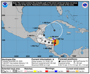
ETA is now a major hurricane and there will be lots of rain associated for Nicuagua and Honduras (lots of Central America actually!)

This is pretty awful. NHC did not upgrade to a cat 5 though they could have. Winds currently are 145MPH This storm is very slow moving and will be catastrophic.

ETA115722_5day_cone_no_line_and_wind.png

It WILL make its way back over hot water and this is where we'll know what it does. Some models are suggesting a possible Gulf hit. Other models are suggesting a possible Florida hit. One last night showed a straight up TX hit (its an outlier probably will not happen) No matter what it does, that Sunday position is going to be playing a huge part. @whitewave you guys have had enough but here's another one to watch.
 

PreRaphaelite

Ideal_Rock
Joined
Feb 2, 2015
Messages
3,564
Guess I better get the Jeep ready. If we have to bug out, it will be a mess. Fingers crossed for all the Floridians who can’t move quickly. I wish we could skip Winter entirely and fast forward into Spring. :(2
 

whitewave

Super_Ideal_Rock
Premium
Joined
Feb 29, 2012
Messages
12,331
ETA is now a major hurricane and there will be lots of rain associated for Nicuagua and Honduras (lots of Central America actually!)

This is pretty awful. NHC did not upgrade to a cat 5 though they could have. Winds currently are 145MPH This storm is very slow moving and will be catastrophic.

ETA115722_5day_cone_no_line_and_wind.png

It WILL make its way back over hot water and this is where we'll know what it does. Some models are suggesting a possible Gulf hit. Other models are suggesting a possible Florida hit. One last night showed a straight up TX hit (its an outlier probably will not happen) No matter what it does, that Sunday position is going to be playing a huge part. @whitewave you guys have had enough but here's another one to watch.

I know. I’m so exhausted. I have hurricane fatigue.
 

Arcadian

Ideal_Rock
Premium
Joined
Sep 17, 2008
Messages
9,086
Ok SoFL peeps listen up, its probably going to be us this time.
eta204709_5day_cone_no_line_and_wind.png

Intensity is going to be hard to measure, but that water is still bathtub warm. Models are showing cat 2-3 possible but IMO still too far out to tell what we're going to be stuck with. If this thing goes up the east coast, yikes...
 

Arcadian

Ideal_Rock
Premium
Joined
Sep 17, 2008
Messages
9,086
eta120119_5day_cone_no_line_and_wind.png

there will be an update at 10am. pure devastation in central america unfortunately.
 

Arcadian

Ideal_Rock
Premium
Joined
Sep 17, 2008
Messages
9,086
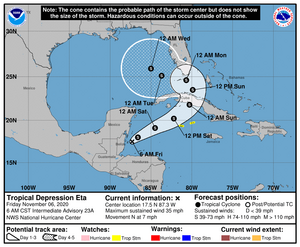
Oh gosh where to start with this one???

eta125801_5day_cone_no_line_and_wind.png

This storm was exceptionally bad in Central America. A friend down there saw lots of flooding in Panama, so was very far reaching.

So from what I know so far and what the models are saying, this has possibility of being a hurricane because waters are warm and, the possibility of no to low shear. Even at tropical storm strength, there will be a ton of water dropped out of this storm.

The storm is predicted to be wider than the entire peninsula which is only about 165 miles across) and have an "S" shaped path, so the entire peninsula will feel it no matter where you are as it travels north.


So technically a gulf storm but hitting Florida mostly. Other states might get some additional rain however.
 

Arcadian

Ideal_Rock
Premium
Joined
Sep 17, 2008
Messages
9,086
Extreme South FL and Keys are under tropical storm watch. The county blew up my phone with notices 20 minutes ago.
 

Arcadian

Ideal_Rock
Premium
Joined
Sep 17, 2008
Messages
9,086
We've been spending time packing things away so we don't have projectiles around the house. Otherwise we're pretty ready here. He has to go to his house to lock down things.

Today its been quite windy and rainy conditions, with expectation that it will deteriorate some today, and be pretty bad by Sunday.

Miami-Dade is under a Tropical storm warning. Counties to I believe to Port St Lucie are under Tropical Storm Watch. We've been having gale warnings since Thursday from Marathon to Jupiter for a while.

Projected wind if this thing stays a TS will be 30MPH with 55MPH gusts which is projected to start Sunday but will depend on the actual intensity which we don't know yet. That can still change.


Bridges in extreme south FL East coast will be locked down (basically from about Jupiter to Marathon) when winds reach 40MPH gusts. North of Jupiter should not have any issues unless the storm or track changes.
I'm trying to find out anything in the Naples area, but don't have anything yet. Anyone in Naples to Tampa should be watching as it makes its way across.

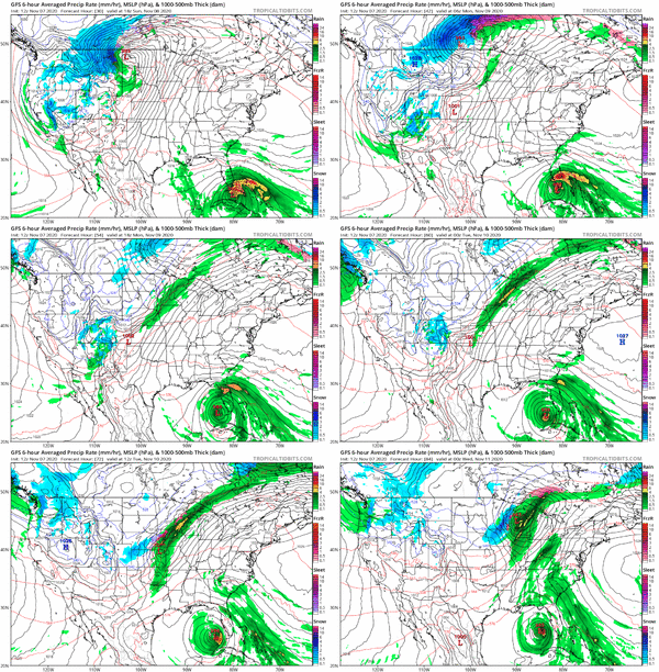
The hope is that it stays a TS and not reach Hurricane status. That can change the game significantly. Still, massive rains with flooding on both sides of the peninsula (and especially at the coast) is something to be watchful for. We will go through beach erosion because the surf is very high. My area is expecting 10+ inches of rain, yikes.

There's enough model agreement to actually post this one.

gfs_mslp_pcpn_frzn_us_fh30-84.gif
 

Arcadian

Ideal_Rock
Premium
Joined
Sep 17, 2008
Messages
9,086
There was an update (and you all will be getting more of them from me!)

"Reports from an Air Force Reserve Hurricane Hunter aircraft indicate
that the maximum sustained winds in Eta have increased to 50 mph.
The plane is still investigating Eta at this time. If it finds
stronger winds, a special advisory may be required during the next
hour or two. "

So will see what the update is going to be but looking at some rapid intensification.
Im pretty sure they'll be going in there a few times today possibly.
 

Arcadian

Ideal_Rock
Premium
Joined
Sep 17, 2008
Messages
9,086

Thankfully you'll be on the west side of this one, so, maybe rain for you ...lets hope its only a few sprinkles. Aside from the Panhandle, FL has been pretty lucky this year so now we're getting a double hit as long as the storm stays a TS and continues to move as fast as it is now, awesome. fine. There's going to be some spots still left to watch but don't think they'll go for land (at least we hope not!) This season has been extra, along with everything else 2020 :roll2:

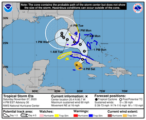
Tropical Storm Warnings/ Hurricane Watches are now up for South Fl and there's been a small easterly cone shift.
11-7-2020210059_5day_cone_no_line_and_wind.png
 

canuk-gal

Super_Ideal_Rock
Premium
Joined
Apr 19, 2004
Messages
25,649
HI:

Lordy. Stay safe!!!!!

cheers--Sharon
 

PreRaphaelite

Ideal_Rock
Joined
Feb 2, 2015
Messages
3,564
Given its projected track, I will be preparing on Monday to leave the area. If I waited until Wednesday, the path of egress will be clogged.
 

Arcadian

Ideal_Rock
Premium
Joined
Sep 17, 2008
Messages
9,086
@PreRaphaelite stay safe and let us know how you're doing. I should be OK as I'm not in a flood prone area.


Pressure is dropping and reported to be 991 currently which is never good. Storm might stick around and swirl in the gulf though, which is going to be so freaking odd... But, will dependend when the low out of the midwest comes through and sweeps it up. Georgia and the carolinas will get the leftovers.

New track at 10pm EST, trying to stay awake for it...lol
 

missy

Super_Ideal_Rock
Premium
Joined
Jun 8, 2008
Messages
53,980
Given its projected track, I will be preparing on Monday to leave the area. If I waited until Wednesday, the path of egress will be clogged.

Stay safe @PreRaphaelite I know too well the terrible feeling of having to evacuate and not knowing what you might find when you come back...sending many good vibes and well wishes you and your loved ones way.

And you too @Arcadian and @whitewave I hope you stay out of the storm's path.
C'mon already Mother Nature.
Please give everyone a respite.
So many storms this season.

Sending safety vibes everyone's way.
 

Arcadian

Ideal_Rock
Premium
Joined
Sep 17, 2008
Messages
9,086
Did not stay awake but thats ok, I was plenty tired and quite the cheap drunk...lol

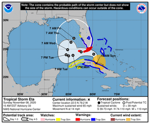
The readings are weird, nobody can figure this thing out. It looks like it might end up being a low cat-1 hurricane going over the keys but this one has everyone scratching their heads!

160819_5day_cone_no11-8-2020_line_and_wind.png

We have very windy conditions with rain where I am which I'm told will continue. I guess its going to be a wait and see for most of us but, Keys will get the eye.
 

Arcadian

Ideal_Rock
Premium
Joined
Sep 17, 2008
Messages
9,086
Eta has emerged from Cuba and is in the FL straights. My head feels like a bongo right now...lol I haven't heard of any strengthening but there's an ongoing recon that looks to be nearly finished and finding 993-994MB pressure.


and there's a little friend behind ETA...currently at 20% so I'm hoping it kinda just dies.
 

Arcadian

Ideal_Rock
Premium
Joined
Sep 17, 2008
Messages
9,086
Eye is rolling in and we're getting 54mph gusts here. Lights are flickering, and lot of rain
 

tyty333

Super_Ideal_Rock
Premium
Joined
Dec 17, 2008
Messages
27,198
How did you survive last night? It was crazy here. High winds and rain hitting the windows. It was very noisy with swirling winds. I didnt
get much sleep. I checked the yard this morning and surprisingly we've only lost large twigs and nothing bigger.

In-person school was canceled for today. My DD only goes in for orchestra though. The rest are on-line. Kind of nice I dont have to worry
about it today.

So, I have no idea if we're going to get more bad weather or what??? This thing doesnt look like its in a hurry to go anywhere. I guess we'll
wait and see.

Let us know how you did @Arcadian (and anyone else who is in the area)!
 

Arcadian

Ideal_Rock
Premium
Joined
Sep 17, 2008
Messages
9,086
Last night was Crazy. 1 water spout/ tornado. We still have electricity though. Some locations south took some serious hits. @tyty333 there's a huge cell coming onshore near you.

We have eta for the week they're saying.
 

tyty333

Super_Ideal_Rock
Premium
Joined
Dec 17, 2008
Messages
27,198
Last night was Crazy. 1 water spout/ tornado. We still have electricity though. Some locations south took some serious hits. @tyty333 there's a huge cell coming onshore near you.

We have eta for the week they're saying.

Well, thats not good news! Glad you're doing ok down there. I'm on the east coast. I thought it was more on the west coast but I can see that
its big enough to cover the state :shock:. I wish it would do its thing and move on through. I guess we'll just have to wait this one out!
 

Arcadian

Ideal_Rock
Premium
Joined
Sep 17, 2008
Messages
9,086
Well, thats not good news! Glad you're doing ok down there. I'm on the east coast. I thought it was more on the west coast but I can see that
its big enough to cover the state :shock:. I wish it would do its thing and move on through. I guess we'll just have to wait this one out!

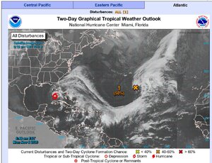
Yeah well...2020 :lol: We're still under watches here and probably will for the rest of the day. parts of the keys had a "a dry eye" with most of the convection was to the north and east. they're getting more rain now though! Homestead up got crapped on basically. The entire east coast is now getting those wrap around bands with more of it coming the rest of the day.

Several friends south of me took on a lot of water. One is currently camping out in my driveway (they have a very nice RV with a freaking bump-out!!) They lost power, their home is right on the ocean but its plenty bad where they are with lots of standing water. They've already had coronavirus and donating blood to help others so, I'm taking the chance because I'd rather them be where I am than be where there's no electric. Plus we love their doggos and they now have a yard to hang out in.

This is a great image to show exactly whats happening. And yeah, another spot at 50%. :roll2: There's another unshown spot that was 20% last night, it may reappear, its been a weird BOGO year.

eta11-9-2020Capture.JPG
 
Be a part of the community Get 3 HCA Results
Top