You are using an out of date browser. It may not display this or other websites correctly.
You should upgrade or use an alternative browser.
You should upgrade or use an alternative browser.
We have more storms hitting the gulf
- Thread starter Arcadian
- Start date


- Joined
- Apr 25, 2014
- Messages
- 8,228
Have a look at https://www.ventusky.com for modelled weather - it's amazingly useful for a free site!
- Joined
- Sep 17, 2008
- Messages
- 9,087
Have a look at https://www.ventusky.com for modelled weather - it's amazingly useful for a free site!
I use https://www.tropicaltidbits.com/ because of the hardcorde data modeling that they use. I don't talk about it much, it would be too confusing...lol most sites like windy or ventusky use blended models which can sometimes be more off than on.
Speaking of, recon data is starting to show up on TD25 https://www.tropicaltidbits.com/recon/
- Joined
- Sep 17, 2008
- Messages
- 9,087
So I woke up this morning and see TS Gamma, a yet unnamed orange spot, and 2 yellow ones.... goodness.....

@dk168 heard that you guys were getting inclimate weather there! the storms this year seem to be all about the flooding, stay safe!!
Where I am we're getting frontal rains. The storm for us to watch is the one closest to Gamma, there's some uncertainty where the high will be at that time and its looking like it could hit in the vicinity of where Michael did (which is bad, that place has not recovered!)
Also gamma is already getting some dry air into it. and has to survive that + trip across Yucitan peninsula. Will keep it small (we hope) but the storm is already stacked, which is bad and its gaining strength right now.
Going to be an interesting day.

- Joined
- Sep 17, 2008
- Messages
- 9,087
We now have Delta. Gamma is naked  basically upper level clouds has sheared off, we're getting some of it in FL today. Gamma could be another Marco situation which pretty much whimpered at landfall. Delta by the models is supposed to develop into a hurricane.
Louisiana/Alabama/FL should be watching this as NHC has forecast it to be 05MPH at landfall.

Louisiana/Alabama/FL should be watching this as NHC has forecast it to be 05MPH at landfall.
- Joined
- Sep 17, 2008
- Messages
- 9,087
Delta is now a hurricane. I zonked out about 9pm so I don't know what happened with Gamma. Probably with the fact it was a naked swirl, it really had no where else to go!
At any rate Delta will be a hurricane at landfall in the gulf. the usual places, just have yourselves ready, its your year.
Pensacola Police Department put out a very timely message for those with heavy equipment...
Hopefully they heed it this time and not let it take out another part of the bridge.
Attachments
- Joined
- Jul 24, 2003
- Messages
- 2,601
Great, it will circle around and we will get more rain. 
- Joined
- Sep 17, 2008
- Messages
- 9,087
Great, it will circle around and we will get more rain.
Its been said that so far this year Louisiana has been in the cone 6 times. that is crazy (has to be a record!)
- Joined
- Sep 17, 2008
- Messages
- 9,087
Hurricane hunters are out right now
Basically cozumel and cancun, MX will get crapped on. by the 11am forecast, Delta is now a Cat4 and will make landfall there later tonight.
Also, timeframe for a US hit is Friday/Saturday. Its at night, which automaically means it will suck. US landfall is predicted to be as a Major Hurricane at 110MPH, and lets hope thats not coming true.
Last edited:
- Joined
- Sep 17, 2008
- Messages
- 9,087
Delta is now a cat4 @ 145MPH and looks to be on tap to get stronger. a few models has it at a cat5 by landfall. Officially NHC is saying it will hit as a major.
Also fyi, it keeps moving west. Texas, take note on this.
The good is that it will be a pretty fast moving storm..

Also fyi, it keeps moving west. Texas, take note on this.
The good is that it will be a pretty fast moving storm..
Daisys and Diamonds
Super_Ideal_Rock
- Joined
- Apr 30, 2019
- Messages
- 22,776
Hunker down and do what ever you have to do to stay safe
- Joined
- Sep 17, 2008
- Messages
- 9,087
Delta is currently visiting Mexico I don't know what damage was done there but I recall one hurricane ripped through Cozumel and Cancun and left it ruined for a long time. This one has 105mph winds currently, so Cat2
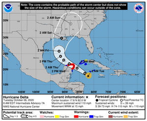
The cone has moved a tick east at the 8am advisory There's expectations that it could move west but no one really knows. Looking at the live they said that the TS winds are 135miles and HF winds are only 25 miles. very intersting facts actually.
While the air might be cool, the water is not. Hurricanes live and die by water temps. Land interaction and dry air can diminish storms however, its going to swing over some warmer waters in a little while.
- Joined
- Jun 8, 2008
- Messages
- 54,101
HI:
I think you guys have had enough!!!!!!!!!!!!!
cheers--Sharon
Agreed!
I think we all have had enough everywhere in the world!
Stay safe please everyone!!!
- Joined
- Sep 17, 2008
- Messages
- 9,087
Dont hunker down...pack up and leave if you are in the path of a Cat 4 or 5.
I know its a pain but better safe than sorry at this point. You guys have been pounded lately...
True on the Cat4-5 Thats not worth losing life over. There's high confidence on a 3 though@ 105mph which is still a strong storm! if this storm sucks in enough dry air it will keep it from getting that strong ( Currently its 75MPH ) I'm praying for some dry air to enter this thing, that area these storms keep hitting has had enough...
There does appear to be something week of Oct 20 but the models are all over the place. too far out but conditions are very favorable where it could form.
SallyBrown
Shiny_Rock
- Joined
- Oct 2, 2020
- Messages
- 386
Sending prayers!
- Joined
- Sep 17, 2008
- Messages
- 9,087
I won't bore you guys with anything at the moment because, Its being a hurricane. That swing is widening out though which is worrisome (should not go deep into TX because of the high however) I think they said Beaumont, TX will have something to worry about, they could get a decent part of it. Anything on the east side of course is what will get the worst because hurricanes rotate counter clockwise and east side gets the onshore flow.
If there's a major cchange between now and friday will post it. otherwise I think its just planning to intensify so there is that. Current sustained winds are 100MPH.
If there's a major cchange between now and friday will post it. otherwise I think its just planning to intensify so there is that. Current sustained winds are 100MPH.
- Joined
- Sep 17, 2008
- Messages
- 9,087

Leaving today is going to be out of the question. They're saying current speed is 120MPH possibly sustaining this until landfall. The eye is a bit smaller which is great, it was a much bigger eye, the dry air helped it shrink some.
The unfortunate part of all this is how much damage is already on the ground where its coming ashore and, that stuff will be blown about. They're still saying it will come ashore during the evening hours.
Biggest worries are the amount of surge and additional water thats going to be going over some already saturated ground.


- Joined
- Sep 17, 2008
- Messages
- 9,087
From what I can figure its a few hours until the eye comes on shore. Storm has started to pick up some speed which is good. Its gotten a bit bigger but wind speed is about 105? thats better than it was!
00
WTNT61 KNHC 092157
TCUAT1
Hurricane Delta Tropical Cyclone Update
NWS National Hurricane Center Miami FL AL262020
500 PM CDT Fri Oct 09 2020
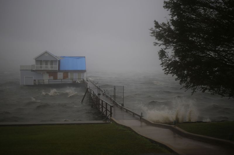
...5 PM CDT POSITION UPDATE...
...EYEWALL OF DELTA MOVING ONSHORE OF THE SOUTHWESTERN COAST OF
LOUISIANA...
A NOAA National Ocean Service water level gauge at Freshwater Canal
Locks, Louisiana, recently reported storm surge inundation of over
7 feet above ground level.
A WeatherFlow observing site near Cameron, Louisiana, recently
reported a sustained wind of 58 mph (93 km/h) and a wind gust to
78 mph (125 km/h)
The Texas Coastal Ocean Observation Network station at Texas Point
recently reported sustained winds of 65 mph (105 km/h) and a wind
gust of 74 mph (119 km/h).
A wind gust to 71 mph (114 km/h) has been reported at the Jack
Brooks Regional Airport near Port Arthur, Texas, within the past
couple of hours.
SUMMARY OF 500 PM CDT...2200 UTC...INFORMATION
----------------------------------------------
LOCATION...29.5N 93.1W
ABOUT 25 MI...40 KM SSE OF CAMERON LOUISIANA
MAXIMUM SUSTAINED WINDS...100 MPH...155 KM/H
PRESENT MOVEMENT...NNE OR 15 DEGREES AT 14 MPH...22 KM/H
MINIMUM CENTRAL PRESSURE...968 MB...28.58 INCHES
$$
Forecaster Brown
- Joined
- Jun 8, 2008
- Messages
- 54,101
Weakened Delta brings heavy rain and threat of flooding and tornadoes to Southeast | CNN
About 3 million people were under flood and flash flood watches on Saturday across parts of the Mississippi and Tennessee river valleys as the remnants of Hurricane Delta continued to drench the Southeast.
Continued good wishes being sent to everyone who is affected and keeping you in my thoughts.
@Arcadian I hope the storm has left your area and you are safe and sound.
I had an alligator in my yard last night.
So over 2020
Oy. And same. 2020 is the year that keeps on giving and giving and giving...none of it good.
- Joined
- Sep 17, 2008
- Messages
- 9,087
I had an alligator in my yard last night.
So over 2020
oh wow..... thats crazy!
The only good about the storm is that it wasn't a slow mover, but I did see the power outtage maps and its pretty bad.
- Joined
- Feb 29, 2012
- Messages
- 12,331
oh wow..... thats crazy!
The only good about the storm is that it wasn't a slow mover, but I did see the power outtage maps and its pretty bad.
The alligator is gone, but we still don’t have power. MIL and my kids all have power. Our one way in and out bridge is submerged by the bayou, so....

- Joined
- Sep 17, 2008
- Messages
- 9,087
@whitewave I'm hoping you guys have electric!! (if not then soon!)
There's another little spot that could be hitting SoFL I'm really watching this one as it could go right up the peninsula! Where the high will be is going to tell the story but should not hit The Gulf as there is supposed to be a blocking high there.
Matthew hit right before Halloween and the season is not done yet!!

Gonna show you why I'm worried about that little x

There's another little spot that could be hitting SoFL I'm really watching this one as it could go right up the peninsula! Where the high will be is going to tell the story but should not hit The Gulf as there is supposed to be a blocking high there.
Matthew hit right before Halloween and the season is not done yet!!
Gonna show you why I'm worried about that little x
Last edited:

Did You Miss the March 2024 Jewels of the Weeks?
Did You Miss the March 2024 Jewels of the Weeks? - 03/30

300x240.png)