shape
carat
color
clarity

We have more storms hitting the gulf

Arcadian

Ideal_Rock
Premium
Joined
Sep 17, 2008
Messages
9,086
we're currently getting soaked, not that we need it Eta is still affecting SoFL!
  • Eta is now close to Cuba and will be sitting there at least through today I believe
  • Theta formed last night. could be a possible Tropical storm to Portugal
  • An unnamed spot that might be a Thanksgiving storm if you go by the models
Eta is supposed to (if the tracks are to be believed) get closer to FL again and then be swept up into another low. However, I've seen some tracks where it goes right into Louisiana (that place have a hurricane magnet on it this year?) And I've seen a tack where it crashes into Yucatan.

Time will tell but its gonna be with us the rest of the weak
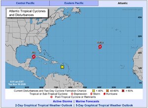
11-10-2020 eta.JPG

So FL on the east side, Broward County and below, was hit pretty hard. We've had tons of water prior to this storm and it dropped lots more. Miami floods if you think too hard as it is, and this time it was knee deep in many places downtown.

The beaches are pretty decimated. Lot of serious beach erosion even in Jupiter.

I have not heard reports from the west coast as Naples also floods easy, so hopefully they escaped most of it.

Will see what the day brings....manoman...
 

Arcadian

Ideal_Rock
Premium
Joined
Sep 17, 2008
Messages
9,086
Well, we may have something crazy to deal with the next couple of days. 10pm track will tell if there's a massive change and we're back under watches.
 

Arcadian

Ideal_Rock
Premium
Joined
Sep 17, 2008
Messages
9,086
Eta is now a hurricane. Those on the West Coast of FL you have today to decide what to do.
From what some have said this is another Wilma.

194
WTNT64 KNHC 111239
TCUAT4

Hurricane Eta Tropical Cyclone Update
NWS National Hurricane Center Miami FL AL292020
735 AM EST Wed Nov 11 2020

...ETA BECOMES A HURRICANE AGAIN OFFSHORE OF SOUTHWESTERN FLORIDA...

Reports from a NOAA Hurricane Hunter aircraft and Doppler radar data
indicate that Eta has re-strengthened into a hurricane offshore the
southwestern coast of Florida, with maximum sustained winds of 75
mph (120 km/h), with higher gusts.


SUMMARY OF 735 AM EST...1235 UTC...INFORMATION
----------------------------------------------
LOCATION...25.8N 83.8W
ABOUT 130 MI...210 KM WSW OF FT. MYERS FLORIDA
ABOUT 170 MI...270 KM SSW OF TAMPA FLORIDA
MAXIMUM SUSTAINED WINDS...75 MPH...120 KM/H
PRESENT MOVEMENT...NNE OR 15 DEGREES AT 15 MPH...24 KM/H
MINIMUM CENTRAL PRESSURE...983 MB...29.03 INCHES

$$
Forecaster Stewart
all of the peninsula will feel it as it comes closer (its a big storm, you know what that means....)

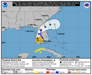
This is the projected track but it could also be wrong, its certainly a weird one
Eta114331_5day_cone_no_line_and_wind.png
 

PreRaphaelite

Ideal_Rock
Joined
Feb 2, 2015
Messages
3,564
It will hit me tonight, but meanwhile it’s rainy and very very still. I have brought in the plants, and made sure the pets had some outside time, but I’ll be staying put through the storm. If we lose power I will be grumpy, but we have a generator and that’s the best I can do. Hoping everyone else is safe and comfortable today!
 

Arcadian

Ideal_Rock
Premium
Joined
Sep 17, 2008
Messages
9,086
@PreRaphaelite Stay safe! do check in when you can! I'm southeast of you and we have super gusty conditions right now from the wrap around bands with showers.

Its been so rainy here I have huge mold spores growing on the outside of my clay pots :shock:
 

Arcadian

Ideal_Rock
Premium
Joined
Sep 17, 2008
Messages
9,086
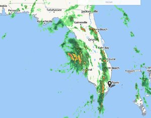
We're getting ready to get crapped on in about an hour. West Florida even more so than east (we're soggy, going to be even more soggy) We will have coastal flooding for a good deal of SoFL sadly! As my house is due east/west, I look out my in the back of my house and I can see the line of storms coming. its freaky.

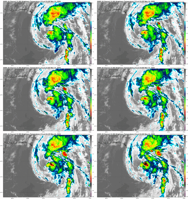
So as you can see, the eye is pretty naked and most of the convection is to the east of the storm.

At this late stage only radar is going to be reliable enough to show this.


storms11-11-2020Capture.JPG

The IR Loop
goes16_ir_29L_202011112122.gif
 

Arcadian

Ideal_Rock
Premium
Joined
Sep 17, 2008
Messages
9,086
This season sucked. I just needed to say that. There's a potential named storm that might show itself tomorrow. Model guidance currently shows it not making it to the gulf. Lets hope that holds out.
 
Be a part of the community Get 3 HCA Results
Top