shape
carat
color
clarity

East Coast Systems Forming

Arcadian

Ideal_Rock
Premium
Joined
Sep 17, 2008
Messages
9,086
Can tell you that the last couple of days we've had super gusty winds and lots of high clouds coming from the east from this thing.

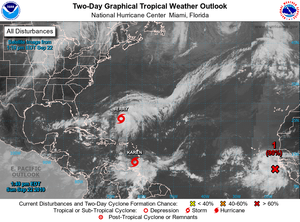
https://www.nhc.noaa.gov/gtwo.php?basin=atlc&fdays=5

9-12-2019two_atl_5d0.png
So there's a couple of systems that are forming off the coast, one is 80% currently. Could be nothing, could be everything. But expect they'll turn one of these into a hurricane.

We shall see what 11AM brings. Here we go again! Keep watch coastal folks!
 
  • Like
Reactions: AV_

AGBF

Super_Ideal_Rock
Premium
Joined
Jan 26, 2003
Messages
22,143
Stay safe! :wavey:
 

Arcadian

Ideal_Rock
Premium
Joined
Sep 17, 2008
Messages
9,086
Stay safe! :wavey:

Well you have to also be careful because could be you too. Some of the models are saying it could go up the east coast (hitting the Outter Banks yet again) and going close to NY.
 
  • Like
Reactions: AV_

AGBF

Super_Ideal_Rock
Premium
Joined
Jan 26, 2003
Messages
22,143
Well you have to also be careful because could be you too. Some of the models are saying it could go up the east coast (hitting the Outter Banks yet again) and going close to NY.

Indeed. Hurricane Sandy came close to us, and we do get hit by hurricanes in Connecticut. With the weather weirding who knows what will happen next! Of course, the nor' easters here are also fun. They should be coming soon. :))
 

Mayk

Ideal_Rock
Premium
Joined
Feb 12, 2011
Messages
4,772
In denial!
 

whitewave

Super_Ideal_Rock
Premium
Joined
Feb 29, 2012
Messages
12,331
I’m leaving on a cruise on Saturday, so if you hear of a cruise ship circling because we can’t get back to port, I am happy as a clam and having a drink of the day lol.

Good luck to everyone.
 

Tekate

Ideal_Rock
Premium
Joined
May 11, 2013
Messages
7,570
@Arcadian been keeping an eye out myself Arcadian as I have said, we have close friends in the Keys on Big Pine Key and man a few years ago they were decimated.. Thanks for the info and here's to hoping it all amounts to some rain.
 

Tekate

Ideal_Rock
Premium
Joined
May 11, 2013
Messages
7,570
Nosey old gal I am, are you doing the Caribbean? be safe.. I was on a Spain to FL crossing of the Atlantic in 2013 in September and we hit a named storm and had to go way south then back up and missed most of Bermuda, we had 3 hours ha! anyway, the pool was amazing the water was like a centrifuge, bizarre (couldn't go in of course) and man oh man seasickness abounded, so far knock on wood we don't get it, our last cruise was the Danube last Christmas, be safe and HAVE FUN!


I’m leaving on a cruise on Saturday, so if you hear of a cruise ship circling because we can’t get back to port, I am happy as a clam and having a drink of the day lol.

Good luck to everyone.
 

whitewave

Super_Ideal_Rock
Premium
Joined
Feb 29, 2012
Messages
12,331
Nosey old gal I am, are you doing the Caribbean? be safe.. I was on a Spain to FL crossing of the Atlantic in 2013 in September and we hit a named storm and had to go way south then back up and missed most of Bermuda, we had 3 hours ha! anyway, the pool was amazing the water was like a centrifuge, bizarre (couldn't go in of course) and man oh man seasickness abounded, so far knock on wood we don't get it, our last cruise was the Danube last Christmas, be safe and HAVE FUN!


Yes, it’s a quick 5 day to progreso Mexico and Cozumel. With 6 other friends.
 

Arcadian

Ideal_Rock
Premium
Joined
Sep 17, 2008
Messages
9,086
Well whitewave, its shaping up to be a wind/rain event. You're going to be perfectly fine to enjoy your cruise without any extra days...lol
9-13-2019storm174400_5day_cone_no_line_and_wind.png

VERY Breezy rainy for the last day. One of the neighbors car alarms keeps going off every time the wind gusts...(annoying!!!! :angryfire:)

Because of the recovery efforts going on in the Bahamas, this is really one of the last things they need.

The hope is that of course if it turns into a hurricane it does it far enough off shore. Some of the models I've seen had it going into New York/New Jersey, so stay watchful folks.
 

whitewave

Super_Ideal_Rock
Premium
Joined
Feb 29, 2012
Messages
12,331
Thanks!!
 

Arcadian

Ideal_Rock
Premium
Joined
Sep 17, 2008
Messages
9,086
Nine is officially a depression. most models have it moving further out to sea so lets hope that holds. Apparently it will encounter a strong high which keeps it off shore (yay!) and that also means that it may also not be anywhere near the US for its duration as a hurricane (if it reaches that level) Lets hope it doesn't.
9officialdepression204921_5day_cone_no_line_and_wind.png

What it does on the weekend will be pretty telling. We continue to get blustery winds in SoFlo but not surprising.
 

Daisys and Diamonds

Super_Ideal_Rock
Joined
Apr 30, 2019
Messages
22,510
i hope this thing blows itself out and dissapairs asap
no more hurricans please
 

AGBF

Super_Ideal_Rock
Premium
Joined
Jan 26, 2003
Messages
22,143
@Arcadian been keeping an eye out myself Arcadian as I have said, we have close friends in the Keys on Big Pine Key and man a few years ago they were decimated.. Thanks for the info and here's to hoping it all amounts to some rain.

I had a friend on Big Pine Key, but she passed away a few years ago. I never went there. I do not believe I have ever heard anyone refer to it before. I didn't think it was very big.
 

Arcadian

Ideal_Rock
Premium
Joined
Sep 17, 2008
Messages
9,086
Still pretty gusty /semi stormy where I am. So looks like this storm could sideswipe Bermuda. It always amazed me how Bermuda escaped lots of storms.

Anyway this one isn't predicted to be that strong, but you never know, could have another Dorian on our hands that went from a clump of clouds to a cat 5 in nothing flat.

humberto173526_5day_cone_no_line_and_wind.png

There's a small system in the gulf, so keep an eye out. They're saying wind/rain event but never know. moving west to go into Mexico/Texas areas.
9-14-2019two_atl_2d0.png
 

Mayk

Ideal_Rock
Premium
Joined
Feb 12, 2011
Messages
4,772
New runs on some models are concerning for the states! Praying this thing skips past Bermuda on its way Northeast. 1896BB73-F44E-48E0-9C84-7AD148FA84EF.jpeg
 

Arcadian

Ideal_Rock
Premium
Joined
Sep 17, 2008
Messages
9,086
Here we go folks!
Tropical Depression 10
depression10144756_5day_cone_no_line_and_wind.png

This is the 5 day but the reality is, look at the first three days as this gives a better story as to what they're thinking will happen.

two_atl_2d0.png

And the entire Atlantic.....*sigh*
Texas, you're gonna get lotsa rain.

Its only Mid-September.... we need a break.
 

whitewave

Super_Ideal_Rock
Premium
Joined
Feb 29, 2012
Messages
12,331
So apparently TD 11 turned into a named storm and made landfall all in about 6 hours. The captain has already told us we will be bumpy tonight because we are headed into wind.
 

Arcadian

Ideal_Rock
Premium
Joined
Sep 17, 2008
Messages
9,086
So apparently TD 11 turned into a named storm and made landfall all in about 6 hours. The captain has already told us we will be bumpy tonight because we are headed into wind.

Yeah they named her late, which surprised me honestly!

9-18-2019two_atl_2d0.png

They're saying that Texas will be getting a lot of rain out of this...lots. Even some parts of Louisiana.

They named Jerry last night. Jerry by the models will follow after Humberto and could possibly skirt Bermuda.
 

Arcadian

Ideal_Rock
Premium
Joined
Sep 17, 2008
Messages
9,086
There are currently 6 named storms out there. My goodness. I'm only showing the Atlantic side of the house. Nothing on the Pacific side should run into anything as far as I could tell (maybe 1 in Mexico?)

9-18-2019-2two_atl_2d0.png

Jerry will indeed be a hurricane but there's some dissidence as to where he will be. And after Jerry is Karen. of course lots of Karen jokes going around...lol
 

Arcadian

Ideal_Rock
Premium
Joined
Sep 17, 2008
Messages
9,086
Bermuda is getting hit pretty hard from what I hear and will for the next few hours. The camera I was watching must have lost power. The island is very prepared thankfully.
 

Arcadian

Ideal_Rock
Premium
Joined
Sep 17, 2008
Messages
9,086
Karen has formed and looking for the manager:lol-2:

On a more serious note, there's a lot of uncertainty with that storm, not sure if its going north or, going west. models are not in total agreement at the moment but looks as if a high will cut Karen's trip north short... thats if she can survive the collision with the islands. I saw some models say that its possible to be in or near the gulf. Nothing is sure with Karen unfortunately.

karen174849_5day_cone_no_line_and_wind.png

The unnamed storm behind Karen is due to go go slightly west then north instead of due west so no threat to the islands or the US.

9-22-2019two_atl_5d0.png

Also, for the weather nerds in some of us, The Windy app is pretty cool.
https://www.windy.com
 

Attachments

  • 9-22-2019two_atl_2d0.png
    9-22-2019two_atl_2d0.png
    204.4 KB · Views: 60
  • Like
Reactions: AV_

Arcadian

Ideal_Rock
Premium
Joined
Sep 17, 2008
Messages
9,086
What in the world????

9-23-2019wtftwo_atl_2d0.png

OK so, Jerry is going off northeast.
Karen is gonna try to follow because she wants to speak to the damn manager about the mess, but looks to be getting stopped by high pressure.
However they could do the wild thing, more on that later
Lorenzo is coming on hot and heavy. :shock: with every minute he's getting bigger might be a hurricane either today sometime!
Jerry might be OK with that and seem to just wanna be with anybody , could merge with Lorenzo on the trip north.

These other little spots....not sure what they'll turn into (or not) for now they're bystanders...

But I guess this season ain't boring:lol-2::P2:lol-2:
 

YadaYadaYada

Super_Ideal_Rock
Premium
Joined
Feb 2, 2016
Messages
11,839
@Arcadian,

"The wild thing" :lol-2:

Your updates are a hoot!
 

Arcadian

Ideal_Rock
Premium
Joined
Sep 17, 2008
Messages
9,086
@Arcadian,

"The wild thing" :lol-2:

Your updates are a hoot!

Glad to entertain:wavey: Its because of hurricane fatigue that I'm just letting it all out there and having story time. Quite a few are in agreement that the forecasts called this year were just bad.

The silver lining in the current scenario is if Karen stays drunk and sloppy, she won't make it much past Puerto Rico. Can't count on it but can certainly hope for it. :pray: There's some models that show it could go into the gulf which is full of hurricane juice.
 

Arcadian

Ideal_Rock
Premium
Joined
Sep 17, 2008
Messages
9,086
Not sure if anyone heard about it, but there was an earthquake near Puerto Rico last night. Only a 6, but thats still quite a jolt for a place that isn't prepared for such a thing. AND they're preparing to be hit by newly non depressed Karen. I guess she listened to "I Will Survive" and did just that. Anyway Some models are showing that Karen might well merge with Jerry (good!) and move out to sea. A few models are showing looping and trying for another go. Could even merge with Lorenzo (and how freaky would that be?)

From Facebook (it was cute)
70599715_10219587015535588_1596122216422965248_n.jpg
 

Arcadian

Ideal_Rock
Premium
Joined
Sep 17, 2008
Messages
9,086
Models show Karen not surviving the next 48 hours. Good. Jerry barely made it to Bermuda. Lorenzo however is a monster.

We don't have to worry about him but UK folks might!
 

Arcadian

Ideal_Rock
Premium
Joined
Sep 17, 2008
Messages
9,086
Lorenzo is slated to hit Azores north most island though all the islands are under hurricane watch
Lorenzo115426_5day_cone_no_line_and_wind.png
 
  • Like
Reactions: AV_

Arcadian

Ideal_Rock
Premium
Joined
Sep 17, 2008
Messages
9,086
Hoping that everyone is the Azores is protected (beautiful islands I plan to go someday)
UK is going to get smacked with this. Not sure what its going to look like when it gets there but could be some serious rain.

lorenzo235157_5day_cone_no_line_and_wind.png
 

Arcadian

Ideal_Rock
Premium
Joined
Sep 17, 2008
Messages
9,086
Azores got hit on Flores. Some of the video I've seen had some extreme flooding. Not much else has come out so will see what else comes up.

The track continues to change (but of course) extratropical cyclone now. but still could hit with some very high winds for Ireland and the UK.

Lorenzo115942_5day_cone_no_line_and_wind.png
Last forecast from the US side

Post-Tropical Cyclone Lorenzo Discussion Number 41
NWS National Hurricane Center Miami FL AL132019
1100 AM AST Wed Oct 02 2019

Lorenzo has completed its transition into a powerful extratropical cyclone and this will be the last NHC advisory on this system. The center has become exposed on the southwestern edge of the cloud shield, and recent ASCAT data indicate that the system has acquired frontal features. The initial intensity is set at 70 kt, which is a little above the scatterometer data since there is typically a low bias in that instrument at these wind speeds. The global models suggest that the post-tropical cyclone will only gradually weaken during the next 24 to 36 hours as it approaches Ireland. A faster rate of weakening is expected Thursday night and Friday when the cyclone moves southeastward over Ireland and the United Kingdom. The low should dissipate over southeastern England by late Friday.

The cyclone continues to move rapidly northeastward or 040/37 kt, and this general motion should continue into Thursday. After that time, the cyclone is expected to turn eastward and then southeastward within an area of weaker westerly flow. The global model guidance is in good agreement, and the NHC track forecast is in closest to the ECMWF model.

Future hazard information on Lorenzo for Ireland and the United Kingdom can be found in products issued by Met Eireann and the United Kingdom Met Office.

Local forecasts and warnings for Ireland can be found on the website of Met Eireann, the Irish Meteorological Service, at
http://www.met.ie/.

Local forecasts and warnings for the United Kingdom can be found on the website of the UK Met Office at http://www.metoffice.gov.uk/.

Lorenzo's expansive circulation is producing very large seas over the north Atlantic. Full information can be found in High Seas Forecasts from the following agencies:

The NOAA Ocean Prediction Center under AWIPS header NFDHSFAT1, WMO header FZNT01 KWBC, and online at
ocean.weather.gov/shtml/NFDHSFAT1.php

The UK Met Office under WMO header FQNT21 EGRR and online at https://www.metoffice.gov.uk/weather/specialist-forecasts/coast-and-sea/high-seas-forecast

Meteo France under WMO header FQNT50 LFPW and online at http://www.meteofrance.com/previsions-meteo-marine/bulletin/grandlarge/metarea2

FORECAST POSITIONS AND MAX WINDS

INIT 02/1500Z 44.4N 25.8W 70 KT 80 MPH...POST-TROPICAL
12H 03/0000Z 48.6N 20.8W 70 KT 80 MPH...POST-TROP/EXTRATROP
24H 03/1200Z 52.8N 14.3W 65 KT 75 MPH...POST-TROP/EXTRATROP
36H 04/0000Z 54.0N 9.5W 60 KT 70 MPH...POST-TROP/EXTRATROP
48H 04/1200Z 52.5N 3.5W 40 KT 45 MPH...POST-TROP/EXTRATROP
72H 05/1200Z...DISSIPATED

$$
Forecaster Brown
 
  • Like
Reactions: AV_
Be a part of the community Get 3 HCA Results
Top