shape
carat
color
clarity

Dorian...Keeping an eye out

Arcadian

Ideal_Rock
Premium
Joined
Sep 17, 2008
Messages
9,091
For now its a storm. Lets hope it stays that way.

Creating this thread because I look at the models daily this time of year until the end of the season. (yes I'm that weird...lol) The islands and Southeast Florida needs to keep an eye on this one especially as it goes near some of the harder hit islands. Pressure is high at the moment in this one, which is hopeful that it stays that way (a lower pressure storm can be stronger/more destructive)

If any of you are going on vacation in the islands in the next few days, maybe you shouldn't. https://www.nhc.noaa.gov/text/refresh/MIATCPAT5+shtml/261446.shtml?
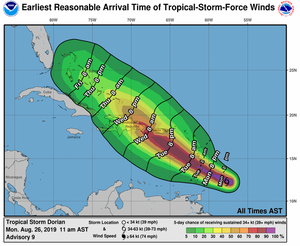
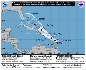
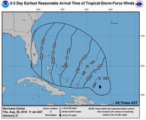
dorian150322_earliest_reasonable_toa_34.png
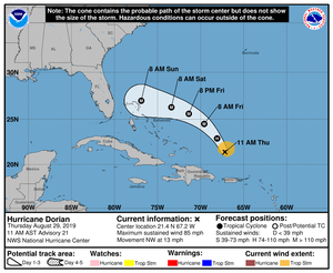
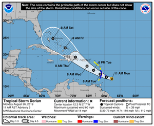
Dorian150322_5day_cone_no_line_and_wind.png
 

missy

Super_Ideal_Rock
Premium
Joined
Jun 8, 2008
Messages
54,136
I love the weather and am weird that way too. I am hoping for a quiet hurricane season for everyone please.:pray:
 

Tekate

Ideal_Rock
Premium
Joined
May 11, 2013
Messages
7,570
Taking a vacation to the Caribbean is iffy this time of year.. this looks it could be a whopper, I hope not! thank you for posting this.
 

Arcadian

Ideal_Rock
Premium
Joined
Sep 17, 2008
Messages
9,091
Taking a vacation to the Caribbean is iffy this time of year.. this looks it could be a whopper, I hope not! thank you for posting this.

its iffy anytime during hurricane season period...lol We took a cruise in 2007 in October and got caught up in a heck of a hurricane. I think thats the one that beat the crap out of Grand Cayman and made us miss our last stop (went to Key West instead)

An update to the probable path. They're saying a tropical storm by Saturday and by their images South Florida is gonna feel this one. Lets hope it stays this minor considering last major storm we had Miami stayed flooded for 10 days in some parts.

https://www.nhc.noaa.gov/text/refresh/MIATCPAT5+shtml/262040.shtml?

dorian204140_5day_cone_no_line_and_wind.png


Doubtful we lose electric where I am but you never know, its been constantly raining the last few weeks (which is ok I'm prepared!!) I was supposed to be in Miami over the weekend but I've cancelled those plans. If its going to suck I may as well be home for that...
 

Tekate

Ideal_Rock
Premium
Joined
May 11, 2013
Messages
7,570
We cruised in 2010 from Spain to Ft Lauderdale in November and we hit a named tropical storm and had to go around it making our stop in Bermuda all of 4 hours, people did not like the movement of the ship for sure but I loved it because I dont experience sea sickness, but MANY did on that cruise.

Here's hoping Arcadian that you all at hit up minimally by Dorian.


its iffy anytime during hurricane season period...lol We took a cruise in 2007 in October and got caught up in a heck of a hurricane. I think thats the one that beat the crap out of Grand Cayman and made us miss our last stop (went to Key West instead)

An update to the probable path. They're saying a tropical storm by Saturday and by their images South Florida is gonna feel this one. Lets hope it stays this minor considering last major storm we had Miami stayed flooded for 10 days in some parts.

https://www.nhc.noaa.gov/text/refresh/MIATCPAT5+shtml/262040.shtml?

dorian204140_5day_cone_no_line_and_wind.png


Doubtful we lose electric where I am but you never know, its been constantly raining the last few weeks (which is ok I'm prepared!!) I was supposed to be in Miami over the weekend but I've cancelled those plans. If its going to suck I may as well be home for that...
 

Mayk

Ideal_Rock
Premium
Joined
Feb 12, 2011
Messages
4,772
I live at the beach on the east coast of Florida. My DH just asks to let him know when to pack.

This is the best page to all important links. https://spaghettimodels.com/

The page creator’s Facebook “Mike’s Weather Page” is a great resource for those obsessed.
 

missy

Super_Ideal_Rock
Premium
Joined
Jun 8, 2008
Messages
54,136
Sending lots of good luck wishes your way @Mayk and @Arcadian and to anyone in the path. Praying everyone stays safe.
 

Arcadian

Ideal_Rock
Premium
Joined
Sep 17, 2008
Messages
9,091
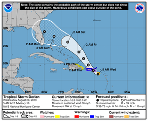
Welp, they updated models because Dorian keeps tracking further north. Will hit Puerto Rico as a TS which considering how precarious the electric grid is, its only small amount of relief. still lots of blue tarps there.

They're now predicting a Cat2 to hit Florida somewhere between Jacksonville and Vero Beach though its still pretty uncertain exactly WHERE, that cone means it could be anywhere. Still means that anyone below that should prepare of course. The only thing I need are a few pieces of wood to brace the fence gates and get a little gas (thats todays chore)

For those who aren't aware we've gotten a lot of rain (more than normal) in South Florida so the ground is pretty saturated. Last few days I've seen crews cleaning the lagoons and drain gates around here so they don't get flooded (all the lagoons here flow east to the ocean, so cleaning the lagoons and drain gates are a must!) An addition of more rain and some wind? yeah should be beautiful.:roll2:
My friends north of me are pretty worried with this new forecast.

Of course, any further north and its gonna be in Georgia at this point.

https://www.nhc.noaa.gov/text/refresh/MIATCPAT5+shtml/280848.shtml? New forecast comes out at 0800 so will update the thread if there's anything significant.

Dorian084950_5day_cone_no_line_and_wind.png
 

Arcadian

Ideal_Rock
Premium
Joined
Sep 17, 2008
Messages
9,091
For now I'm going to scale back to about friday on updates. If anyone is planning on traveling to the islands, cancel now. Trying to leave out of Florida to any island is going to NOT happen. Talk to travel agent/airlines/cruise company to see if you can get waivered to another ship or, reschedule without penalty. If coming down here always have trip insurance during hurricane season is the motto.

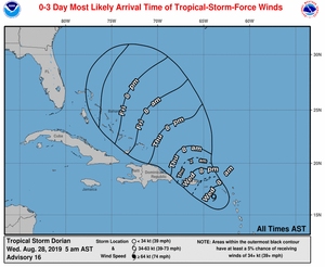
114938_most_likely_toa_no_wsp_34.png


Also keep in mind that the model at the moment is changing daily. There's talk that they could scale upwards.
 

Arcadian

Ideal_Rock
Premium
Joined
Sep 17, 2008
Messages
9,091
No track changes but pressure is dropping and its getting. Hold on to your heads migraine sufferers!

The storm will be on the north side of Puerto Rico. I don't know how much of a hit the island will take. Even if it stays offshore it will be the sustained winds and rain will be bad.

Winds from what I saw are now 70MPH and there's very good formation.

For those who are interested in whats happening in San Juan
https://www.weather.gov/sju/
A bit more granular info
https://forecast.weather.gov/MapCli...te=SJU&textField1=18.4084&textField2=-66.0644


San Juan airport status
https://www.flightstats.com/v2/airp...709d:-3ce3&utm_medium=cpc&utm_campaign=weblet

Departures and arrivals
https://www.san-juan-airport.com/departures.php
 

Tekate

Ideal_Rock
Premium
Joined
May 11, 2013
Messages
7,570
Thank you for the update Aracadian.
 

Arcadian

Ideal_Rock
Premium
Joined
Sep 17, 2008
Messages
9,091
Dorian is now a hurricane sitting at 75MPH and 997 MB so shit is getting real.
From the hurricane center

At 200 PM AST (1800 UTC), the center of Hurricane Dorian was located
near latitude 18.3 North, longitude 65.0 West. Dorian is moving
toward the northwest near 13 mph (20 km/h), and this motion is
expected to continue for the next day or two. On this track, Dorian
should continue to move near or over the U.S. and British Virgin
Islands this afternoon and then move over the open Atlantic well
east of the southeastern Bahamas.

Maximum sustained winds have increased to near 75 mph (120 km/h)
with higher gusts. Dorian is forecast to continue strengthening
during the next few days over the Atlantic waters.

Hurricane-force winds extend outward up to 20 miles (30 km) to the
north and east of the center. Tropical-storm-force winds extend
outward up to 80 miles (130 km) primarily to the east of the center.
An elevated weather station on Buck Island just south of St. Thomas
reported a sustained wind of 82 mph (132 km/h) and a gust of 111 mph
(178 km/h).

The estimated minimum central pressure from nearby observations is
997 mb (29.44 inches).

I won't post graphs or anything until after 5pm, I've got a meeting in 15 minutes(lol)
 

HS4S_2

Brilliant_Rock
Premium
Joined
May 23, 2017
Messages
1,909
I feel like Mike always has the best information. He seems tends to be very accurate. We are also on the East Coast of Florida and have been close to center of the track. I believe it shifted a little more South again but I will be watching closely. My two older boys are at University in Tampa so we are watching that area too if it crosses over. Stay safe!
I live at the beach on the east coast of Florida. My DH just asks to let him know when to pack.

This is the best page to all important links. https://spaghettimodels.com/

The page creator’s Facebook “Mike’s Weather Page” is a great resource for those obsessed.
 

HS4S_2

Brilliant_Rock
Premium
Joined
May 23, 2017
Messages
1,909
Tomorrow mornings forecast models will be very telling. We have horses so it's always stressful.

Dorian is now a hurricane sitting at 75MPH and 997 MB so shit is getting real.
From the hurricane center

At 200 PM AST (1800 UTC), the center of Hurricane Dorian was located
near latitude 18.3 North, longitude 65.0 West. Dorian is moving
toward the northwest near 13 mph (20 km/h), and this motion is
expected to continue for the next day or two. On this track, Dorian
should continue to move near or over the U.S. and British Virgin
Islands this afternoon and then move over the open Atlantic well
east of the southeastern Bahamas.

Maximum sustained winds have increased to near 75 mph (120 km/h)
with higher gusts. Dorian is forecast to continue strengthening
during the next few days over the Atlantic waters.

Hurricane-force winds extend outward up to 20 miles (30 km) to the
north and east of the center. Tropical-storm-force winds extend
outward up to 80 miles (130 km) primarily to the east of the center.
An elevated weather station on Buck Island just south of St. Thomas
reported a sustained wind of 82 mph (132 km/h) and a gust of 111 mph
(178 km/h).

The estimated minimum central pressure from nearby observations is
997 mb (29.44 inches).

I won't post graphs or anything until after 5pm, I've got a meeting in 15 minutes(lol)
 

Arcadian

Ideal_Rock
Premium
Joined
Sep 17, 2008
Messages
9,091
I live at the beach on the east coast of Florida. My DH just asks to let him know when to pack.

This is the best page to all important links. https://spaghettimodels.com/

The page creator’s Facebook “Mike’s Weather Page” is a great resource for those obsessed.

I hope you're prepared considering what they're saying today.

I went to the gas station after my meeting today, just needed some gas as my car is not the most efficient (I do love it though....lol). It was busier than normal, and of course wouldn't be South Florida without someone trying to sell you a hot car radio:lol-2::roll2:

@HS4S_2 Glad you checked in and I was gonna ask where you were.

So basically models are saying a major hurricane, meaning at least a Cat 3 hitting Florida. The weather chanel... pure comedy at this point. I can't take them serious. I'm listening more to either local or government channels. BTW @Mayk thanks for posting Mike's page. its weather nerds paradise....
 

PreRaphaelite

Ideal_Rock
Joined
Feb 2, 2015
Messages
3,564
Ok
By the time it gets to me, on the little peninsula to the west of Tampa, it should have dropped down to only a Cat 1. I can shelter in place for that. My buddies in Orlando might be driving north. Not sure.

I just bought a 4x4 Jeep SUV but it’s not road-ready yet! However, all the pets have carriers ready and vet records packed and all that. I don’t care about anything else when I evacuate. Well, I do bring the bling.


CC751964-D07B-40C7-8519-1D71529667CA.png
 

Arcadian

Ideal_Rock
Premium
Joined
Sep 17, 2008
Messages
9,091
this thing is so crazy..... I guess now they're saying it slowed down so..... my goodness this is going to be nuts.

THe track is really all over the place. I think they said that the european model has the hurricane hitting further south going across to the gulf. I guess we'll see how that really plays out.

There's an 11am forecast coming up, will not post anything until then.
 

Arcadian

Ideal_Rock
Premium
Joined
Sep 17, 2008
Messages
9,091
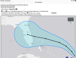
I looked at 3 possibilities on this storm (they really are all over the place. In one scenario it puts it right between West Palm Beach and Miami . That would be the worst hit for me as it puts it on my front door. Then it gets another chance to live and hits the gulf where a 2nd strike is possible.

2nd scenario is it hits closer to Port Canaveral and goes inland over Georgia and possibly stalls. Bad for the folks inland as they've been getting soaked too.

3rd scenario is that it goes up the coast and possibly hits the Carolinas (or misses, never know)

None of these are right, none of them are wrong. All three play off the high pressure dome and the low pressure domes which is what will do all the steering on this train wreck.

What I'm seeing most used is the European model which uses the first scenario and thats the one that NHC is showing here

These are the 3 day predictions
144746_3day_cone_no_line_and_wind.png

144746_earliest_reasonable_toa_no_wsp_34.png
 
  • Like
Reactions: AV_

Arcadian

Ideal_Rock
Premium
Joined
Sep 17, 2008
Messages
9,091
@Arcadian so at this point what are your plans?
I've always hauled @ss north until this year.

Hurricane Party? :mrgreen2::lol-2: I'm behind Evac Zone E so we're good. Seriously though, I'm sitting behind 2 freeway walls (I'm right in the shadow of 95) which really protects this very tiny part of the world. I'm much more worried about some of my neighbors being without electricity and the possibility of serious roof damage. The good is if we had to go to a shelter, there's one 6 blocks away (the local high school) even better the wally world parking lot west of us.

My friends further north are in much worse area than I am (Evac Zone B!) Some have already left the state. One or 2 have not yet left yet but they plan on going west.

All my friends on palm beach are gone. The ones in Boca and Ft Lauderdale are still around and both are in Evac Zone B. One couple is packing up and leaving tomorrow. The other one...they're being stupid but hey....
 

whitewave

Super_Ideal_Rock
Premium
Joined
Feb 29, 2012
Messages
12,330
I hope it’s not like Andrew where it plows over Florida and hits elsewhere in the gulf. (Like Louisiana)
 

monarch64

Super_Ideal_Rock
Premium
Joined
Aug 12, 2005
Messages
19,280
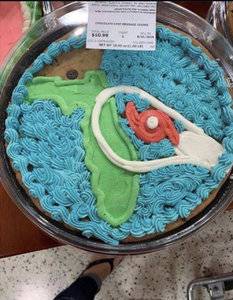
A67C4441-9BA8-4AC4-8EC8-4BBC1DDCAC82.jpeg

I don’t mean to make light of those in potential danger but
1. The drawing of Dorian’s probable impact looks like a penis and scrotum.
2. See image of cookie cake.

Hope everyone comes out in one piece.
 

Attachments

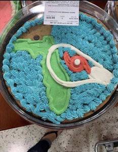
  • 2C8B0AD8-95CE-494E-B212-A4B8D06F514E.jpeg
    2C8B0AD8-95CE-494E-B212-A4B8D06F514E.jpeg
    266.9 KB · Views: 81

Arcadian

Ideal_Rock
Premium
Joined
Sep 17, 2008
Messages
9,091
A67C4441-9BA8-4AC4-8EC8-4BBC1DDCAC82.jpeg

I don’t mean to make light of those in potential danger but
1. The drawing of Dorian’s probable impact looks like a penis and scrotum.
2. See image of cookie cake.

Hope everyone comes out in one piece.

:razz::lol: please light is good. Very tense down here most are keeping it cool but I've seen some tempers flare on the roadways. Waiting on the 5am but spagetti models puts the hit very close to port st lucie/ft pierce area.
 

autumngems

Ideal_Rock
Premium
Joined
Jul 24, 2003
Messages
2,601
My husband was looking at "Windy" website/app and it has the storm going through FL then up north and back over to east coast by next Fri/Sat. I sincerely hope not, after Florence last year and not being able to get back to my home for 2 weeks I have had enough.
https://embed.windy.com/
 

PreRaphaelite

Ideal_Rock
Joined
Feb 2, 2015
Messages
3,564
I suspect it will hit Port St Lucie as a Cat 3, and drop to a Cat 1 within 12 hours as it works its way toward Orlando. After that, the only concern will be people without power which means no A/C and no refrigeration for food. If I lose power over here on the eastern coast, it will be dangerous for my cats. I'm going up to fill up my gas tank today, not for evacuation, but for a/c for the cats if it gets really bad.

We went to Sam's club last night and all the water and generators and propane were gone.
 

whitewave

Super_Ideal_Rock
Premium
Joined
Feb 29, 2012
Messages
12,330
If it comes here, at least I have a generator and can run my freezer. I just bought 12 packs of crawfish tails from my friend’s parents’ farm down in south Louisiana.

Otherwise, it would be a crawfish extravaganza. 12 packs would make a lot of ettouffe etc.
 
Be a part of the community Get 3 HCA Results
Top