shape
carat
color
clarity

The Atlantic is awake! - Fred (potentially)

Arcadian

Ideal_Rock
Premium
Joined
Sep 17, 2008
Messages
9,091
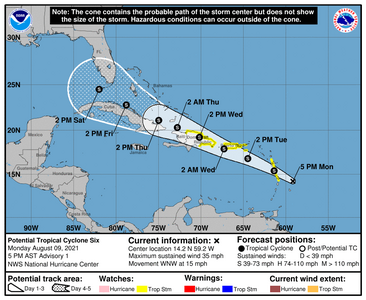
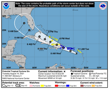
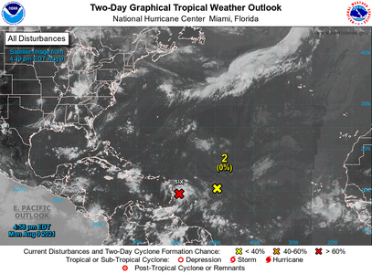
The next named storm is Fred. And things are looking mighty healthy.
by the models could be an all FL storm but one never knows... So far the guidance as been "we're going to call it but not just yet" Potential Fred is (currently named Six) is kind of interesting. I'm still learning some of this stuff but basically, it doesn't have enough circulation. I remember when that happened with Irma. And Irma was a beast.
08-9-2020two_atl_2d01.png


210624_5day_cone_no_line_and_wind.png
 

Mayk

Ideal_Rock
Premium
Joined
Feb 12, 2011
Messages
4,773
Let’s Just hope it crosses the mountains and gets broken up. If it sneaks past them in tact and gets into the gulf it will strengthen. The gulf is like a hot tub right now a lot of fuel.

On Facebook follow “Mike’s Weather Page” or spaghettimodels dot com.

Im on the Northeast Coast (.5 mile to the beach). Watching closely.
 

elizat

Ideal_Rock
Joined
Mar 23, 2013
Messages
4,000
I'm glad I emailed my tree guy for trimming today. Get everything low hanging up, stuff away from the roof and any loose bits that will detach gone .
 

Arcadian

Ideal_Rock
Premium
Joined
Sep 17, 2008
Messages
9,091
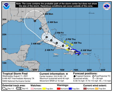
Hurricane Hunters have been out and they're finding the signs of six becoming Fred.

Center is moving closer to FL. I'm on the east coast which means, its gonna be a bit sloppy over there

Some models are showing Fred to hit lower east side of FL by Miami but no agreement on that at this current time.

Still center is moving closer to FL. Also, Floribama needs to pay very close attention as well.
145238_5day_cone_no_line_and_wind.png
 

tyty333

Super_Ideal_Rock
Premium
Joined
Dec 17, 2008
Messages
27,278
Oh, yea...another cluster...of storms:confused2:.

Seriously, thanks for the update @Arcadian . Hope you're feeling ok? Any news?
 

Arcadian

Ideal_Rock
Premium
Joined
Sep 17, 2008
Messages
9,091
Oh, yea...another cluster...of storms:confused2:.

Seriously, thanks for the update @Arcadian . Hope you're feeling ok? Any news?

I'm doing OK. I'm really bored...lol but I'm glad I don't have to seriously concentrate on work! No news yet. Thank you for asking.

I'm sincerely hoping for no development. I don't need more to worry about!
 

tyty333

Super_Ideal_Rock
Premium
Joined
Dec 17, 2008
Messages
27,278
I hear ya @Arcadian ! I know you are in the hurry up and wait mode. Fingers still crossed for you! Even if its not covid
it doesn't sound very pleasant.

On the hurricane front...
We've had so many new people move to the state I fear the first big hurricane. Its going to be chaos...more so than the usual.;(

Hopefully, we'll just get a lot of little storms/depressions/cat 1s that burn off the heat and keep the larger hurricanes from
forming (one can dream right???)
 

Arcadian

Ideal_Rock
Premium
Joined
Sep 17, 2008
Messages
9,091
We got Fred and Fred has a friend behind him. Great, they're making a train now.

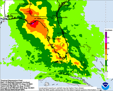
In the meantime, Fred is going to be quite the rain maker as numbers will be high in SoFL and if the GFS is to be believed it looks to be coming onshore in the pan handle.
115739_5day_cone_no_line_and_wind.png
 

Arcadian

Ideal_Rock
Premium
Joined
Sep 17, 2008
Messages
9,091
https://www.tropicaltidbits.com/recon/

763
WTNT41 KNHC 120835
TCDAT1

Tropical Depression Fred Discussion Number 11
NWS National Hurricane Center Miami FL AL062021
500 AM EDT Thu Aug 12 2021

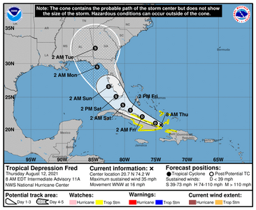
The rugged terrain of Hispaniola has taken a toll on Fred.
Satellite images and surface observations indicate that the
circulation is stretched out and seems to resemble a trough at the
surface. The system is now emerging back over water and is located
between Haiti, eastern Cuba, and the southeastern Bahamas. Most of
the associated showers and thunderstorms are located to the east of
the estimated center, with heavy rains continuing over portions of
Hispaniola. The initial intensity is estimated to be 30 kt, but
there is limited data to confirm this. Both the NOAA and Air Force
Hurricane Hunters will be investigating Fred later this morning, and
the data from both planes will be helpful in estimating Fred's
strength and structure.


Fred appears to be moving west-northwestward at about 14 kt. The
track forecast reasoning has not changed much. A subtropical
ridge currently situated to the north of Fred over the western
Atlantic should continue to steer the system west-northwestward for
the next 36 to 48 hours. This motion should take the storm just
north of or across Cuba and the southeastern Bahamas during that
time period. By the weekend, the models suggest that Fred will
be rounding the western periphery of the ridge, which will likely a
cause a slow down and a gradual turn to the northwest and then the
north across portions of the Florida Keys, the Florida peninsula,
and the eastern Gulf of Mexico. There is uncertainty in exactly
where and when Fred will make that turn to the right, with models
currently spanning a region from over Florida to the east-central
Gulf of Mexico. The NHC track forecast remains on the right side
of the guidance envelope, near the typically more skillful global
models and consensus aids.


Fred is currently in an environment of about 20 kt of westerly
vertical wind shear. This shear is expected to persist during the
next day or so, and those unfavorable winds combined with some land
interaction with Cuba should prevent the system from strengthening
much, if at all, during that time period. The shear could lessen on
Friday and since SSTs are very warm and there is abundant
environmental moisture, some strengthening seems likely when Fred is
approaching the Florida Keys and south Florida Friday night and
Saturday. After that time, the intensity forecast becomes more
complicated by how much land interaction there will be with Florida.
Since the official forecast shows a track over the eastern Gulf,
additional strengthening is predicted before Fred makes its final
landfall along the Florida Big Bend region or Florida panhandle late
in the weekend or early next week. However, that part of the
intensity forecast, since it will be very track dependent, is more
uncertain.


KEY MESSAGES:

1. Continued heavy rainfall today could lead to flash, urban, and
small stream flooding, along with possible rapid river rises and
potential mudslides in the Dominican Republic and Haiti.

2. Tropical storm conditions are possible in northern Haiti
and the southeastern Bahamas this morning, and in portions of Cuba
later today.

3. Beginning Friday, heavy rainfall could lead to areal, urban, and
small stream flooding, and possible rapid river rises across
southern Florida. Heavy rainfall associated with Fred will impact
the remainder of Florida and parts of the Southeast this weekend
and into next week.

4. There is a risk of tropical storm conditions beginning early
Saturday in the Florida Keys and south Florida. These conditions
are expected to spread northward along portions of the Florida
west coast and the Florida Panhandle through Monday.


FORECAST POSITIONS AND MAX WINDS

INIT 12/0900Z 20.2N 73.5W 30 KT 35 MPH
12H 12/1800Z 21.0N 75.1W 30 KT 35 MPH
24H 13/0600Z 22.0N 77.2W 30 KT 35 MPH
36H 13/1800Z 23.0N 79.1W 35 KT 40 MPH
48H 14/0600Z 23.8N 80.3W 35 KT 40 MPH
60H 14/1800Z 25.1N 81.4W 40 KT 45 MPH
72H 15/0600Z 26.6N 82.6W 45 KT 50 MPH
96H 16/0600Z 29.5N 84.4W 50 KT 60 MPH
120H 17/0600Z 32.2N 84.7W 35 KT 40 MPH...INLAND

$$
Forecaster Cangialosi


114831_5day_cone_no_line_and_wind.png
 

tyty333

Super_Ideal_Rock
Premium
Joined
Dec 17, 2008
Messages
27,278
Well, it looks like Sunday/Monday are probably going to be sloppy days for us.

Saw your update on the other thread. Do take care of yourself. So glad you are vaccinated. Cant imagine how
bad it might be if you werent.
 

Arcadian

Ideal_Rock
Premium
Joined
Sep 17, 2008
Messages
9,091
Well, it looks like Sunday/Monday are probably going to be sloppy days for us.

Saw your update on the other thread. Do take care of yourself. So glad you are vaccinated. Cant imagine how
bad it might be if you werent.

Yes indeed. We're getting nasty storms now so for us, its all night tonight and Saturday. Further up the coast is Sunday/Monday.

The jump to the gulf though means it can strengthen before landfall (always bad) and looks like it will hit the upper Panhandle.
234109WPCQPF_sm.gif
 

missy

Super_Ideal_Rock
Premium
Joined
Jun 8, 2008
Messages
54,170
Every region has something so I realize there is no "perfect" place to live.
But oh, how I wish there was.

I hate storms.
I hate hurricanes.
I hate fires.
I hate earthquakes.
I hate mudslides.
I hate Tsunamis.
I hate floods.
I hate hailstorms.
I hate tornados.
I hate temperature extremes.

I wish there was a place that was beautiful and tranquil at the same time without natural disasters.
I wish there was a place with temps that are mild and sunny with a few days of rain and lots of sunshine most of the time.
I wish that place was affordable and within reach.

Sorry for the tangent.

@Arcadian thanks for updating us and informing us.
I hope you are feeling much better each day.
I hope your DH remains well and free of Covid 19.
 

tyty333

Super_Ideal_Rock
Premium
Joined
Dec 17, 2008
Messages
27,278
Its not even 9am and its raining here.:roll2: Its going to be a yucky weekend.
 

Arcadian

Ideal_Rock
Premium
Joined
Sep 17, 2008
Messages
9,091
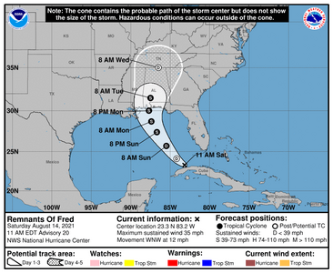
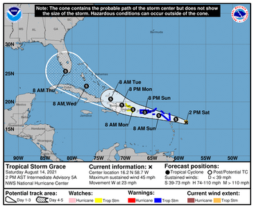
Fred will be tracking in the gulf and is currently remnants, but NHC is saying its probably going to regenerate. Grace on the other hand, is moving pretty fast and will be in the Lesser Antilles tomorrow.

Right now its very overcast. we got more from Fred last night actually.

Fred
145243_5day_cone_no_line_and_wind.png

Grace (currently model guidance is weird, way too far out to tell what its going to really do but at least one has it going into the Gulf )
175608_5day_cone_no_line_and_wind.png
 

tyty333

Super_Ideal_Rock
Premium
Joined
Dec 17, 2008
Messages
27,278
It's actually pretty nice today in my neck of the woods . It would be nice to get through the day without rain. That's probably
wishful thinking!

I'll have to check in with my parents. They live further north and on the other side of the state.

Hopefully, Grace will take it easy on us too!
 

Arcadian

Ideal_Rock
Premium
Joined
Sep 17, 2008
Messages
9,091
It's actually pretty nice today in my neck of the woods . It would be nice to get through the day without rain. That's probably
wishful thinking!

I'll have to check in with my parents. They live further north and on the other side of the state.

Hopefully, Grace will take it easy on us too!

Grace will probably miss us but she's heading to the gulf. Anything can happen there as the water is so warm.

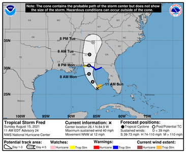
Fred came back to life and is a tropical storm and taking aim at the upper Panhandle/Floribama area.
153159_5day_cone_no_line_and_wind.png
 

Mayk

Ideal_Rock
Premium
Joined
Feb 12, 2011
Messages
4,773
It’s going to be a long season. Two waves coming off Africa now. Look to be low riders.... which usually means the gulf.

we are still not at the peak yet of the season. :oops2:
 
Be a part of the community Get 3 HCA Results
Top