shape
carat
color
clarity

Storm (Hurricane) Milton

Arcadian

Ideal_Rock
Premium
Joined
Sep 17, 2008
Messages
9,419
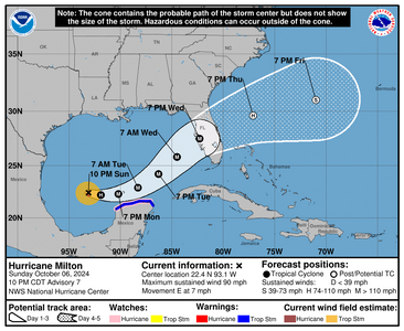
I won't even pretend this won't be a hurricane because all the model guidance is saying absolutely.

This storm comes in on the west side of FL, exits on the east. Dirty side of the storm will be south. At the moment its hard to know exactly where the eye will be. If its north of me as in, north of Lake Okeechobee, then we won't have a really rough time. If its south of the lake, its going to suck to be me!

The model guidance on this storm is interesting, because if this storm is stronger as they're thinking it will be, then the eye will be somewhere between Tampa and Big Bend area with effects still well outside of the eye. That means that Georgia and parts of SC could get more of this than they want to.

If weaker then it will pull a Hurricane Ian and come in much lower into SWFL. The eye of course can be anywhere in this cone, but with it being such a big storm, its not going to really matter for most of us.
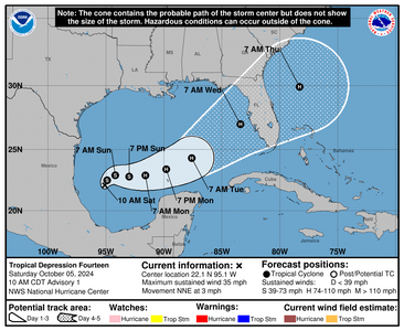
1728154639570.png

I heard that the FL National Guard has already been activated for this storm.
 
So I went to the grocery store (yes it was a little packed but probably moreso now) ...no toilet paper and very few paper towels! I guess there's some folks who thought that the dock strike was gonna take away their TP...lol I went to Home Depot and got toilet paper and paper towels instead.

I use cotton rags in place of paper towels and have sense the pandemic but with this coming, its a matter of having a 2 pack on hand, JIC.

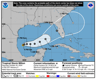
Anyway they updated the cone. Hurricane hunters will probably go out tomorrow to see whats going on.

1728161481454.png


000
WTNT44 KNHC 052046
TCDAT4

Tropical Storm Milton Discussion Number 2
NWS National Hurricane Center Miami FL AL142024
400 PM CDT Sat Oct 05 2024

Scatterometer data around midday confirmed that the circulation of
the depression was well-defined, and it also revealed peak winds of
35 kt. Based on that data, the depression was upgraded to Tropical
Storm Milton a few hours ago. The scatterometer data showed that
the center was embedded within the area of cold cloud tops, but the
area of tropical-storm-force winds was small. The overall structure
has not changed much since that time, and the initial intensity
remains 35 kt for this advisory.

Given that the system is still in its development stage, the initial
motion is a somewhat uncertain 020/3 kt. Milton is not expected to
move much through tonight, but it should begin to move eastward to
east-northeastward on Sunday as a shortwave trough drops southward
over the northwestern Gulf of Mexico. On Monday, Milton should begin
to track a little faster toward the east or east-northeast as it
moves ahead of another mid-latitude trough approaching the
southeastern United States. This trough is expected to cause Milton
to further accelerate northeastward by Tuesday night with the center
approaching the west coast of Florida. The overall track guidance
envelope has nudged northward this cycle and it should also be noted
that there remains large along-track or timing differences in the
various dynamical models. The updated official forecast is slightly
north of the previous track and is a little slower to be in better
agreement with the latest multi-model consensus aids. Users are
again reminded to not focus on the exact forecast track or timing at
the longer range as the average NHC 4-day track error is about 150
miles.

Milton is within favorable atmospheric and oceanic conditions for
strengthening. The scatterometer data indicated that the radius of
maximum was around 20 n mi, and with the expected low vertical wind
shear conditions, steady to rapid strengthening appears likely
during the next few days. The official intensity forecasts calls
for Milton to become a hurricane in about 36 hours, and a major
hurricane by 72 hours. The regional hurricane models continue to
be quite aggressive in intensifying Milton. For now, the NHC
intensity forecast is near the multi-model consensus aids, but
upward adjustments could be required if the dynamical hurricane
models continue their trends. Regardless of the exact details of
the intensity forecast, an intense hurricane with multiple
life-threatening hazards is likely to affect the west coast
of the Florida Peninsula next week.

Key Messages:
1. Milton is forecast to quickly intensify while it moves
eastward to northeastward across the Gulf of Mexico and be at or
near major hurricane strength when it reaches the west coast of the
Florida Peninsula mid week.

2. There is an increasing risk of life-threatening storm surge and
wind impacts for portions of the west coast of the Florida
Peninsula beginning late Tuesday or Wednesday. Residents in these
areas should ensure they have their hurricane plan in place, follow
any advice given by local officials, and check back for updates to
the forecast.

3. Areas of heavy rainfall will impact portions of Florida Sunday
and Monday well ahead of Milton, with heavy rainfall more directly
related to the system expected later on Tuesday through Wednesday
night. This rainfall brings the risk of flash, urban, and areal
flooding, along with minor to moderate river flooding.


FORECAST POSITIONS AND MAX WINDS

INIT 05/2100Z 22.7N 95.5W 35 KT 40 MPH
12H 06/0600Z 22.9N 95.0W 45 KT 50 MPH
24H 06/1800Z 23.0N 94.1W 55 KT 65 MPH
36H 07/0600Z 23.0N 92.8W 70 KT 80 MPH
48H 07/1800Z 23.1N 91.2W 80 KT 90 MPH
60H 08/0600Z 23.8N 89.3W 90 KT 105 MPH
72H 08/1800Z 24.8N 87.2W 100 KT 115 MPH
96H 09/1800Z 27.7N 83.0W 100 KT 115 MPH

120H 10/1800Z 30.4N 77.0W 65 KT 75 MPH...POST-TROP/EXTRATROP

$$
Forecaster Brown
 
Oh no... as if you poor Floridians haven't already been battered! I'm so sorry to see this coming your way Arcadian.
 
If the storm moves fast, then great its better for it to zip out of here than sit and linger.

But if its moving fast it won't do as much damage as a slower system. thats where I'm hopeful.

A lot has fueled Milton and there's some hope it will weaken to some degree on approach. There's some shear that will be around in the later hours before landfall....thats a lot to be counting on as that may not happen.

As it stands no shear where it is now. So because of this, it will develop and not have the convection blow off.

Monday I'll be buttoning up my gates to the back yard and hoping I don't lose anything. I cut the trees back prior to Helene so I'm still good there. I do have to make a trip to get some rope tomorrow from the hardware store.

Anyway the discussion has been pretty interesting the last couple of storms. This time they're telling people that day 4 of the track is going to be weird.

1728184509842.png


860
WTNT44 KNHC 060233
TCDAT4

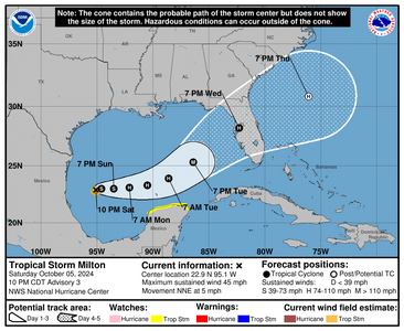
Tropical Storm Milton Discussion Number 3
NWS National Hurricane Center Miami FL AL142024
1000 PM CDT Sat Oct 05 2024

Milton appears to be slowly organizing. The storm has a central
dense overcast pattern with deep convection persisting near and to
the south of the center. The latest satellite intensity estimates
range from 30 to 50 kt, and based on that data, the initial
intensity is nudged upward to 40 kt. Milton is a small storm at the
moment, with its estimated tropical-storm-force winds extending only
about 30 n mi from the center.

The storm is moving slowly northeastward at 4 kt as it remains
embedded in weak steering currents. However, a shortwave trough is
expected to push southward into the northern Gulf of Mexico. This
trough and a reinforcing one should cause Milton to turn eastward on
Sunday, and move progressively faster to the east and then northeast
across the Gulf of Mexico and Florida during the next 3 to 4 days.
The guidance is in fair agreement, but there is some spread in
both direction and timing. Overall, the models have trended slower
this cycle, and the NHC track forecast has been adjusted in that
direction. This prediction is near the middle of the guidance
envelope and close to the typically best-performing consensus aids.
It should be noted that the average NHC track error at day 4 is
around 150 miles. Therefore, users are reminded to not focus on the
exact track.


Milton will likely steadily strengthen during the next few days as
it moves over the very warm Gulf of Mexico waters, remains in a
moist air mass, and in a diffluent and low to moderate wind shear
environment. The big question is how quickly and by how much will
the storm intensify. There is a big spread in the intensity
models, with the hurricane regional models notably above the
global and statistical-dynamical models. The new intensity
forecast is a little higher than the previous one and in good
agreement with the HCCA and IVCN aids. It is hoped that the models
will come into better agreement tomorrow after ingesting some of the
Hurricane Hunter aircraft observations.

Regardless of the details, there is increasing confidence that a
powerful hurricane with life-threatening hazards will be affecting
portions of the Florida west coast around the middle of next week.
Residents there should closely monitor this system and listen
to local officials.

Key Messages:
1. Milton is forecast to quickly intensify while it moves
eastward to northeastward across the Gulf of Mexico and be at or
near major hurricane strength when it reaches the west coast of the
Florida Peninsula mid week. Hurricane Watches could be issued as
early as late Sunday for portions of Florida.

2. There is an increasing risk of life-threatening storm surge and
wind impacts for portions of the west coast of the Florida
Peninsula beginning late Tuesday or Wednesday. Residents in these
areas should ensure they have their hurricane plan in place, follow
any advice given by local officials, and check back for updates to
the forecast.

3. Areas of heavy rainfall will impact portions of Florida Sunday
and Monday well ahead of Milton, with heavy rainfall more directly
related to the system expected later on Tuesday through Wednesday
night. This rainfall brings the risk of flash, urban, and areal
flooding, along with minor to moderate river flooding.


FORECAST POSITIONS AND MAX WINDS

INIT 06/0300Z 22.9N 95.1W 40 KT 45 MPH
12H 06/1200Z 23.0N 94.6W 50 KT 60 MPH
24H 07/0000Z 23.0N 93.5W 60 KT 70 MPH
36H 07/1200Z 23.1N 92.1W 75 KT 85 MPH
48H 08/0000Z 23.3N 90.5W 85 KT 100 MPH
60H 08/1200Z 23.9N 88.6W 95 KT 110 MPH
72H 09/0000Z 25.3N 86.4W 105 KT 120 MPH
96H 10/0000Z 28.2N 82.3W 95 KT 110 MPH
120H 11/0000Z 30.8N 76.1W 65 KT 75 MPH...POST-TROP/EXTRATROP

$$
Forecaster Cangialosi
 
We're already getting lots of rain. Smaller ditches are filling up. Unfortunately, there might be a lot of flooding by the time
Milton hits our area. I feel so bad for the Tampa area!
 
We're getting a ton of rain in FL right now because of a low that would have turned into a hurricane but didn't. So....

There's going to be a lot of wide spread flooding on this unfortunately.

Track for the eye is tightening some. Regardless of this, the peninsula is in play on this one. Panhandle is probably going to be OK as they're mostly west of the storm (until it hits the east coast that is)

Also because of this low (no named low still low) I already have a quite the head banger going on.

Also even though its raining I'm seeing and hearing a lot of birds out. I think they're mostly moving over from the west side of the state to escape.

1728233201582.png

583
WTNT44 KNHC 061458
TCDAT4

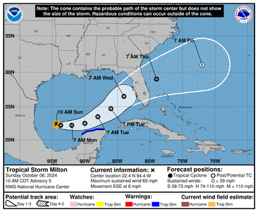
Tropical Storm Milton Discussion Number 5
NWS National Hurricane Center Miami FL AL142024
1000 AM CDT Sun Oct 06 2024

Satellite and aircraft data indicate that Milton is strengthening.
A large burst of convection is occurring in the northern semicircle
of the storm, with lots of expanding outflow. The last fix from the
NOAA Hurricane Hunter aircraft showed a pressure down to 991 mb
with maximum 500m low-level winds of about 65 kt. These winds
reduce down to the surface to about 55 kt, and this value will be
the initial intensity.


The fixes from the aircraft indicate that Milton is south of the
previously anticipated and has been moving east-southeastward or
105/5 kt. Milton is forecast to move a little south of due east
today in westerly flow from a shortwave trough over the northern
Gulf of Mexico. The storm should then turn northeastward and
accelerate on Tuesday and Wednesday toward the Florida Peninsula.
As a result of this re-positioning and initial motion, there's been
a southward change to most of the guidance this morning. The new
NHC forecast is adjusted south of the previous one, especially early
on, and further southward adjustments could be required if the
guidance trend continues.
The Mexican government has issued a
Tropical Storm Warning for the north coast of the Yucatan Peninsula
as a result of the forecast change. It should be noted that the
average NHC track error at day 3 is around 100 miles, and users
should not focus on the exact track. <--- (In other words, Naples, Venice, Fort Meyers needs to be on higher alert and anyone thats on a barrier island or immediate coastal should be ready to leave quickly)


The NOAA Hurricane Hunter crew reported that an eyewall has formed
on the last center fix, suggesting that this system is ready to
intensify quickly. Given the track over the very deep warm waters
of the Gulf of Mexico and little shear for the next couple of days,
rapid intensification is explicitly forecast, and the new NHC
prediction could still be conservative over the central Gulf of
Mexico. The biggest question actually seems to be the intensity as
Milton approaches Florida, with much of the guidance showing a
notable increase in shear. While some weakening is anticipated,
the shear could help transition Milton to be a large hurricane at
landfall, with impacts spread out over a big area. Regardless of
the details, there is increasing confidence that a powerful
hurricane with life-threatening hazards will be affecting portions
of the Florida west coast around the middle of this week.
Residents
there should closely monitor this system and listen to local
officials.


Key Messages:

1. Milton is forecast to quickly intensify while it moves eastward
to northeastward across the Gulf of Mexico and be a major hurricane
when it reaches the west coast of the Florida Peninsula mid week.
Users are reminded to not focus on the details of the forecast as
there remains significant uncertainty in the eventual track and
intensity of Milton.

2. While it is too soon to specify the exact magnitude and location
of the greatest impacts, there is an increasing risk of
life-threatening storm surge and damaging winds for portions of the
west coast of the Florida Peninsula beginning Tuesday night or early
Wednesday. Storm Surge and Hurricane Watches could be issued later
today or tonight. Residents in the Florida Peninsula should follow
any advice given by local officials and check back for updates to
the forecast.

3. Areas of heavy rainfall will impact portions of Florida today
and Monday well ahead of Milton, with heavy rainfall more directly
related to the system expected later on Tuesday through Wednesday
night. This rainfall will bring the risk of flash, urban, and areal
flooding, along with the potential of moderate to major river
flooding.

4. Tropical storm conditions are expected beginning Monday across
portions of the northern Yucatan Peninsula of Mexico where a
Tropical Storm Warning is in effect.


FORECAST POSITIONS AND MAX WINDS

INIT 06/1500Z 22.4N 94.4W 55 KT 65 MPH
12H 07/0000Z 22.2N 93.7W 65 KT 75 MPH
24H 07/1200Z 22.2N 92.0W 85 KT 100 MPH
36H 08/0000Z 22.5N 90.0W 100 KT 115 MPH
48H 08/1200Z 23.5N 88.0W 110 KT 125 MPH
60H 09/0000Z 24.7N 86.0W 110 KT 125 MPH
72H 09/1200Z 26.5N 84.0W 105 KT 120 MPH
96H 10/1200Z 29.0N 79.0W 75 KT 85 MPH
120H 11/1200Z 31.0N 72.0W 55 KT 65 MPH...POST-TROP/EXTRATROP

$$
Forecaster Blake
 
@tyty333 like you we're pretty soaked here and its only going to be worse. I'm not in a flood zone but my house is next to a canal which always has me worried.

My neighbor across the street put up halloween stuff last week, is now taking it down after we talked yesterday. No one wants to see a 13 foot skeleton go flying off.

And models are sniffing out another one right after this one...what a freaking year....
 
@Arcadian
We're not in a flood zone either but I still worry. We're right in the bulls-eye of the path at the moment...but it's early. Not so much
worried about the wind but all the rain. We're out of propane too so going to work on getting that refilled/replaced tomorrow.
It may be too late for that. I hit the grocery store this morning (it was a regular visit...not due to the storm), and it was packed!
They are out of a lot of paper products. I noticed this earlier in the week so it may be due to Hurricane Helene.

Stay dry down there...sorry to hear about your migraine.:(2 I know it's an issue for you when the barometer drops.

And No, no one wants a 13-foot skeleton flying through their living room window! :shock::lol: Good planning on your neighbor's part to
bring it down!
 
There are a lot of campers /mobile homes over here, assuming that its people from the west side looking for places to hang out and be safe.

News is saying that hotels are filling up quickly near the airport (PBI) so...gonna be interesting!

As it gets closer, I think I might not be in the cone. Not that it means much if the eyewall skirts this area. Last few model runs I've seen the eye above Lake Okeechobee

Do stay safe and check in when you can. I'd say come south but were gonna get wrecked by the feeder bands. Miami is definitely going to flood, probably parts of West Palm/Palm Beach too. Barrier Islands are gonna take the brunt per usual so there will be some hella beach erosion from this.

1728252927831.png

New discussion from 4pm


000
WTNT44 KNHC 062053
TCDAT4

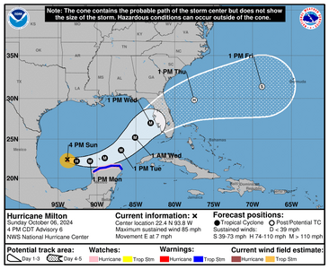
Hurricane Milton Discussion Number 6
NWS National Hurricane Center Miami FL AL142024
400 PM CDT Sun Oct 06 2024

Milton is rapidly intensifying. Satellite images indicate very
deep convection in the eyewall and hints of an eye starting to
appear. The last fix from the aircraft showed that the
central pressure was down to 985 mb, about 3 mb less than 80
minutes prior, and winds supporting 70 kt at the surface. Since
that time, satellite images continue to show further organization,
and the initial wind speed is set to 75 kt.

Milton is moving just south of due east at about 6 kt. This
equatorward motion has been more than expected probably due to a
stronger low/ mid-level frontal low over the northeastern Gulf of
Mexico. The frontal feature is forecast to weaken while it moves
across Florida and gradually lose its influence on Milton. This
evolution should allow the hurricane to turn eastward on Monday and
then accelerate to the northeast on Tuesday and Wednesday toward the
Florida Peninsula ahead of a trough moving offshore of Texas. The
NHC forecast is a bit south of the previous one through 48 hours,
following the trend of the guidance at that time, and the government
of Mexico has issued a Hurricane Watch for a portion of the northern
coast of Yucatan. Later on, the guidance is similar to, or slightly
north of the last cycle, and very little change is made to the
forecast near Florida. It should be noted that the average NHC track
error at day 3 is around 100 miles, and users should not focus on
the exact track. <---this freaks me TF out.


The intensity forecast appears straightforward at first, with rapid
intensification likely while the small hurricane remains within
light shear and over very deep warm waters. Intensity guidance is
about as bullish as I've seen in this part of the basin, with
almost everything showing a peak intensity of category 4 or 5 in
the southern Gulf of Mexico in a day or two. The NHC forecast is
raised from the previous one and lies near the intensity consensus
model and still could be too low.
Later on, vertical wind shear is
forecast to markedly increase as Milton approaches Florida, and
some weakening is anticipated. However, the regional hurricane
models are showing the system growing even if it weakens, and we are
expecting Milton to be a large hurricane at landfall, with very
dangerous impacts spread out over a big area.
There is increasing
confidence that a powerful hurricane with life- threatening hazards
will be affecting portions of the Florida west coast around the
middle of this week. Residents there should closely monitor this
system and listen to local officials.


Key Messages:

1. Milton is forecast to be a major hurricane when it reaches the
west coast of the Florida Peninsula midweek. Users are reminded to
not focus on the details of the forecast as there remains
significant uncertainty in the eventual track and intensity of
Milton.

2. While it is too soon to specify the exact magnitude and location
of the greatest impacts, there is an increasing risk of life-
threatening storm surge and damaging winds for portions of the west
coast of the Florida Peninsula beginning early Wednesday and Storm
Surge and Hurricane Watches will likely be issued tonight or early
Monday. Residents in the Florida Peninsula should follow any advice
given by local officials and monitor updates to the forecast.

3. Areas of heavy rainfall will impact portions of Florida through
Monday well ahead of Milton, with heavy rainfall more directly
related to Milton expected on Tuesday through Wednesday night. This
rainfall will bring the risk of considerable flash, urban, and areal
flooding, along with the potential for moderate to major river
flooding.

4. Tropical storm conditions are expected with hurricane conditions
possible beginning Monday across portions of the northern Yucatan
Peninsula of Mexico where a Tropical Storm Warning and Hurricane
Watch are in effect.


FORECAST POSITIONS AND MAX WINDS

INIT 06/2100Z 22.4N 93.8W 75 KT 85 MPH
12H 07/0600Z 22.2N 92.6W 90 KT 105 MPH
24H 07/1800Z 22.2N 90.9W 110 KT 125 MPH
36H 08/0600Z 22.6N 89.0W 120 KT 140 MPH
48H 08/1800Z 23.6N 86.9W 125 KT 145 MPH
60H 09/0600Z 25.2N 85.1W 120 KT 140 MPH
72H 09/1800Z 27.0N 83.1W 105 KT 120 MPH
96H 10/1800Z 29.8N 77.5W 65 KT 75 MPH...POST-TROP/EXTRATROP
120H 11/1800Z 31.4N 68.8W 55 KT 65 MPH...POST-TROP/EXTRATROP

$$
Forecaster Blake
 
51 Counties are under state of emergency. Okeechobee already has canceled classes. On the South East side where I am, I hear that most county schools will be in session tomorrow.

Adding the news writeup. Please keep any comments non political, this is not the time.

Mentioned in the write up that hotels are accepting pets during this state of emergency.


Alachua
Baker
Bradford
Brevard
Broward
Charlotte
Citrus
Clay
Collier
Columbia
DeSoto
Dixie
Duval
Flagler
Gilchrist
Glades

Hamilton
Hardee
Hendry
Hernando
Highlands
Hillsborough
Indian River
Lafayette
Lake
Lee
Levy
Madison
Manatee
Marion
Martin
Miami-Dade
Monroe
Nassau
Okeechobee
Orange
Osceola
Palm Beach
Pasco
Pinellas
Polk
Putnam
Sarasota
Seminole
St. Johns
St. Lucie
Sumter
Suwanee
Taylor
Union
Volusia

Shelters. If you know someone in any of these counties that may be looking for shelter, this is probably your best bet. Pets can be with you as long as they're on their best behavior around people.


In addition to this. Some places like Walmart do allow campers and mobile homes in their parking lots.
 
Last edited:
1728275389969.png


349
WTNT44 KNHC 070242
TCDAT4

Hurricane Milton Discussion Number 7
NWS National Hurricane Center Miami FL AL142024
1000 PM CDT Sun Oct 06 2024

Milton continues to intensify. The hurricane's center is embedded
within a circular Central Dense Overcast containing very intense
convection with cloud tops colder than -80 deg C. Tail Doppler wind
data from the NOAA Hurricane Hunter aircraft show that the
circulation is quite symmetric, with very little vertical tilt from
1 to 5 km elevation. Observations from both Air Force and NOAA
Hurricane Hunters indicate that the central pressure is falling and
that the intensity has increased to near 80 kt.


Fixes from the aircraft and satellite imagery indicate that the
hurricane is moving generally eastward with an initial motion
estimate of 100/6 kt. Milton is moving within the southern portion
of a broad mid-level trough over the Gulf of Mexico, and is also
being influenced by the flow on the southwest side of a low- to
mid-level cyclone currently over the eastern Gulf. The
numerical guidance indicates that this cyclone will shift east
of Florida within the next day or two, so that its influence
on Milton will gradually lessen with time. As the mid-level
trough digs over the central Gulf, the hurricane should turn
northeastward with some increase in forward speed during the
next 2-3 days and be near the west coast of Florida in the 72
hour time frame. After crossing Florida, the cyclone should turn
east-northeastward to eastward over the Atlantic waters off the
southeastern United States. The official track forecast follows
essentially the same trajectory as the previous NHC prediction but
is a bit slower, in accordance with the latest dynamical model
consensus guidance. Again it should be noted that the average NHC
track error at day 3 is around 100 miles, and users should not focus
on the exact track.


Milton should continue to traverse waters of very high oceanic heat
content within an environment of light vertical wind shear and moist
low- to mid-level air for the next 1-2 days. The official intensity
forecast is similar to the previous one and shows Milton rapidly
strengthening to category 4 intensity within the next couple of
days. Thereafter, stronger upper-level westerlies over the northern
Gulf of Mexico should result in increasing shear.
The latest SHIPS
model output shows the shear over Milton increasing significantly in
60-72 hours. Therefore, some weakening is anticipated before the
hurricane reaches the Florida Gulf coast. However, the system is
still likely to be a large and powerful hurricane at landfall in
Florida, with life-threatening hazards along portions of the the
coastline.


Key Messages:

1. Milton is forecast to be a major hurricane when it reaches the
west coast of the Florida Peninsula by midweek. Users are reminded
to not focus on the details of the forecast as there remains
significant uncertainty in the eventual track and intensity of
Milton.

2. While it is too soon to specify the exact magnitude and location
of the greatest impacts, there is an increasing risk of life-
threatening storm surge and damaging winds for portions of the west
coast of the Florida Peninsula beginning early Wednesday and Storm
Surge and Hurricane Watches will likely be issued early Monday.
Residents in the Florida Peninsula should follow any advice given
by local officials and monitor updates to the forecast.

3. Areas of heavy rainfall will impact portions of Florida Monday
well ahead of Milton, with heavy rainfall more directly related to
the system expected later on Tuesday through Wednesday night. This
rainfall brings the risk of considerable flash, urban, and areal
flooding, along with the potential for moderate to major river
flooding.

4. Tropical storm conditions are expected with hurricane conditions
possible beginning Monday across portions of the northern Yucatan
Peninsula of Mexico where a Tropical Storm Warning and Hurricane
Watch are in effect.


FORECAST POSITIONS AND MAX WINDS

INIT 07/0300Z 22.4N 93.1W 80 KT 90 MPH
12H 07/1200Z 22.2N 91.9W 95 KT 110 MPH
24H 08/0000Z 22.3N 90.2W 110 KT 125 MPH
36H 08/1200Z 22.9N 88.3W 125 KT 145 MPH
48H 09/0000Z 24.2N 86.3W 125 KT 145 MPH
60H 09/1200Z 25.8N 84.5W 115 KT 130 MPH
72H 10/0000Z 27.5N 82.3W 100 KT 115 MPH...INLAND
96H 11/0000Z 29.6N 77.1W 65 KT 75 MPH...POST-TROP/EXTRATROP
120H 12/0000Z 31.0N 71.0W 50 KT 60 MPH...POST-TROP/EXTRATROP

$$
Forecaster Pasch
 
I am so sorry about Milton and keeping everyone affected in my thoughts and prayers.
May he calm down soon and may everyone stay safe
 
Milton wants his stapler back...apparently. (I don't watch the show, I just keep seeing the memes)
 
Milton has some cat 5 realness. There has been some serious cone shifts. Just means the eye is going to not be over my house but be over someone elses. Also doesn't mean there will not be dangerous and catastrophic weather outside the eye either. We don't have watches and warnings on the east coast yet but they are coming.

I'm very genuinely worried about what I'm seeing and what this means for the state and the people that live here. They're finding 940's already in this thing.

Hurricane Hunters are out! https://www.tropicaltidbits.com/recon/

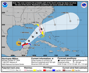
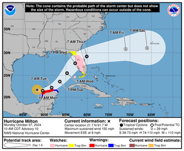
The official cone
1728303861927.png


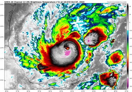
IR loop from tropicaltidbits
1728304085687.jpeg


000
WTNT44 KNHC 071149
TCDAT4

Hurricane Milton Special Discussion Number 9
NWS National Hurricane Center Miami FL AL142024
700 AM CDT Mon Oct 07 2024

Recent data from both NOAA and Air Force Hurricane Hunter aircraft
indicate that Milton continues to rapidly strengthen.
The Air
Force aircraft very recently reported a peak flight-level wind of
120 kt, and dropsonde data show that the pressure has fallen to
around 945 mb, which is down about 9 mb from a previous dropsonde
report from the NOAA aircraft about an hour ago. This special
advisory is being issued to increase the initial intensity to
110 kt, and to increase the short term intensity forecast that now
shows a peak wind speed of 135 kt in 24 hours.


The aircraft fixes were also a little south of the previous
forecast track and a southward adjustment to the official track
forecast has been made through 36 hours. Hurricane-force winds
are explicitly forecast to affect the northern coast of Yucatan,
and residents in that area should rush preparations to completion.
The updated track forecast has necessitated the government of Mexico
to issue a Tropical Storm Warning and Hurricane Watch from Celestun
southward to Campeche. The storm surge forecast has been increased
to 3 to 5 feet above ground level for portions of the northern coast
of the Yucatan Peninsula.


No changes to the NHC track or intensity forecast were made after
36 hours.

This special advisory was issued in lieu of the normal intermediate
advisory.

Key Messages:

1. Dangerous hurricane-force winds are expected across portions of
the northern coast of the Yucatan Peninsula. A life-threatening
storm surge with damaging waves is also likely along portions of
the northern coast of the Yucatan Peninsula.

2. There is an increasing risk of life-threatening storm surge and
damaging winds for portions of the west coast of the Florida
Peninsula beginning Tuesday night or early Wednesday. Storm Surge
and Hurricane Watches are now in effect for portions of the west
coast of the Florida Peninsula and residents in that area should
follow any advice given by local officials and evacuate if told to
do so.

3. Areas of heavy rainfall will impact portions of Florida today
well ahead of Milton, with heavy rainfall more directly related to
the system expected later on Tuesday through Wednesday night. This
rainfall will bring the risk of considerable flash, urban, and
areal flooding, along with the potential for moderate to major
river flooding.


FORECAST POSITIONS AND MAX WINDS

INIT 07/1200Z 21.8N 92.2W 110 KT 125 MPH
12H 07/1800Z 21.6N 91.5W 125 KT 145 MPH
24H 08/0600Z 21.8N 89.3W 135 KT 155 MPH
36H 08/1800Z 22.9N 87.5W 130 KT 150 MPH
48H 09/0600Z 24.7N 85.7W 125 KT 145 MPH
60H 09/1800Z 26.4N 83.9W 110 KT 125 MPH
72H 10/0600Z 28.1N 81.7W 75 KT 85 MPH...INLAND
96H 11/0600Z 30.0N 75.5W 55 KT 65 MPH...POST-TROP/EXTRATROP
120H 12/0600Z 31.5N 68.4W 45 KT 50 MPH...POST-TROP/EXTRATROP

$$
Forecaster Blake/Brown
 
The Saffir-Simpson Hurricane Wind Scale is a 1 to 5 rating based only on a hurricane's maximum sustained wind speed. This scale does not take into account other potentially deadly hazards such as storm surge, rainfall flooding, and tornadoes.

The Saffir-Simpson Hurricane Wind Scale estimates potential property damage. While all hurricanes produce life-threatening winds, hurricanes rated Category 3 and higher are known as major hurricanes*. Major hurricanes can cause devastating to catastrophic wind damage and significant loss of life simply due to the strength of their winds. Hurricanes of all categories can produce deadly storm surge, rain-induced floods, and tornadoes. These hazards require people to take protective action, including evacuating from areas vulnerable to storm surge.

*In the western North Pacific, the term "super typhoon" is used for tropical cyclones with sustained winds exceeding 150 mph.


Cat 1 74-95 mph 64-82 kt 119-153 km/h
Very dangerous winds will produce some damage: Well-constructed frame homes could have damage to roof, shingles, vinyl siding and gutters. Large branches of trees will snap and shallowly rooted trees may be toppled. Extensive damage to power lines and poles likely will result in power outages that could last a few to several days.


Cat 2 96-110 mph 83-95 kt 154-177 km/h
Extremely dangerous winds will cause extensive damage: Well-constructed frame homes could sustain major roof and siding damage. Many shallowly rooted trees will be snapped or uprooted and block numerous roads. Near-total power loss is expected with outages that could last from several days to weeks.


Cat3 (major) 111-129 mph 96-112 kt 178-208 km/h
Devastating damage will occur: Well-built framed homes may incur major damage or removal of roof decking and gable ends. Many trees will be snapped or uprooted, blocking numerous roads. Electricity and water will be unavailable for several days to weeks after the storm passes.


Cat4 (major) 130-156 mph 113-136 kt 209-251 km/h
Catastrophic damage will occur: Well-built framed homes can sustain severe damage with loss of most of the roof structure and/or some exterior walls. Most trees will be snapped or uprooted and power poles downed. Fallen trees and power poles will isolate residential areas. Power outages will last weeks to possibly months. Most of the area will be uninhabitable for weeks or months.


Cat5 (major) 157 mph or higher 137 kt or higher 252 km/h or higher Catastrophic damage will occur: A high percentage of framed homes will be destroyed, with total roof failure and wall collapse. Fallen trees and power poles will isolate residential areas. Power outages will last for weeks to possibly months. Most of the area will be uninhabitable for weeks or months.
 
Milton is a Cat 5.
1728318729089.png

567
WTNT64 KNHC 071558 CCA
TCUAT4

Hurricane Milton Tropical Cyclone Update...Corrected
NWS National Hurricane Center Miami FL AL142024
1055 AM CDT Mon Oct 07 2024

Corrected for location/distances in the summary section

...MILTON RAPIDLY INTENSIFIES INTO A CATEGORY 5 HURRICANE...

Data from an Air Force Reserve Hurricane Hunter aircraft indicate
that Milton has strengthened to a category 5 hurricane. The
maximum sustained winds are estimated to be 160 mph (250 km/h) with
higher gusts. Data from the aircraft also indicate that the
minimum pressure has fallen to 925 mb (27.31 inches).


SUMMARY OF 1055 AM CDT...1555 UTC...INFORMATION
-----------------------------------------------
LOCATION...21.7N 91.6W
ABOUT 125 MI...200 KM WNW OF PROGRESO MEXICO
ABOUT 715 MI...1150 KM SW OF TAMPA FLORIDA
MAXIMUM SUSTAINED WINDS...160 MPH...250 KM/H
PRESENT MOVEMENT...ESE OR 110 DEGREES AT 9 MPH...15 KM/H
MINIMUM CENTRAL PRESSURE...925 MB...27.31 INCHES

$$
Forecaster Blake/Brown
 
We are currently getting ready for Milton. Looks to be exiting right over us. Crazy storm progression. We have a lot of first responsers in the family and are being activated for the storm and will be on 72 hours mandatory shifts. Horses being moved. Please be safe Florida members.
 
Keeping everyone who will be affected by this storm in my thoughts. Stay safe all <3
 
Everything crossed for your safety.
 
@Arcadian What does this mean?

940mb of atmospheric pressure its another indicator of hurricane strength.
Barometric pressure is another way its measured.
The lower the pressure the more powerful the storm.
940 is in the extreme category aka 4.
A storm can have category 5 winds and category 4 pressure.
Changes in pressure are an indicator of what the storm is doing.
up - storm is decreasing
down - storm is increasing
 
Last edited:
my prayers go out for everyone in the path of this storm!
 
180MPH winds...

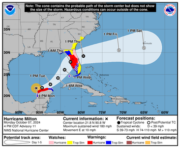
1728336310094.png

000
WTNT44 KNHC 072058
TCDAT4

Hurricane Milton Discussion Number 11
NWS National Hurricane Center Miami FL AL142024
400 PM CDT Mon Oct 07 2024

Satellite images indicate that Milton is quite a powerful hurricane.
The small eye has become even more distinct than earlier today, and
radar data from Sabancuy show a small, closed eye with a very
strong eyewall presentation. On the last fix before the plane
departed a few hours ago, the Air Force Hurricane Hunter crew
reported that the pressure had fallen to 911 mb, which is 77 mb
lower than yesterday at the same time, with other data to support
150 kt. Since the satellite imagery continues to show
intensification, the initial wind speed is set to 155 kt, and a pair
of Hurricane Hunters should be in the area this evening for more
information.

The hurricane is moving eastward at about 9 kt. Milton should move
close to the northern portion of Yucatan Peninsula tonight and early
Tuesday ahead of a mid-level trough dropping into the northwestern
Gulf of Mexico. This feature should then cause Milton to move
east-northeastward to northeastward at a faster forward speed
later on Tuesday and Wednesday. Little change was made to the
previous forecast, with the latest model guidance very close to the
previous forecast cycle, and this forecast remains close to a
consensus of the latest GFS, ECMWF and regional hurricane models.
Note that this track is closer to the model fields rather than the
model trackers which appear to be too far south.

Milton could strengthen even more tonight with light shear and
very warm waters providing a conducive environment. However, radar
data indicate that Milton could be at the beginning of an eyewall
replacement cycle, with some signs of a moat and a partial outer
eyewall. The evolution will likely cause the system to gradually
weaken on Tuesday but grow larger. On Wednesday, Milton is expected
to encounter a less favorable environment with strong shear and dry
air entrainment, with further weakening forecast. Regardless, the
system is expected to be a large and powerful hurricane at landfall
in Florida, with life-threatening hazards at the coastline and well
inland. Residents in Florida should closely follow the orders from
their local emergency management officials, as Milton has the
potential to be one of the most destructive hurricanes on record
for west-central Florida.


Key Messages:

1. Damaging hurricane-force winds and a life-threatening storm surge
with destructive waves are expected across portions of the northern
coast of the Yucatan Peninsula through tonight.

2. Milton is expected to grow in size and remain an extremely
dangerous hurricane when it approaches the west coast of Florida on
Wednesday. A large area of destructive storm surge will occur along
parts of the west coast of Florida on Wednesday. This is an
extremely life-threatening situation and residents in those areas
should follow advice given by local officials and evacuate
immediately if told to do so.

3. Potentially devastating hurricane-force winds are expected along
portions of the west coast of Florida where a Hurricane Warning is
in effect. Milton is forecast to remain a hurricane as it crosses
the Florida Peninsula and life-threatening hurricane-force winds,
especially in gusts, are expected to spread inland across a portion
of the entire Florida Peninsula. Preparations to protect life and
property in the warning areas should be complete by Tuesday night
since tropical storm conditions are expected to begin within this
area early Wednesday.

4. Areas of heavy rainfall will impact portions of Florida today
well ahead of Milton, with heavy rainfall more directly related to
the system expected later on Tuesday through Wednesday night. This
rainfall will bring the risk of considerable flash, urban, and areal
flooding, along with the potential for moderate to major river
flooding.

FORECAST POSITIONS AND MAX WINDS

INIT 07/2100Z 21.8N 90.8W 155 KT 180 MPH
12H 08/0600Z 21.9N 89.4W 160 KT 185 MPH
24H 08/1800Z 22.7N 87.4W 150 KT 175 MPH
36H 09/0600Z 24.2N 85.6W 140 KT 160 MPH
48H 09/1800Z 26.1N 84.0W 125 KT 145 MPH
60H 10/0600Z 27.9N 82.6W 110 KT 125 MPH...INLAND
72H 10/1800Z 29.2N 79.5W 75 KT 85 MPH...OVER WATER
96H 11/1800Z 30.5N 71.0W 55 KT 65 MPH...POST-TROP/EXTRATROP
120H 12/1800Z 31.0N 65.0W 40 KT 45 MPH...POST-TROP/EXTRATROP

$$
 
nasty it is heading towards being a chart topper.
 
We are currently getting ready for Milton. Looks to be exiting right over us. Crazy storm progression. We have a lot of first responsers in the family and are being activated for the storm and will be on 72 hours mandatory shifts. Horses being moved. Please be safe Florida members.
I'm glad you found a shelter for your horses! be safe as you can, prayers to you and your family members.
@Arcadian What does this mean?

Sorry I didn't see this until later on (trying to wrap up work stuff so I can concentrate on the dogs ...they're driving me absolutely bonkers)

MB or millibars is part of the old system when they would use millibars to give a hurricane a category. @Karl explained it well (thank you Karl!!)

This goes into much more detail

The newer Safford Simpson system uses windspeed, which you'll see here
 
Tampa International Airport (TPA) — which appears to be greatly impacted by the storm, according to tracking models— said it will close ahead of Milton's landfall. Flight operations will be suspended through 9 a.m. Tuesday. The airport did not specify whether it will reopen saying it will, "reopen when safe to do so later this week."

The three other public airports managed by the Hillsborough County Aviation Authority will also close in a similar timeframe:

  • Peter O. Knight Airport
  • Tampa Executive Airport
  • Plant City Airport
Miami International Airport (MIA), the largest airport in Florida, said it is still open on Monday and is closely monitoring Milton's track.

Orlando International Airport (MCO) said officials are meeting with partnering agencies to monitor the status of Hurricane Milton before a decision is made. Updates will be sent to its website.

Fort Lauderdale–Hollywood International Airport (FLL) said it will remain open since it's not in the direct line of the storm.

Palm Beach International Airport (PBI) said it's running normally at this time.

The Gainesville Airport told travelers to check their flight status with their airline, not the airport.

The Southwest Florida International Airport (RSW) stated it is operating normally and does notknow what impacts the hurricane may have on flights later this week.

The majority of the airports stated they will continue to monitor the storm and follow Milton's track as it moves closer to Florida's coastline. Asking travelers to check their websites and social media pages for timely updates. Each airport askstravelers to confirm their flight status with their airline for any potential delays or cancellations.
 
You guys, I'm having a mini panic attack with worry for you. I want to magic myself around and sweep you up safe.

Be safe my friends, be as safe as you can.
 
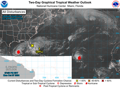
1728349175377.png

Milton has a friend.
 
GET 3 FREE HCA RESULTS JOIN THE FORUM. ASK FOR HELP
Top