- Joined
- Sep 17, 2008
- Messages
- 9,414
Oh boy! Let the fun begin. Better for us to buy a generator than another shiny thing. Hahaha! (I’m in Florida.)
This is my 13th hurricane season here and so far we have only lost power once. That’s not to say we won’t, just that we haven’t. So I think we get complacent and figure we won’t need it. But we should be better prepared for sure!Oh wow, you don't have one yet? Honestly if you don't and just want a small one, I would not wait to buy one in the crush (it always happens!) I had a fan die and am replacing it today at 3 while most folks aren't paying attention to this stuff. Then I'll go grocery shopping this evening for next week.
I typically am prepared by July, only having to replenish the basics. All the gas I purchased last year was ethanol free so should be good still.
This is my 13th hurricane season here and so far we have only lost power once. That’s not to say we won’t, just that we haven’t. So I think we get complacent and figure we won’t need it. But we should be better prepared for sure!
How often is Orlando affected by Hurricane weather?
Obviously, it's not a direct hit, but now that my daughter is living in the area, I'm wondering.
Seems like at least once in the past few years, there was a story about Disney World closing for weather related to a hurricane
How often is Orlando affected by Hurricane weather?
Obviously, it's not a direct hit, but now that my daughter is living in the area, I'm wondering.
Seems like at least once in the past few years, there was a story about Disney World closing for weather related to a hurricane
 realestateagentus.wordpress.com
Orlando can be impacted but it’s inland. So usually the storm would weaken as it goes across land. If it’s a very strong storm, it could be an issue.
I live 15 minutes inland and usually what we get isn’t quite as strong as what the coast gets. We don’t have the storm surge this far in.
Very low risk. Honestly, you'd probably just get tropical storm like weather if a storm came close enough, so just put up flying objects and keep your trees trimmed. Good advice for any storm, honestly.

Cities in Florida least affected by Hurricanes
Are you tired of long cold winters that keep you indoors most of the time? It’s unsettling to see your friends from cities that have a tropical climate enjoying sunny, warm days on the beach while …realestateagentus.wordpress.com
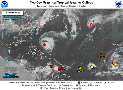
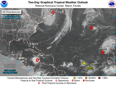
CZC MIATWOAT ALL
TTAA00 KNHC DDHHMM
Tropical Weather Outlook
NWS National Hurricane Center Miami FL
800 AM EDT Thu Sep 22 2022
For the North Atlantic...Caribbean Sea and the Gulf of Mexico:
Active Systems:
The National Hurricane Center is issuing advisories on Hurricane
Fiona, located several hundred miles southwest of Bermuda, and on
Tropical Storm Gaston, located a few hundred miles west-southwest of
the Azores.
1. Southeastern Caribbean Sea:
Showers and thunderstorms continue in association with a tropical
wave located over the southeastern Caribbean Sea. Although
upper-level winds are currently inhibiting development, the
environment is forecast to gradually become more favorable in a
couple of days, and a tropical depression is likely to form at that
time. The disturbance is forecast to move west-northwestward across
the eastern Caribbean Sea during the next day or two, and be over
the central Caribbean Sea this weekend. Regardless of development,
locally heavy rainfall and gusty winds are likely to affect the
Windward Islands, northern Venezuela, and the ABC island chain
today. These impacts are likely to spread to northeastern Colombia
later this evening.
* Formation chance through 48 hours...high...70 percent.
* Formation chance through 5 days...high...90 percent.
2. Eastern Tropical Atlantic:
Showers and thunderstorms located near the west coast of Africa are
associated with a tropical wave that has emerged over the warm
waters of the far eastern Atlantic. Environmental conditions are
forecast to be conducive for some development, and a tropical
depression could form by this weekend while the system moves slowly
northward, between west Africa and the Cabo Verde Islands.
* Formation chance through 48 hours...medium...60 percent.
* Formation chance through 5 days...medium...60 percent.
3. East Central Tropical Atlantic:
A broad area of low pressure located several hundred miles
west-southwest of the Cabo Verde Islands continues to produce
disorganized showers and thunderstorms. Despite marginal
environmental conditions, some slow development of this system is
possible over the next several days while it moves slowly
northwestward or northward over the tropical Atlantic.
* Formation chance through 48 hours...low...20 percent.
* Formation chance through 5 days...low...30 percent.
Forecaster Bucci
ZCZC MIATCDAT4 ALL
TTAA00 KNHC DDHHMM CCA
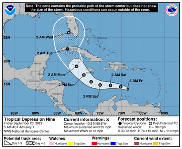
Tropical Depression Nine Discussion Number 1...Corrected
NWS National Hurricane Center Miami FL AL092022
500 AM AST Fri Sep 23 2022
Corrected locations of convection in first paragraph.
Convection this morning has increased primarily to the west of the
area of low pressure we have been monitoring in the central
Caribbean Sea, currently passing by to the north of Curacao island.
The system already possessed a well-defined circulation for the last
12 to 18 hours, but it was only overnight that the ongoing
convective activity was able to persist long enough near the center
to be considered a tropical cyclone. The most recent satellite
intensity estimate from TAFB was up to T2.5/35-kt. However the
GOES-16 derived motion winds from the meso sector over the system
have only been 25-30 kt in the 925-850 mb layer on the northeastern
periphery of the circulation. In addition, buoy 42059 located to the
northeast of the center has been reporting winds up to only 27-kt.
The combination of all these data provide enough justification to
upgrade this system to Tropical Depression Nine, with the initial
winds set at 30 kt for this advisory. An Air Force Reserve
Reconnaissance mission will be investigating the system later this
morning to provide more in-situ information of the system's
structure and intensity.
The current motion right now is estimated to be off to the
west-northwest at 290/12 kt. In the short-term, the depression is
forecast to bend back more westward as a narrow east-to-west
oriented mid-level ridge builds in behind the weakness left behind
from Fiona. The current westward displaced convection may also tug
the broad center in that direction as well. However, after 48 hours,
this ridge will start to decay as a longwave deep-layer trough over
the eastern United States begins to amplify southward. This synoptic
evolution should then allow the cyclone to begin gaining latitude,
though the exact timing at which this occurs could be somewhat
related to the vertical depth of the cyclone and how it interacts
with a weak upper-level trough expected to be over the far western
Caribbean in the day 3-4 time-frame. The model guidance early on is
in fairly good agreement, but larger across-track spread begins to
take shape by 48 hours, with the GFS and its ensemble mean located
further south and west, and with the ECMWF and its ensemble mean
located further north and east. The initial track forecast has
decided to split the difference between these two model suites, and
lies fairly close to the consensus aids TVCN and HCCA. There is
still a healthy amount of uncertainty in the track forecast at the
day 4-5 timeframe.
Currently the structure of the depression is quite disheveled, with
the low-level circulation mostly exposed, with deep convective
activity displaced to its west-southwest. This structure is due to
25-30 kt of northeasterly 200-850 mb vertical wind shear caused from
the equatorward outflow channel of Fiona, resulting in significant
upper-level flow over the system. However, as the depression moves
westward, it will move out form under this unfavorable flow and into
a lighter upper-level northeasterlies. However, it may take time for
the low-level center to become better aligned with the convective
activity, and thus only slow intensification is forecast over the
next 24-48 hours. After that period, most of the guidance shows
environmental conditions becoming much more favorable as shear drops
under 10 kt and the cyclone is over the warm 29-30 C waters of the
northwestern Caribbean. Thereafter, potential land interaction with
Cuba, and the potential for an increase in southerly shear at
day 5 may cap off the intensity at the end of the forecast. The
initial NHC forecast shows the depression intensifying up to a
category 2 hurricane by the time it nears the coast of Cuba.
Key Messages:
1. Tropical Depression Nine is expected to produce heavy rainfall
and instances of flash flooding and possible mudslides in areas of
higher terrain in Aruba, Bonaire, and Curacao. Heavy rains are also
likely to spread into Jamaica and the Cayman Islands in the coming
days.
2. The depression is expected to approach Jamaica and the Cayman
islands as an intensifying tropical storm. Watches and warnings for
these locations may be required in subsequent forecast cycles.
3. This system is forecast to approach western Cuba and enter the
southeastern Gulf of Mexico by the end of the forecast period.
Interests in Cuba and those along the Eastern Gulf Coast of the
United States should closely monitor this system, though at this
juncture forecast uncertainty remains fairly high.
FORECAST POSITIONS AND MAX WINDS
INIT 23/0900Z 13.9N 68.6W 30 KT 35 MPH
12H 23/1800Z 14.4N 70.2W 35 KT 40 MPH
24H 24/0600Z 14.7N 72.6W 35 KT 40 MPH
36H 24/1800Z 14.8N 75.0W 35 KT 40 MPH
48H 25/0600Z 15.5N 77.1W 40 KT 45 MPH
60H 25/1800Z 17.0N 78.8W 55 KT 65 MPH
72H 26/0600Z 18.9N 80.5W 65 KT 75 MPH
96H 27/0600Z 22.6N 82.6W 90 KT 105 MPH...NEAR CUBA
120H 28/0600Z 26.0N 82.3W 95 KT 110 MPH
$$
Forecaster Papin
NNNN
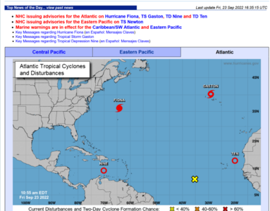
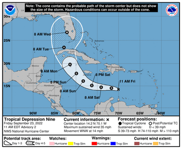
000
WTNT44 KNHC 231454
TCDAT4
Tropical Depression Nine Discussion Number 2
NWS National Hurricane Center Miami FL AL092022
1100 AM EDT Fri Sep 23 2022
The depression remains highly sheared this morning. Visible
satellite imagery and data from an Air Force Reserve Hurricane
Hunter aircraft indicate the center of the system is still exposed
to the east of the associated deep convection. The center also
appears a bit elongated, with a couple of low-level swirls evident
in satellite imagery that appear to be rotating around a mean
center. The aircraft winds and a blend of the latest satellite
estimates support an initial intensity of 30 kt for this advisory.
The long-term motion of the depression is still west-northwestward
at 12 kt. The cyclone is expected to move more westward over the
next 24-36 h as a narrow low- to mid-level ridge builds to the north
of the system. Then, an amplifying deep-layer trough over the
eastern U.S. is forecast to weaken the ridge beginning on Sunday,
which should cause the cyclone to turn northwestward and northward
as it approaches western Cuba early next week. There is increased
spread in the guidance for this portion of the track forecast, with
day 5 positions that span from the eastern Gulf to east of the
Florida peninsula. The latest NHC track forecast lies near the
center of the guidance envelope and closely follows the IVCN and
HCCA aids. This prediction is very similar to the previous one,
with only slight westward adjustments at days 3-5 to reflect the
latest model consensus trends.
The moderate to strong deep-layer northeasterly shear over the
cyclone is expected to persist through tonight, so only slight
strengthening is forecast through early Saturday. But once the shear
decreases to less than 10 kt this weekend, more significant
intensification is forecast as the cyclone moves over SSTs in excess
of 30 deg C. The latest NHC intensity forecast has been increased
from the previous one and explicitly calls for rapid intensification
as the cyclone crosses the northwestern Caribbean Sea. The system
is forecast to approach the Cayman Islands and Cuba as a
strengthening hurricane, with additional intensification likely once
it emerges over the warm waters of the southeastern Gulf of Mexico.
In fact, this forecast calls for the system to approach the Florida
peninsula as a major hurricane by day 5, which is supported by the
latest IVCN and HCCA aids.
Key Messages:
1. The depression is expected to produce heavy rainfall and
instances of flash flooding and possible mudslides in areas of
higher terrain in Aruba, Bonaire, and Curacao. Heavy rains are also
likely to spread into Jamaica, the Cayman Islands, and Cuba in the
coming days.
2. The depression is expected to approach Jamaica as a tropical
storm on Sunday and the Cayman islands as a hurricane on Monday.
Watches for these locations may be required later today or on
Saturday.
3. Early next week the system is forecast to move near or over
western Cuba as a strengthening hurricane and then approach the
Florida peninsula at or near major hurricane strength, with the
potential for significant impacts from storm surge, hurricane-force
winds, and heavy rainfall. While it is too soon to determine the
exact magnitude and location of these impacts, residents in Cuba,
the Florida Keys, and the Florida peninsula should ensure they have
their hurricane plan in place and closely monitor forecast updates
through the weekend.
FORECAST POSITIONS AND MAX WINDS
INIT 23/1500Z 14.2N 70.1W 30 KT 35 MPH
12H 24/0000Z 14.5N 71.7W 35 KT 40 MPH
24H 24/1200Z 14.7N 74.1W 35 KT 40 MPH
36H 25/0000Z 15.1N 76.3W 40 KT 45 MPH
48H 25/1200Z 16.1N 78.3W 45 KT 50 MPH
60H 26/0000Z 17.8N 79.9W 60 KT 70 MPH
72H 26/1200Z 19.8N 81.4W 75 KT 85 MPH
96H 27/1200Z 23.5N 82.8W 90 KT 105 MPH
120H 28/1200Z 26.7N 82.1W 100 KT 115 MPH<----
$$
Forecaster Reinhart

384
WTNT42 KNHC 231449
TCDAT2
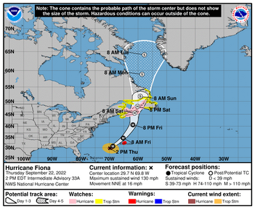
Hurricane Fiona Discussion Number 37
NWS National Hurricane Center Miami FL AL072022
Issued by the NWS Weather Prediction Center College Park MD
1100 AM AST Fri Sep 23 2022
Fiona is pulling away from Bermuda and racing toward Atlantic
Canada. Although the core of Fiona missed Bermuda, the Bermuda
Weather Service reported that there were wind gusts up to 100 kt on
the island early this morning. The Air Force Hurricane Hunters have
been investigating the major hurricane and have found that it
remains powerful and very large. The maximum flight-level wind at
700 mb was 144 kt in the southeast quadrant and the peak SFMR wind
was 109 kt. Based on these data, the initial intensity is nudged up
to 115 kt, which makes Fiona a very dangerous category 4 hurricane
on the Saffir-Simpson Hurricane Wind Scale. Satellite images show
that Fiona still has a relatively well-defined eye and deep
convection over the eastern portion of the circulation, but dry air
and westerly vertical wind shear are beginning to affect the system.
Satellite and aircraft fixes indicate that Fiona is moving very
quickly to the northeast at about 30 kt. The hurricane is expected
to turn slightly to the left and slow down as it interacts and
merges with a nearby mid- to upper-level trough. The center of
Fiona is expected to make landfall in Atlantic Canada late tonight
or early Saturday, but wind, rain, and surge impacts will begin
well before that time given the large size of the hurricane. The
models suggest that Fiona will slow down significantly, but
continue a generally northward motion through the weekend and into
early next week. The NHC track forecast lies close to the middle of
the guidance envelope.
Although Fiona is expected to begin weakening soon given the
increasing shear and dry air entrainment, there is high confidence
that Fiona will be a powerful cyclone when it moves across Atlantic
Canada. The system is forecast to complete extratropical
transition when it merges with the trough just before or around the
time it makes landfall. The NHC intensity forecast lies near the
high end of the guidance in the short term, but falls in line with
the IVCN and HCCA models after that.
Key Messages:
1. Fiona is expected to affect portions of Atlantic Canada as a
powerful hurricane-force cyclone tonight and Saturday, and
significant impacts from high winds, storm surge, and heavy rainfall
are expected. Hurricane and Tropical Storm Warnings are in effect
for much of Atlantic Canada.
2. Tropical storm conditions will likely continue for a few
more hours in Bermuda.
3. Large swells generated by Fiona are expected to cause
life-threatening surf and rip current conditions along much of the
east coast of the United States, the Bahamas, Bermuda, and Atlantic
Canada during the next couple of days.
FORECAST POSITIONS AND MAX WINDS
INIT 23/1500Z 35.9N 64.2W 115 KT 130 MPH
12H 24/0000Z 40.8N 61.4W 105 KT 120 MPH
24H 24/1200Z 45.5N 60.6W 85 KT 100 MPH...POST-TROP/EXTRATROP
36H 25/0000Z 48.4N 59.4W 65 KT 75 MPH...POST-TROP/EXTRATROP
48H 25/1200Z 51.5N 57.9W 50 KT 60 MPH...POST-TROP/EXTRATROP
60H 26/0000Z 55.2N 57.1W 45 KT 50 MPH...POST-TROP/EXTRATROP
72H 26/1200Z 58.3N 56.9W 40 KT 45 MPH...POST-TROP/EXTRATROP
96H 27/1200Z 61.6N 55.7W 40 KT 45 MPH...POST-TROP/EXTRATROP
120H 28/1200Z...DISSIPATED
$$
Forecaster Cangialosi/Snell
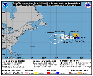
936
WTNT43 KNHC 231457
TCDAT3
Tropical Storm Gaston Discussion Number 13
NWS National Hurricane Center Miami FL AL082022
300 PM GMT Fri Sep 23 2022
Gaston is improving in satellite presentation this morning.
Convection is re-forming and wrapping around the northern and
western sides of the circulation. A recent scatterometer pass
showed that Gaston was slightly stronger than the previous advisory
and the initial intensity has been increased to 55 kt. The
tropical-storm-force wind field was also expanded, especially in the
northwestern quadrant based on these data.
The cyclone has managed to retain its tropical characteristics for
now. Global model guidance suggests moderate to strong vertical
wind shear should gradually strip away convection from the core over
the next day or so. In spite of the relatively hostile conditions,
Gaston has managed to maintain its strength, therefore only gradual
weakening is forecast until the storm merges with a shortwave trough
in about 36 hours and becomes a post-tropical cyclone. The official
intensity forecast has been shifted slightly higher than the
previous advisory due to the initial intensity and is slightly
stronger than the consensus model aids.
The storm is moving east-southeastward at an estimated 120/6 kt. A
sharp turn to the south is expected shortly while Gaston traverses
the periphery of a mid-level ridge building to the north.
Afterward, the cyclone should generally move toward the
west-southwest and west, completing an anticyclone turn, through the
end of the period. The NHC forecast has been nudged slightly
northward once again from the previous forecast and lies between the
HCCA and TVCN multi-model consensus aids.
Key Messages:
1. Tropical storm conditions are occurring over portions of the
western Azores, and are spreading to the central Azores.
2. Gaston is expected to produce heavy rainfall over the western
and central Azores today through Saturday. This rainfall may
result in landslides and areas of flooding.
FORECAST POSITIONS AND MAX WINDS
INIT 23/1500Z 40.2N 29.1W 55 KT 65 MPH
12H 24/0000Z 39.4N 29.0W 55 KT 65 MPH
24H 24/1200Z 38.7N 30.2W 50 KT 60 MPH
36H 25/0000Z 38.7N 32.3W 50 KT 60 MPH...POST-TROPICAL
48H 25/1200Z 38.9N 34.8W 50 KT 60 MPH...POST-TROPICAL
60H 26/0000Z 39.0N 36.7W 45 KT 50 MPH...POST-TROPICAL
72H 26/1200Z 39.0N 38.6W 40 KT 45 MPH...POST-TROPICAL
96H 27/1200Z 38.9N 42.0W 35 KT 40 MPH...POST-TROPICAL
120H 28/1200Z 37.7N 46.2W 30 KT 35 MPH...POST-TROPICAL
$$
Forecaster Bucci
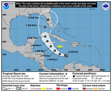
000
WTNT44 KNHC 240853
TCDAT4
Tropical Storm Ian Discussion Number 5
NWS National Hurricane Center Miami FL AL092022
500 AM EDT Sat Sep 24 2022
Ian is still being affected by some north-northeasterly, however
short-wave infrared imagery suggests that the center is located
beneath the eastern edge of the colder convective cloud tops.
Deep convection over the western portion of the circulation has
increased overnight but there is still little banding evident in
conventional satellite imagery. Subjective Dvorak satellite
classifications from TAFB and SAB, and objective estimates from
UW-CIMSS have changed little this cycle, but given that the center
is more involved with the deep convection, the initial intensity
has been increased to 40 kt, which is between the objective
estimates and a TAFB Dvorak T-number of 3.0 or 45 kt. A NOAA
Hurricane Hunter aircraft is scheduled to investigate Ian this
morning, and should provide additional data on Ian's structure
and intensity.
Recent satellite fixes indicate that Ian has turned westward
(270/12 kt) overnight to the south of a narrow ridge centered
near Hispaniola. By early Sunday, Ian is expected to reach the
western portion of the ridge, and the storm should turn
west-northwestward, and then northwestward over the northwestern
Caribbean in 36 to 48 hours. After that time, Ian is forecast to
turn north-northwestward and northward around the western portion
of the ridge. This will bring Ian near or over Western Cuba and
into the southeastern Gulf of Mexico. Late in the period, the
guidance indicates the storm will begin to recurve toward Florida.
As mentioned before, the track models are in general agreement with
this scenario, however there is a large amount of cross-track
spread at 72 hours and beyond. In fact, the east-west spread in
the guidance at 96 hours is about 180 n mi, with the CTCI and ECMWF
along the eastern side of the envelope, and the GFS, HWRF, and GFS
ensemble mean along the western side. The overall guidance
envelope has shifted slightly westward this cycle, and the NHC
track has been nudged in that direction and lies just east of the
various consensus aids. Given the spread in the guidance, and
the still shifting dynamical models, additional adjustments to the
track forecast may be needed in subsequent advisories. Users are
reminded that the long-term average NHC 4- and 5-day track errors
are around 150 and 200 n mi, respectively.
The shear that has been plaguing Ian is forecast to continue to
decrease over the next day or two while the cyclone moves over the
warm waters of the central and northwestern Caribbean Sea. This
should allow for strengthening, with steady to rapid
intensification (RI) quite possible once an inner core becomes
established. Although the updated NHC forecast is just shy of
forecasting RI (30 kt or greater increase over 24 h) during any 24-h
period over the next few days, it calls a 45-kt increase in wind
speed between 24 and 72 hours, and Ian is likely to be near major
hurricane intensity when it approaches western Cuba. Since Ian is
not expected to remain over Cuba long, little weakening is expected
due to that land interaction, and the forecast again shows Ian as a
major hurricane over the eastern Gulf when it is approaching the
west coast of Florida.
Key Messages:
1. Ian is expected to produce heavy rainfall and instances of
flash flooding and possible mudslides in areas of higher terrain,
particularly over Jamaica and Cuba.
2. Hurricane conditions are possible in the Cayman Islands by
early Monday, with tropical storm conditions possible by late
Sunday. Tropical storm conditions are possible in Jamaica on
Sunday.
3. Early next week, Ian is forecast to move near or over western
Cuba as a strengthening hurricane and then approach the Florida
peninsula at or near major hurricane strength, with the potential
for significant impacts from storm surge, hurricane-force winds,
and heavy rainfall. While it is too soon to determine the
exact magnitude and location of these impacts, residents in Cuba,
the Florida Keys, and the Florida peninsula should ensure they have
their hurricane plan in place and closely monitor forecast updates
through the weekend.
FORECAST POSITIONS AND MAX WINDS
INIT 24/0900Z 14.7N 73.5W 40 KT 45 MPH
12H 24/1800Z 14.6N 75.2W 45 KT 50 MPH
24H 25/0600Z 15.2N 77.4W 50 KT 60 MPH
36H 25/1800Z 16.5N 79.4W 60 KT 70 MPH
48H 26/0600Z 18.2N 81.0W 70 KT 80 MPH
60H 26/1800Z 20.2N 82.4W 85 KT 100 MPH
72H 27/0600Z 22.0N 83.3W 95 KT 110 MPH
96H 28/0600Z 25.5N 83.3W 100 KT 115 MPH
120H 29/0600Z 28.2N 82.1W 85 KT 100 MPH...INLAND
Probably going to check the gas tank on the grill today and see about getting a new one if is low. Might also fill the car up
with gas and put in a grocery order for some of our standard "hurricane" prep-type food. We're on one side of the state and
my parents are on the other so its bound to affect at least one of us. I worry about my parents because they are in their
80s and don't have any help where they are.