shape
carat
color
clarity

Houston/Gulf/FL Peninsula (Laura and Marco)

Arcadian

Ideal_Rock
Premium
Joined
Sep 17, 2008
Messages
9,438
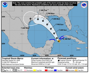
Marco has not yet been named but they're saying it will be soon.

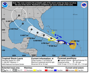
Time frames are early next week. If Laura pulls an Irma , the entire Florida Peninsula will feel it, most of us lost power as it we were on the east side of it. East side is the worst side for hurricanes. I'm hoping for no further development.

TS14 shows room for plenty of development and could smack Houston pretty good. If they hit close to the same time, that could be a big ol mess...again, lets hope 2020 dosen't continue to be its fabulous self and come to that.


two_atl_2d0.png
 
You've become our resident virtual storm chaser @Arcadian !

I'm following! 2020 sure has been a s**t show hasnt it?
 
You've become our resident virtual storm chaser @Arcadian !

I'm following! 2020 sure has been a s**t show hasnt it?

LOL They scare me to death! Last night me and the dog hung out on her bed wrapped in a blanket because of a few storms that hit us pretty hard. Reporting it helps me to keep it in perspective and not get too messed up in my head.

The bad is the atlantic season is just starting to heat up. I don't know how much more excitement I can take...lol


The good is that I'm set, no need to go out and get anything.
 
I just saw this this morning...thinking of everyone in the path of these storms, please take care. <3
Thanks for keeping us updated @Arcadian.
 
They are at current doing really doofy things. The models have been weird all year, so who knows. I think at current FL is not in the cone at all, so if there's a continuance to drift NW not sure whats going to happen!! Basically we should all watch and be ready for anything squirrley.
 
E9DB2B3D-16CE-46AF-A6F0-D04856DD1770.jpeg

I’m guessing this can apply to Florida also.

So far, yes and no. There's already warnings for parts of SoFL as we're watching Laura very closely.

Actually did hear that panhandle has some warnings, especially areas where Michael decimated (Paradise, FL)
 
Last edited:
laura144355_5day_cone_no_line_and_wind.png
marco145755_5day_cone_no_line_and_wind.png


So this is what we're looking at now. I woke up and heard Marco is scheduled to be a hurricane today, and its moving east. Louisiana looks like its going to get some of both. :shock:
 
Prayers to you @Arcadian and all in the path of the storms. Take care

We're doing wait and see on Laura so we (SEFL) may not have much to worry about as its still quite a messy storm and, looks like it could continue to drift south. If the storm stacks (its very messy right now) and begins to strenthen, then it could go east and then it could bring some weather our way. TropicalTidbits.com is a great site. Learned a lot about these storms here (its still way over my head though...lol) Marco on the other hand will really be a threat as I'm hearing it looks on track to be a hurricane sometime today.
 
laura205347_5day_cone_no_line_and_wind.png
marco205851_5day_cone_no_line_and_wind.png
The 5 oclock track. :shock:

This is exhausting to keep up with. @whitewave basically you guys may well have back to back storms in your area. Really, no one in the gulf is out on this one as there's plenty of time for shifts.
 
HI:

Hold fast! Keep safe peoples!!!!!!

kind regards--Sharon
 
Hope everyone in or near the cone is ramping up. What a pain trying to stock up while there's a pandemic!
(I'm nowhere near the cone but I certainly can empathize with everyone who is!)
 
Now they're saying that Laura's track is going south instead of north, which could mean a stronger Laura. Currently Puerto Rico is taking the beating. I won't post anything until after 8am to see what the newest forecasts are.

Though SoFL is out of the cone, parts are on track to get some possible flooding, and that holds true for The Keys for now. Where I am, we'll get some funky rain bands and possible water spouts/tornadoes/localized flooding and it will be yucky but not terrible. Eastern jogs of course make it worse. My biggest worry will be tornadoes.
 
marco145755_5day_cone_no_line_and_wind.pnglaura144355_5day_cone_no_line_and_wind.png

The 11am tracks. Laura is drifting closer to texas state line. If there's an eye replacement going on to the south then texas could get a lot more of Laura.
 
Ok Well....
Laura did in fact shift southwest which will give her more time to strengthen over water... this also means a possible cat 2 or better at landfall. I think thats now the updated forecast.

And Marco is now a hurricane but will weaken because of some midlevel shearing going on right now, meaning, might only be a TS or a low level H at landfall.

I heard that everyone from Corpus Christi to Floribama needs to be on guard and pay attention to Laura as there's lot of uncertainly about the landing. High is building back over the peninsula so it won't go that way.

marco215149_5day_cone_no_line_and_wind.png

laura205733_5day_cone_no_line_and_wind.png
 
We have had no effects at all today from Marco. I’m not complaining.

We got them...lol the sheer blew the top off and shoved it Florida's way.
 
Marco may die prior to landfall is the current consensus as the convection has been pretty much been blown east. Mostly the panhandle got it, though we did see some quite sudden and intense rains in SoFl yesterday/last night.


will see what the 11am advisory brings.
 
Yes, there is nothing going on here, except a light breeze and less humidity and lower temps. It’s quite nice outside today.
 
We're actually very windy currently roughly 23mph from Laura with higher gusts. South/Keys is getting way more of it right now.

marco092405_5day_cone_no_line_and_wind.png
laura154444_5day_cone_no_line_and_wind.png

Both of these have just acted so weird. And even know there's not a real consensus on Laura except that they are believing that it will have very little shear in the gulf. the high will be over FL if it dosen't speed up and thus, will grow. How that storm survived over all those mountains is kinda scary, just says it was organized more than meteorologists thought!
 

Attachments

  • marco145755_5day_cone_no_line_and_wind.png
    marco145755_5day_cone_no_line_and_wind.png
    84 KB · Views: 21
  • laura144355_5day_cone_no_line_and_wind.png
    laura144355_5day_cone_no_line_and_wind.png
    90.4 KB · Views: 21
Marco is a nothing burger

@Bayek is right, you're a doll @whitewave

We're getting laura winds, which even as far as we are away, they're gusting to 35mph right now and its even more south of me.

After she leaves cuba she's got 2 days in a bathtub with no fans to blow the top off. People along the coast western side of the gulf should consider their options of possibly leaving if asked. The intensity models I looked at are pretty bad. She's not small, and if we can feel her winds where I am in PBC....that should say enough.
 
Still nothing going on here. It’s a little cloudy now but that is all.

Arcadian, thank you too!
 
Marco blipped and made landfall. @whitewave did y'all even notice?
 
laura093605_5day_cone_no_line_and_wind.png

shit there could be a shift west. Please remember that the cone only says where the eye might be. It doesn't say anything about the rest of the storm (which is big!!) Houston folks this means you so please watch and pay attention!
 
GET 3 FREE HCA RESULTS JOIN THE FORUM. ASK FOR HELP
Top