shape
carat
color
clarity

Storm Nicholas (Texas Coast, this is y'alls)

Arcadian

Ideal_Rock
Premium
Joined
Sep 17, 2008
Messages
9,445
two_atl_2d0.png
150131_5day_cone_no_line_and_wind.png
 
Parts of Louisiana will get this storm as well. Its peak season so there's lots of movement in the basin.

They're expected to stay tropical storms...lets hope for that!

Lot of rain expected though and for those areas that got hit by Ida, this isn't going to do a lot of help.
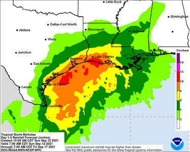
150131WPCQPF_sm.gif

Texas, Monday/Tuesday Time frame. Louisiana Tuesday/Wednesday Time frame.

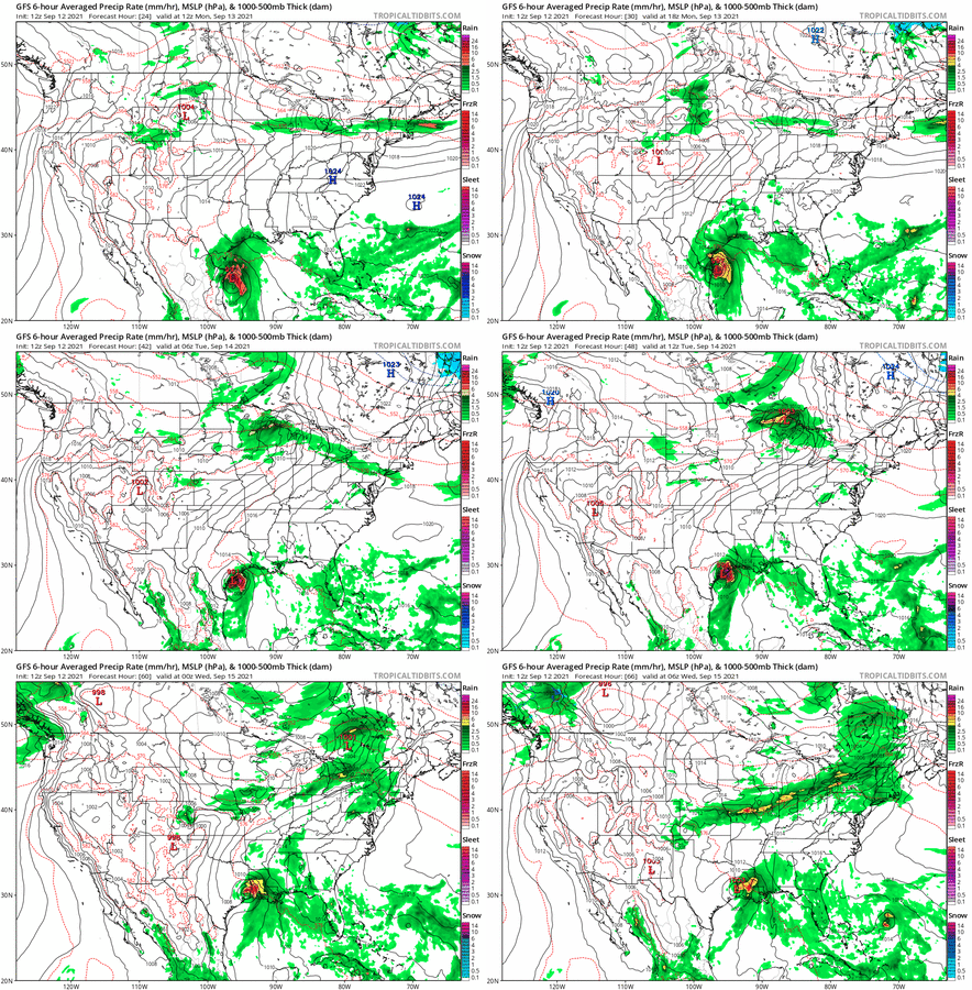
Whats expected (only one model run but they're all in good agreement)
gfs_mslp_pcpn_frzn_us_fh24-66.gif
 
A couple of model runs are showing a pretty solid Cat 1. It COULD go higher Warm water where this is still forming.


000
WTNT44 KNHC 122101
TCDAT4

Tropical Storm Nicholas Discussion Number 2
NWS National Hurricane Center Miami FL AL142021
400 PM CDT Sun Sep 12 2021

Visible satellite imagery, scatterometer wind data, and earlier
reconnaissance aircraft observations indicate that the circulation
of Nicholas is elongated from northwest to southeast. In fact,
visible satellite imagery and the aircraft data has shown that
there have been several low-level swirls rotating about a mean
center. This is not surprising since the tropical cyclone is
still in its formative stage. The Air Force plane did not find
winds any stronger than they did this morning and the ASCAT data
revealed peaks winds of around 30 kt. Given the typical
undersampling of the scatterometer instrument, the earlier aircraft
data, and peak one-minute wind observations of 31 kt from NOAA buoy
42055 earlier today, the intensity remains 35 kt for this advisory.

Nicholas will be moving over the warm waters of the western Gulf of
Mexico during the next day or so, and this combined with a moist,
unstable atmosphere favors strengthening. The primarily inhibiting
factor appears to be moderate south-southwesterly vertical wind
shear caused by an upper-level trough over northern Mexico. The
trough is forecast to move westward and weaken during the next day
or so, which could allow for a more favorable upper-level wind
pattern later tonight and Monday. The NHC intensity forecast again
calls for strengthening while the system moves toward the northwest
Gulf coast, but the main uncertainty regarding the intensity
forecast is how much time the cyclone will spend over the Gulf
waters. The GFS and HWRF models, which depict a track farther
east, show significantly more strengthening than the UKMET and ECMWF
models which show a weaker tropical cyclone moving inland over
northeastern Mexico or southern Texas much sooner. The NHC intensity
forecast is similar to the previous advisory, but indicates a faster
rate of strengthening during the next 12-24 hours. Although not
explicitly shown in the intensity forecast, Nicholas could approach
hurricane strength when it nears the northwest Gulf coast,
especially if it moves to the right of the NHC forecast track and
spends more time over water. Due to this uncertainty a Hurricane
Watch has been issued a for a portion of the Texas coast. The NHC
forecast is in best agreement with the SHIPS and HFIP corrected
consensus model, but is not as high as the latest HWRF.

The center of Nicholas appears to have re-formed farther north since
this morning and the initial motion estimate is again a somewhat
uncertain 340/12 kt. The track forecast reasoning has not changed
from this morning. Nicholas should move north-northwestward to
northward during the next day or so around the western portion of a
mid-level ridge that is located near the southeast U.S. coast. The
latest runs of the various dynamical models have shown typical
variability, but the overall guidance envelope has not changed too
much through the first 36 hours. The GFS has been the most
consistent model and its 12Z run was fairly close to the previous
NHC track forecast. Therefore, the NHC track leans along the right
side of the guidance envelope between the HWRF and GFS, which
are a little to the right of the consensus aids. Due to the acute
angle of approach of Nicholas to the coast, users are reminded to
not focus on the exact forecast track as small changes in the
heading of the cyclone could result in differences in both the
location and timing of landfall. Regardless of where Nicholas makes
landfall, storm surge, wind, and rainfall impacts are likely over a
large portion of northeastern Mexico and Texas coastal areas.
After landfall, a slower north-northeastward motion is forecast, and
by 72 hours the cyclone is forecast to be located between a couple
of mid-level ridges, which will likely result in weaker
steering currents and an even slower northeastward motion. By day
5, the global model guidance suggest that the low-level circulation
will become an open trough so dissipation is indicated at that time.

Key Messages:

1. Periods of heavy rainfall are expected to impact portions of the
Texas and Louisiana coasts today through the middle of the week.
Significant rainfall amounts are possible, potentially resulting in
areas of considerable flash and urban flooding, especially in highly
urbanized metropolitan areas. Isolated minor to moderate river
flooding is also expected.

2. There is the danger of life-threatening storm surge inundation
along the coast of Texas from Port Aransas to San Luis Pass.
Residents in these areas should follow any advice given by
local officials.

3. Nicholas is forecast to approach the middle Texas coast as a
strong tropical storm late Monday and early Tuesday, and could be
near hurricane intensity if it moves to the right of the forecast
track and remains over water longer. Tropical storm conditions are
expected along portions of the middle Texas coast beginning Monday
afternoon, with hurricane conditions possible from Port Aransas to
Sargent late Monday and Monday night.

4. Tropical storm conditions are expected along portions of the
northeastern coast of Mexico and the coast of south Texas beginning
Monday morning.

FORECAST POSITIONS AND MAX WINDS

INIT 12/2100Z 22.8N 95.5W 35 KT 40 MPH
12H 13/0600Z 24.4N 96.3W 45 KT 50 MPH
24H 13/1800Z 26.7N 96.9W 55 KT 65 MPH
36H 14/0600Z 28.7N 96.8W 55 KT 65 MPH...INLAND
48H 14/1800Z 30.4N 96.3W 35 KT 40 MPH...INLAND
60H 15/0600Z 31.2N 95.8W 30 KT 35 MPH...INLAND
72H 15/1800Z 31.7N 95.2W 25 KT 30 MPH...INLAND
96H 16/1800Z 31.9N 94.7W 20 KT 25 MPH...POST-TROP/REMNT LOW
120H 17/1800Z...DISSIPATED

$$
Forecaster Brown
 
Definitely peak season......


two_atl_5d0.png
 
So I finally started really reading some of the key messages here. People from Corpus Christi to St Charles, LA take note. And yes even greater NOLA needs to pay attention because these ran fall totals appear to be going up because of high tide.

Based on the key messaging, they're expecting an impactful storm and people can lose their lives if they don't heed warnings. I sincerely hope someone in somebody's new room is putting these messages out.

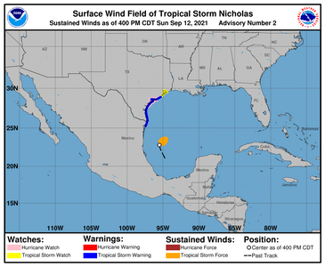
Along the east coast of Texas, in some spots there's now Hurricane watch up.

1213616_current_wind_sm.png

HAZARDS AFFECTING LAND
----------------------
Key messages for Nicholas can be found in the Tropical Cyclone
Discussion under AWIPS header MIATCDAT4, WMO header WTNT44 KNHC
and on the web at hurricanes.gov/graphics_at4.shtml?key_messages

RAINFALL: Nicholas is expected to produce storm total rainfall of
8 to 16 inches, with isolated maximum amounts of 20 inches, across
portions of the middle and upper Texas coastal areas today through
the middle of the week. Across the rest of coastal Texas into
southwest Louisiana rainfall of 5 to 10 inches is expected. This
rainfall may produce areas of considerable flash and urban flooding,
especially in highly urbanized metropolitan areas. Additionally,
there is the potential for isolated minor to moderate river
flooding.

Over the northeastern portions of the Mexican state of Tamaulipas
rainfall amounts of 2 to 5 inches can be expected today into Monday.

STORM SURGE: The combination of a dangerous storm surge and the tide
will cause normally dry areas near the coast to be flooded by rising
waters moving inland from the shoreline. The water could reach the
following heights above ground somewhere in the indicated areas if
the peak surge occurs at the time of high tide...

Port O'Connor to San Luis Pass TX including Matagorda Bay...3-5 ft
Mouth of the Rio Grande to Port O'Connor, TX...2-4 ft
San Luis Pass to High Island, TX including Galveston Bay...2-4ft
Baffin Bay, Corpus Christi Bay, Aransas Bay and San Antonio
Bay...2-4 ft
High Island, TX to Intracoastal City including Sabine Lake and
Calcasieu Lake..1-3 ft


The deepest water will occur along the immediate coast in areas
of onshore flow, where the surge will be accompanied by large and
dangerous waves. Surge-related flooding depends on the relative
timing of the surge and the tidal cycle, and can vary greatly over
short distances. For information specific to your area, please see
products issued by your local National Weather Service forecast
office.

WIND: Tropical storm conditions are expected to first reach the
coast within the warning area in northeastern Mexico and southern
Texas Monday morning, making outside preparations difficult or
dangerous.
These conditions will spread northward within the
warning area through Monday night. Hurricane conditions are
possible in the Hurricane Watch area Monday night. Tropical storm
conditions are possible within the watch area by late Monday night
or early Tuesday.

TORNADOES: A tornado or two will be possible Monday into Monday
night across the middle and lower Texas coast.

SURF: Swells generated by Nicholas will begin affecting
portions of the northwest Gulf coast later tonight and continue
into Tuesday. These swells are likely to cause life-threatening
surf and rip current conditions. Please consult products from your
local weather office.


NEXT ADVISORY
-------------
Next intermediate advisory at 700 PM CDT.
Next complete advisory at 1000 PM CDT.
 
Hurricane hunters are all in this storm and quite interesting what the findings are. too close to land to get anywhere beyond a cat 1 it looks like, but, appears that it might be a slow moving storm...yuck.

recon is currently happening


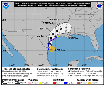
115300_5day_cone_no_line_and_wind.png


000
WTNT44 KNHC 130850
TCDAT4

Tropical Storm Nicholas Discussion Number 5
NWS National Hurricane Center Miami FL AL142021
400 AM CDT Mon Sep 13 2021

Radar data from Brownsville shows that the center of Nicholas is on
the southwestern side of a large area of deep convection over the
western Gulf of Mexico. While southwesterly shear continues to
affect the storm, the radar presentation has recently improved,
with what could be the start of a partial eyewall forming in the
northern quadrant. The initial wind speed remains 50 kt based on
earlier aircraft flight-level winds of 59 kt, believable SFMR
values up to 50 kt, along with radar winds at 5000 ft near 60 kt.

The storm is moving north-northwestward at about 12 kt. Nicholas is
forecast to turn northward soon into a weakness in the subtropical
ridge. The track prediction is only nudged slightly westward from
the previous one through landfall, consistent with recent model
guidance. Thereafter, there isn't good agreement among the models
on how quickly the tropical cyclone will move northeastward out of
Texas. Generally the models are faster this cycle, which seems
believable given the large northward re-formation earlier likely
exposing Nicholas to stronger mid-latitude flow. Thus the new NHC
forecast is trended faster as well, but remains behind the model
consensus. Obviously the forward speed is important to the heavy
rainfall forecast, and this trend will be one to watch.

Nicholas should continue to strengthen up until landfall due
primarily to the very warm Gulf waters and the recent inner-core
improvements. Moderate southwesterly shear and some dry air are the
main inhibiting factors and will hopefully keep the strengthening in
check. However, it is possible that Nicholas could become a
hurricane before landfall, and that's the reason for the hurricane
watch area. Nicholas should weaken after landfall, diminish into a
tropical depression within a couple of days, and degenerate into a
remnant low in about 3 days. No significant changes were made to
the previous NHC wind speed prediction.


Key Messages:

1. Heavy rainfall will impact portions of the Texas and Louisiana
coasts through the middle of the week. Significant rainfall amounts
are possible, potentially resulting in areas of considerable flash
and urban flooding, especially in highly urbanized metropolitan
areas. Isolated minor to moderate river flooding is also expected.

2. There is the danger of life-threatening storm surge inundation
along the coast of Texas from Port Aransas to San Luis Pass.
Residents in these areas should follow any advice given by
local officials.

3. Nicholas is forecast to approach the middle Texas coast as a
strong tropical storm today, and could be near hurricane
intensity at landfall. Tropical storm conditions are expected
along portions of the middle Texas coast beginning by this
afternoon, with hurricane conditions possible from Port Aransas to
Freeport this afternoon and tonight.

4. Tropical storm conditions are expected along portions of the
northeastern coast of Mexico and the coast of south Texas beginning
during the next few hours.


FORECAST POSITIONS AND MAX WINDS

INIT 13/0900Z 25.5N 96.6W 50 KT 60 MPH
12H 13/1800Z 27.3N 96.8W 60 KT 70 MPH
24H 14/0600Z 29.2N 96.5W 45 KT 50 MPH...INLAND
36H 14/1800Z 30.6N 95.8W 35 KT 40 MPH...INLAND
48H 15/0600Z 31.5N 94.5W 30 KT 35 MPH...INLAND
60H 15/1800Z 32.1N 93.0W 25 KT 30 MPH...INLAND
72H 16/0600Z 32.5N 91.5W 20 KT 25 MPH...POST-TROP/REMNT LOW
96H 17/0600Z...DISSIPATED
 
School dismissed early today and no school tomorrow. Everyone is at the HEB getting supplies!
 
Good @oceanblue Glad its being taken seriously. The biggest threat in all of this is the amount of rain coming down. The wind is negligible as it may not actually reach hurricane strength (it could, not out of the cards yet)

Low end storms can cause damage if they're slow moving.
 
I'm hoping our Texas folks are doing well and prepping. I'm hearing some reports of road closers due to water and wind gusts at 64MPH....thats a lot. with the change in track easterly it gives a bit more time over water which is not good.

Storm could strengthen tonight but lets hope not. The speed in which its moving means lots of rain being dumped over the the coast.
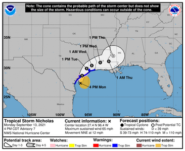
204241_5day_cone_no_line_and_wind.png

096
WTNT44 KNHC 132045 CCA
TCDAT4

Tropical Storm Nicholas Discussion Number 7...Corrected
NWS National Hurricane Center Miami FL AL142021
400 PM CDT Mon Sep 13 2021

Corrected third paragraph typo

Earlier reconnaissance aircraft flight-level wind data, along with
recent Doppler radar velocity data from Brownsville and Corpus
Christi, indicate that the inner-core wind field has still not
consolidated into a single low-level wind center. High-resolution
1-minute GOES-16 visible satellite imagery, radar data, and
reconnaissance wind data all indicate at least three small but very
tight swirls revolving counter-clockwise around a mean center. An
eye feature has tried to form on multiple occasions, only to
dissipate after less than half an hour. An Air Force Reserve
Hurricane Hunter aircraft sampled the most of the northeastern
quadrant of Nicholas' larger circulation this morning and afternoon,
and measured 63-67-kt 850-mb flight-level winds, which roughly
equals 53-54-kt surface winds in that quadrant; the aircraft also
found SFMR surface winds of 50-51 kt in the same area. In addition,
Doppler velocity data from Corpus Christi and Brownsville have been
indicating average velocities of 59-60 kt between 9,000-10,000 ft
near the center, which also equates to about 53-54-kt surface winds.
Based on these wind data, the advisory intensity has been increased
to 55 kt.


The initial motion estimate is 015/10 kt. The new NHC model guidance
has come into better agreement on Nicholas moving toward the north-
northeast until landfall occurs, now that the 12Z ECMWF model
has made a significant eastward shift closer to the previous and
current GFS and HWRF model solutions. After landfall, Nicholas is
expected to move around the northwestern periphery of a deep-layer
subtropical ridge that is oriented east-to-west across the central
and eastern Gulf of Mexico. The latest guidance has continued to
trend more eastward through 24 hours, followed by a more southward
or right-of-track trend thereafter. As a result, the new NHC track
forecast has followed suit, and has also been shifted a little to
the right of the previous advisory track, and lies between the
tightly packed consensus models to the west and the GFS model to the
east.

Doppler velocity data from the Houston WSR-88D radar has shown a
large swath of hurricane-force wind speeds in the northeastern
quadrant of Nicholas' circulation above 12,000 ft during the past
couple of hours, with brief appearances of average velocities of
80-100 kt at high altitudes. Thus, there is an abundance of
large-scale cyclonic vorticity available for another burst of
intense convection to tap into, which could allow Nicholas to
approach hurricane strength by landfall. This would most likely
occur tonight during the convective maximum period near landfall
where increased frictional convergence along the coast could aid in
the development of convection on the west side of the circulation.
After landfall, rapid weakening is expected owing to land
interaction, strong southwesterly vertical wind shear in excess of
30 kt, and entrainment of mid-level dry air from the southern
Plains. As a result of these negative conditions, Nicholas is
forecast to weaken to tropical depression by late Tuesday and
degenerate into a remnant low on Wednesday.

Key Messages:

1. Heavy rainfall will impact portions of southeastern Texas,
Louisiana, and southern Mississippi through the middle of the week.

Significant rainfall amounts are possible, potentially resulting in
areas of life-threatening flash and urban flooding, especially in
highly urbanized metropolitan areas. Minor to isolated moderate
river flooding is also expected, along with isolated major river
flooding across smaller river basins and urban areas.

2. There is the danger of life-threatening storm surge inundation
along the coast of Texas from Port Aransas to Sabine Pass.
Residents in these areas should follow any advice given by
local officials.

3. Nicholas is forecast to approach the middle Texas coast as a
strong tropical storm this evening, and could be near hurricane
intensity at landfall. Tropical storm conditions are expected
along portions of the middle and upper Texas coasts this
evening and tonight, with hurricane conditions possible from Port
Aransas to San Luis Pass
.

FORECAST POSITIONS AND MAX WINDS

INIT 13/2100Z 27.4N 96.4W 55 KT 65 MPH
12H 14/0600Z 28.7N 96.1W 60 KT 70 MPH...ON THE COAST
24H 14/1800Z 29.9N 95.3W 40 KT 45 MPH...INLAND
36H 15/0600Z 30.4N 94.4W 30 KT 35 MPH...INLAND
48H 15/1800Z 30.9N 92.9W 25 KT 30 MPH...INLAND
60H 16/0600Z 31.1N 91.4W 20 KT 25 MPH...INLAND
72H 16/1800Z 32.0N 90.6W 20 KT 25 MPH...POST-TROP/REMNT LOW
96H 17/1800Z...DISSIPATED

$$
Forecaster Stewart
 
School dismissed early today and no school tomorrow. Everyone is at the HEB getting supplies!

Thanks @Arcadian for keeping us updated. You are an awesome weather lady!

I couldn't even find a parking place at HEB! I ended up at Kroger just to get a few staples. Hopefully this won't be that bad.
 
Ugh, just got notified our flight home tomorrow from Houston has been cancelled. Desperately trying to find another flight via somewhere out of the way of the storm, so we can get home.
 
@Austina, Could you get to Dallas and fly out of there?
 
We’re trying @Calliecake, ATM we’re rebooked on Wednesday’s flight. We’re going to see what the situation is in the morning, and then try to see if there’s availability for Dallas, but when we originally booked we couldn’t get a return journey from there. Keep your fingers crossed, we really need to get home to finalise the sale of our house and get it packed up.
 
@Austina, We are supposed to have good weather in Chicago this week. If you can’t get a flight to London from Texas please see if you can get a flight to Chicago with a connecting flight to London leaving Chicago. It’s always good to have options.
 
Lot of outages this morning unfortunately.


Apparently the storm strengthened overnight to a Cat 1 right before landfall.

There's going to be an 8am CDT advisory that comes out, which unfortunately will be for Louisiana.

@Gussie and @Austina Glad that you guys are doing well!
 
We’ve managed to rebook for tomorrow, so will see what the situation is then.

If we can’t fly tomorrow from Houston, we’ll try for Chicago/London @Calliecake, but there was no way we were going to sit in Economy on an overnight flight tonight :lol:
 
We’ve managed to rebook for tomorrow, so will see what the situation is then.

If we can’t fly tomorrow from Houston, we’ll try for Chicago/London @Calliecake, but there was no way we were going to sit in Economy on an overnight flight tonight :lol:

I hope your flight works out tomorrow @Austina.
 
Good luck @Austina. I hope everything works out well and you have a safe flight home.
 
@Austina I hope you made it to your destination. Nicolas is a depression but still dumping rain.
 
Thanks @Arcadian, we managed to get the flight yesterday, and arrived home this morning. IAH looked quite soggy, but I couldn’t see any downed trees or damage on our descent in from Austin.
 
GET 3 FREE HCA RESULTS JOIN THE FORUM. ASK FOR HELP
Top