shape
carat
color
clarity

Northeast US - Henri might be the one to watch!

AGBF

Super_Ideal_Rock
Premium
Joined
Jan 26, 2003
Messages
22,146
Hi @Slick1 not sure what the news up there is concentrating on but they may be thinking oh, just a tropical storm. But they can do serious damage especially if the ground has been previously saturated. all that water has to go somewhere!

The colder waters up there is what some are counting on to minimize this storm.

Hang in there friend.

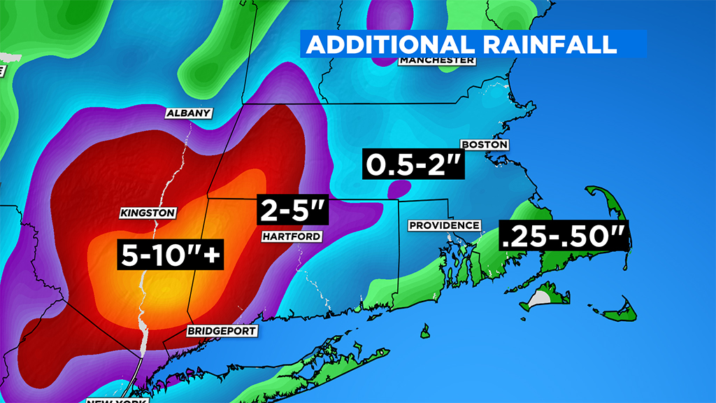
I am glad you mentioned this, @Arcadian. Even if we "only" get a tropical storm in my area of coastal Connecticut, there may be flooding as well as a storm surge. (I have a good friend with a house on the water.) We have had a huge amount of rain this season. The ground has to be saturated. My basement keeps getting water in it because it comes in the side of the house. The contractor who promised to do excavation to stop that ever did it.

"Check: Tropical Storm Henri Path


In general, the strongest winds are found to the east of the center track and the heaviest rainfall to the west of the center track.


Henri is not going to be your typical New England hurricane/tropical storm though (if there is such a thing). Most times hurricanes fly through our area with rapid speed, all the “big ones” did so (Hurricane of ’38, Carol, Diane, Gloria, Bob etc.). Henri is going to slow down upon arrival (the opposite of what is typical), and likely spin itself out over the course of a few days in our region. While this may mean slightly less wind at the peak of the storm (typically you would add the storms max winds with the forward speed to get the strongest gusts), it will almost certainly mean a higher risk of inland flooding.


Given the near record summer of rain we have already had, New England is in no condition to absorb days of rain from a tropical system."


Arcadian

Ideal_Rock
Premium
Joined
Sep 17, 2008
Messages
9,091
Two days ago I got a loud alert at 2am saying a tornado was in the area, go to the basement, etc. I opened the window and there was no wind at all. Nada, zip, zilch. We live on the east coast, not exactly known for tornados. Then the alert came again and I got no sleep from that point on. Further research showed that the tornado was nowhere near me, I'd have had to drive nearly an hour to get there. Thank you national weather service. Not.

I've been through some pretty gnarly storms, from EF3 tornadoes to cat 4 hurricanes, not to mention blizzards, fires, and even earthquakes. Wish I could say I've never had to deal with volcanos but I have (not living near one, but dealt with it on vacation).

I'd rather have a nothingburger and be prepared, than to have all kinds of hell wrecking my house and my nerves.

I get what you're saying, and the reality is, some systems are not as good as they should be and meteorology is ever evolving. its one of those professions where you can be totally wrong and still keep your job!! No science is ever truly exact, and, at least you hope that science learns from its mistakes (it has but still has a ways to go where weather is concerned).

Even with Henri, there's ambiguity (all storms have them) but a lot of discussion happened, a lot of physical reconnaissance had to happen because the model agreement just wasn't there. Instead of saying nothing and putting people in danger at the last minute (which has happened in the past), the warnings go out for people to watch and prepare. Better to do that early than panic last minute.

In this case, the storm is more than just some high wind. Its big enough that it will bring heavy rain to an area thats already heavily saturated. Along with the storm surge along the coast, thats much more danger in that than the wind.
 

Arcadian

Ideal_Rock
Premium
Joined
Sep 17, 2008
Messages
9,091
New models out at 8pm EDT. As said, don't focus too heavy on the cone as thats only where the eye might be. The damage that can happen is mostly outside that cone.


599
WTNT43 KNHC 202042
TCDAT3

Tropical Storm Henri Discussion Number 20
NWS National Hurricane Center Miami FL AL082021
500 PM EDT Fri Aug 20 2021

Henri appears to be slowly gaining strength. Deep convection has
been increasing during the past few hours and the upper-level
outflow continues to become better established on the east side of
the circulation. However, the low-level center is still located
near the northwestern edge of the deep convection due to ongoing
northerly wind shear. An ASCAT-B pass from a few hours ago showed
peak winds of around 55 kt, with the strongest winds on the
southeast side of the circulation. Based on this data, the initial
intensity is set at 60 kt. An Air Force Reserve Hurricane Hunter
aircraft is scheduled to investigate Henri again this evening and
the data the plane collects will be very helpful in estimating the
storm's strength and structure.

The tropical storm appears to be making the advertised turn to the
right, with the latest initial motion estimated to be 335/6 kt. A
trough over the central Appalachians is expected to cut off tonight,
and the combination of that feature and a building ridge to the
east/northeast of Henri should cause the storm to accelerate to the
north on Saturday. The latest model runs have generally trended to
the left again and are a bit faster, with most showing landfall in
about 48 hours. Most of the models now show a slight left turn
before landfall as Henri gets caught in the circulation of the
aforementioned trough. The latest GFS and ECMWF ensemble members
continue to span a region from near New York City to Cape Cod for
the landfall point. Based on the latest consensus aids, the
official track forecast has again been nudged to the west of the
previous one and shows landfall occurring on Sunday. After day 3,
Henri is forecast to eject northeastward.

The ongoing northerly shear is expected to decrease tonight, and
the global models show a favorable upper-level wind pattern
developing over the storm through the weekend. These more
conducive atmospheric conditions combined with the warm Gulf
Stream waters should allow Henri to strengthen to a hurricane
tonight or early Saturday, with additional intensification expected
into Saturday night. By early Sunday, however, Henri is forecast to
cross the north wall of the Gulf Stream, and that should end its
opportunity for strengthening. Although steady to rapid weakening is
forecast while Henri moves over cooler waters south of Long
Island and New England, it will likely still be at or very near
hurricane intensity when it reaches the coast. Post-tropical
transition is forecast to occur by day 3 and the system should
dissipate in 4 or 5 days.

Users are reminded to not focus on the exact forecast of the
center of Henri since impacts will extend far from the center.


If you're so inclined, use the windy app which is very user friendly.


Tropical Tidbits - Dr Cowan is a specialist with these types of storms. This is a pretty good video for those who might be interested in hearing more technical explanation to whats happening as well as a plain english breakdown.


Arcadian

Ideal_Rock
Premium
Joined
Sep 17, 2008
Messages
9,091
A Recon is now ongoing. and NHC has said nothing new at the 8pm update. there may be something different at 11PM EST but might not. Tomorrow afternoon is when things start being real time.

If you don't have a small crank weather radio, try looking at home depot/Lowes. they generally have things like that. Also solar powered lights can be your friend if you can get nothing else, but small puck lights has saved my butt more than once.


YadaYadaYada

Super_Ideal_Rock
Premium
Joined
Feb 2, 2016
Messages
11,912
We actually used the outdoor landscaping lights last year when we were out of power for days. They are handy in a pinch!

Husband bought 20lbs of ice tonight for the cooler in case we need it. Tomorrow out to hunt and gather necessities along with the other million people!

CT looks to be taking quite the hit with this one!
 

Asscherhalo_lover

Ideal_Rock
Premium
Joined
Aug 16, 2007
Messages
5,738
A Recon is now ongoing. and NHC has said nothing new at the 8pm update. there may be something different at 11PM EST but might not. Tomorrow afternoon is when things start being real time.

If you don't have a small crank weather radio, try looking at home depot/Lowes. they generally have things like that. Also solar powered lights can be your friend if you can get nothing else, but small puck lights has saved my butt more than once.


I've had one since Sandy!
 

lambskin

Ideal_Rock
Premium
Joined
Aug 22, 2012
Messages
3,054
Any predictions for Boston Monday thru Wednesday? Have to travel there.
 

doberman

Ideal_Rock
Premium
Joined
Mar 2, 2012
Messages
2,417
I've been through some pretty gnarly storms, from EF3 tornadoes to cat 4 hurricanes, not to mention blizzards, fires, and even earthquakes. Wish I could say I've never had to deal with volcanos but I have (not living near one, but dealt with it on vacation).

I'd rather have a nothingburger and be prepared, than to have all kinds of hell wrecking my house and my nerves.

I get what you're saying, and the reality is, some systems are not as good as they should be and meteorology is ever evolving. its one of those professions where you can be totally wrong and still keep your job!! No science is ever truly exact, and, at least you hope that science learns from its mistakes (it has but still has a ways to go where weather is concerned).

Even with Henri, there's ambiguity (all storms have them) but a lot of discussion happened, a lot of physical reconnaissance had to happen because the model agreement just wasn't there. Instead of saying nothing and putting people in danger at the last minute (which has happened in the past), the warnings go out for people to watch and prepare. Better to do that early than panic last minute.

In this case, the storm is more than just some high wind. Its big enough that it will bring heavy rain to an area thats already heavily saturated. Along with the storm surge along the coast, thats much more danger in that than the wind.

Oh I agree, I'd rather be prepared. I've experienced some pretty severe hurricanes, but tornados in our area are extremely rare. I did experience a small earthquake once, it was like the loudest thunder you've ever heard. Apparently only the people in a small area heard it. I would have loved to have been warned about that because it occurred at 3am on a clear night and we didn't know what it was.

I take the warnings seriously and I woke up my family in order to prepare. It was just kind of humorous to be waiting for a tornado in an area that really doesn't get them. If I lived in Kansas, I'd probably have a shelter ready and have the family in it within 10 seconds. The other strange thing was that we all have the same Galaxy phones but only 2 of us got the alert.
 

missy

Super_Ideal_Rock
Premium
Joined
Jun 8, 2008
Messages
54,175
Our best purchase to date is our Generac whole house generator. During Sandy we had no power for 16 days but our generator kept the power going for us and helped out our neighbors too. I always hope we won't need it but grateful we have it for backup.

Any predictions for Boston Monday thru Wednesday? Have to travel there.

I think it will be clear by then.


"The storm will weaken with gusty rain lingering Monday but drift east to the Gulf of Maine and sun returns Tuesday."


Stay safe everyone and let's hope it isn't as bad as predicted.
 

AGBF

Super_Ideal_Rock
Premium
Joined
Jan 26, 2003
Messages
22,146
The current forecast (subject to change) has Henri reaching land on Long Island right across Long Island Sound from where I am on the coast of Connecticut as a hurricane then barreling into the mainland (since Long Island is only 30 miles away). If I get thrown off-line, you can assume it is due to Henri. Supposedly this will be torrow afternoon, but who knows?
 

Slickk

Ideal_Rock
Premium
Joined
Jan 3, 2013
Messages
5,013
The current forecast (subject to change) has Henri reaching land on Long Island right across Long Island Sound from where I am on the coast of Connecticut as a hurricane then barreling into the mainland (since Long Island is only 30 miles away). If I get thrown off-line, you can assume it is due to Henri. Supposedly this will be torrow afternoon, but who knows?

Oh no! Be safe!!! We also will be severely impacted by this current track. I’m sure I’ll be offline for a week also due to power outages. I think it’s beginning Sunday am?
 

Arcadian

Ideal_Rock
Premium
Joined
Sep 17, 2008
Messages
9,091
I'm looking at the current track and they've added that weird hook thing that GFS kept showing. The storm itself is being driven by a high to the right which is moving in and pushing it closer to shore, and the low to the left, which is pulling it upwards closer to land.

I've seen a model run call it a 982mb storm, puts it at a decently strong Cat1, but thats if it sustains the winds.

According to Dr Cowan, the storm is not yet fully stacked so may well be a TS...I hope for a less intense storm for you guys.
Never mind Henri is stacked friends. shit....

@lambskin, check the airlines and see if you can get on a list where they give you a callback. Also follow https://twitter.com/ericfisher and https://twitter.com/NWSBoston if you have twitter. I never post on twitter but I do follow a few key people.

Per my recollection, Logan doesn't allow landing or takeoffs if lower level winds exceed either 34 or 35mph. Rain isn't an issue unless it floods or has heavy tstorms. Power outages can also be an issue.


092545_5day_cone_no_line_and_wind.png


@missy glad to hear you guys have a generator.

@Slick1 and @AGBF you guys should start to feel those outter bands roughly about 2am going by the latest track. Real time is usually 12 hours out from impact. I 've seen usually a tightening of all the models just prior to being 12 hours out.

Nothing is set in stone however a wiggle and a wobble can mean the difference of intensity. Having an eye of a hurricane go over you is really freaky, very peaceful. but then you have to endure the backside of that thing!

I've got a neighbor whos a lineman that left for the NE yesterday. Its good if you need them and they're there, but you don't really ever want to need them.
 

tyty333

Super_Ideal_Rock
Premium
Joined
Dec 17, 2008
Messages
27,284
Hoping all those in Henri's path stay safe! I'll be keeping you in my thoughts and hoping that any outages are not for too long
and any damage is minor. Its always an anxious period waiting for hurricanes to roll in. Stay safe!
 

YadaYadaYada

Super_Ideal_Rock
Premium
Joined
Feb 2, 2016
Messages
11,912
Anyone in need of batteries, go to Staples! People don’t think to look there. Our local Staples had five packages this morning and I bought two for our camping lantern. Checked the stock after I checked out and it showed three in stock, so the online stock is accurate.

Also picked up two packages of these from Home Depot, figured I would put them in the kid’s rooms:

67F3468F-92F9-444D-AAEF-D8E1710A7D5E.jpeg
 

Arcadian

Ideal_Rock
Premium
Joined
Sep 17, 2008
Messages
9,091
11am EDT Discussion and advisory

263
WTNT43 KNHC 211442
TCDAT3

Hurricane Henri Discussion Number 23
NWS National Hurricane Center Miami FL AL082021
1100 AM EDT Sat Aug 21 2021

The Air Force Reserve and NOAA Hurricane Hunters have been
investigating Henri this morning and continue to provide very
valuable data. The Air Force aircraft measured a peak flight-level
wind of 82 kt at 700 mb, which easily supports hurricane strength,
but the initial intensity is set at 65 kt as a blend of these data
and somewhat lower SFMR winds. In addition, aircraft data indicate
that the minimum pressure has fallen to 991 mb. The NOAA tail
Doppler radar data indicate that the storm is becoming more
vertically aligned and that a more symmetric eyewall appears to be
forming. In addition, dropsonde data from the NOAA Gulfstream IV
aircraft flying around Henri indicate that the 34- and 50-kt wind
radii are a little larger than previously estimated in the
southeastern quadrant. NOAA buoy 41001 located in the northeastern
quadrant of the hurricane has recently reported 18 ft. seas.

Henri is moving north-northeastward, or 020 degrees, at 12 kt. The
steering pattern appears fairly well established now with a cut off
low located over the central Appalachians and a ridge building to
the east and northeast of Henri. This pattern should cause the
storm to accelerate to the north or north-northeast today followed
by a slight bend to the left on Sunday. The latest run of the GFS
has shifted to the east, but overall the models are focused in on
landfall being between central Long Island and Rhode Island on
Sunday. However, users are reminded to not focus on the center
itself, as impacts will extend well away from the center, especially
to the east. The new NHC track forecast is a little to the east of
the previous one and very near the best-performing models, the
consensus aids.

The environment looks favorable for Henri to continue to gain
strength through tonight with low shear, upper-level divergence
associated with the upper-level trough, and warm SSTs. In fact,
the GFS and HWRF models show the minimum pressure dropping by 15 mb
or more during that time period. By early Sunday, Henri is
predicted to cross the north wall of the Gulf Stream and that should
cause some weakening, but Henri is forecast to be at or near
hurricane strength at landfall. Once the center moves inland over
the northeast United States, rapid weakening is expected. Henri is
forecast to become post-tropical in 48-60 hours and dissipate in 3
to 4 days.


00
WTNT33 KNHC 211440
TCPAT3

BULLETIN
Hurricane Henri Advisory Number 23
NWS National Hurricane Center Miami FL AL082021
1100 AM EDT Sat Aug 21 2021

...HENRI IS NOW A HURRICANE...
...A DANGEROUS STORM SURGE, HURRICANE CONDITIONS, AND FLOODING
RAINFALL EXPECTED IN PORTIONS OF THE NORTHEAST UNITED STATES
BEGINNING LATE TONIGHT OR EARLY SUNDAY...


SUMMARY OF 1100 AM EDT...1500 UTC...INFORMATION
-----------------------------------------------
LOCATION...34.4N 72.5W
ABOUT 180 MI...290 KM ESE OF CAPE HATTERAS NORTH CAROLINA
ABOUT 465 MI...745 KM S OF MONTAUK POINT NEW YORK
MAXIMUM SUSTAINED WINDS...75 MPH...120 KM/H
PRESENT MOVEMENT...NNE OR 20 DEGREES AT 14 MPH...22 KM/H
MINIMUM CENTRAL PRESSURE...991 MB...29.27 INCHES


WATCHES AND WARNINGS
--------------------
CHANGES WITH THIS ADVISORY:

The Hurricane Warning for the southern coast of New England has been
extended eastward to west of Westport, Massachusetts, including
Block Island.

The Tropical Storm Warning for the coast of Massachusetts has been
extended eastward to Chatham, including Nantucket.

SUMMARY OF WATCHES AND WARNINGS IN EFFECT:

A Storm Surge Warning is in effect for...
* South shore of Long Island from Mastic Beach to Montauk Point New
York
* North shore of Long Island from Montauk Point to Flushing New York
* Flushing New York to Chatham Massachusetts
* Nantucket, Martha's Vineyard, and Block Island

A Storm Surge Watch is in effect for...
* East Rockaway Inlet to Mastic New York
* North of Chatham Massachusetts to Sagamore Beach Massachusetts
* Cape Cod Bay

A Hurricane Warning is in effect for...
* South shore of Long Island from Fire Island Inlet to Montauk Point
* North shore of Long Island from Port Jefferson Harbor to Montauk
Point
* New Haven Connecticut to west of Westport Massachusetts
* Block Island

A Tropical Storm Warning is in effect for...
* Port Jefferson Harbor to west of New Haven Connecticut
* South shore of Long Island from west of Fire Island Inlet to East
Rockaway Inlet
* Westport Massachusetts to Chatham Massachusetts, including
Martha's Vineyard and Nantucket
* Coastal New York and New Jersey west of East Rockaway Inlet to
Manasquan Inlet, including New York City

A Storm Surge Warning means there is a danger of life-threatening
inundation, from rising water moving inland from the coastline,
during the next 36 hours in the indicated locations. For a depiction
of areas at risk, please see the National Weather Service Storm
Surge Watch/Warning Graphic, available at hurricanes.gov. This is a
life-threatening situation. Persons located within these areas
should take all necessary actions to protect life and property from
rising water and the potential for other dangerous conditions.
Promptly follow evacuation and other instructions from local
officials.

A Hurricane Warning means that hurricane conditions are expected
somewhere within the warning area. A warning is typically issued 36
hours before the anticipated first occurrence of tropical-storm-
force winds, conditions that make outside preparations difficult or
dangerous. Preparations to protect life and property should be
rushed to completion.

A Tropical Storm Warning means that tropical storm conditions are
expected somewhere within the warning area within 36 hours.

A Storm Surge Watch means there is a possibility of life-
threatening inundation, from rising water moving inland from the
coastline, in the indicated locations during the next 48 hours.
For a depiction of areas at risk, please see the National Weather
Service Storm Surge Watch/Warning Graphic, available at
hurricanes.gov.

Interests elsewhere in the northeastern U.S. should monitor the
progress of Henri.

For storm information specific to your area, including possible
inland watches and warnings, please monitor products issued by your
local National Weather Service forecast office.
 

AGBF

Super_Ideal_Rock
Premium
Joined
Jan 26, 2003
Messages
22,146
My daughter is on her way to Virginia to see her father, so she will be safe from the hurrricane. She is just disappointed that the weather forecast there is for rain for most of her visit. She had hoped to use the pool. We plan to sell that house, and she is afraid that this may be her last chance to swim there.
 

Babyblue033

Brilliant_Rock
Premium
Joined
Apr 11, 2008
Messages
1,190
We're in Long Island and my husband was in a full on panic mode when I woke up. We're in the middle of fixing our deck so literally got crap everywhere with loose deck pieces, tools, etc. So spent all day tying things down and cleaning up outside, silver lining is that we finally have organized backyard and porch :rolleyes:

Been to the supermarket where all the waters were gone from shelves but managed to at least get a dozen bottles to freeze. Actually packed up an emergency go bag just in case, we've never had to evacuate but figured better to be prepared when you got 2 kids. More likely is that we'll lose power so got some non perishables to prepare for that. Had to change batteries to dozen flashlights because my kids thinks they're the best toys ever and they never work when you actually need them.

We have some huge trees on our property and really hoping they won't come down and cause damage. Really hoping the kids' tree house survives too.
 

Daisys and Diamonds

Super_Ideal_Rock
Joined
Apr 30, 2019
Messages
22,960
Hunker down and do what you have to do to stay safe if you're in Henri's path
sending thoughts and prayers your way
 

Daisys and Diamonds

Super_Ideal_Rock
Joined
Apr 30, 2019
Messages
22,960
We're in Long Island and my husband was in a full on panic mode when I woke up. We're in the middle of fixing our deck so literally got crap everywhere with loose deck pieces, tools, etc. So spent all day tying things down and cleaning up outside, silver lining is that we finally have organized backyard and porch :rolleyes:

Been to the supermarket where all the waters were gone from shelves but managed to at least get a dozen bottles to freeze. Actually packed up an emergency go bag just in case, we've never had to evacuate but figured better to be prepared when you got 2 kids. More likely is that we'll lose power so got some non perishables to prepare for that. Had to change batteries to dozen flashlights because my kids thinks they're the best toys ever and they never work when you actually need them.

We have some huge trees on our property and really hoping they won't come down and cause damage. Really hoping the kids' tree house survives too.

I have a freind in long island - he saw a report from someone that power might be out 7 to 10 days in places
Stay safe
 

Lookinagain

Ideal_Rock
Premium
Joined
May 15, 2014
Messages
4,548
Stay safe everyone! I'm not sure how much of the storm I'll get here in MA, but I'm concerned about a long power outage. I might just book a pet friendly hotel for Tuesday or Wednesday, in case the power goes out tomorrow and doesn't come back on quickly. I could cancel the hotel if power isn't an issue.
 

YadaYadaYada

Super_Ideal_Rock
Premium
Joined
Feb 2, 2016
Messages
11,912
DH is headed out to NY tonight, I expected it, he could be gone for a week or more depending on how bad the damage is. We had to go drop off some chainsaws and saw multiple groups of utility trucks going down the highway, he said most are probably headed to NY as well.

Our electric provider, Eversource, has stated that 50-69% of their customers could be out for up to 21 days :eek2: I fully expect to lose power, part of the reason I didn’t buy any perishable food, it would just be one more thing to worry about and keep track of!

Sending out good thoughts to everyone in the path, we will get through it!
 

AGBF

Super_Ideal_Rock
Premium
Joined
Jan 26, 2003
Messages
22,146
We're in Long Island and my husband was in a full on panic mode when I woke up. We're in the middle of fixing our deck so literally got crap everywhere with loose deck pieces, tools, etc. So spent all day tying things down and cleaning up outside, silver lining is that we finally have organized backyard and porch :rolleyes:

Been to the supermarket where all the waters were gone from shelves but managed to at least get a dozen bottles to freeze. Actually packed up an emergency go bag just in case, we've never had to evacuate but figured better to be prepared when you got 2 kids. More likely is that we'll lose power so got some non perishables to prepare for that. Had to change batteries to dozen flashlights because my kids thinks they're the best toys ever and they never work when you actually need them.

We have some huge trees on our property and really hoping they won't come down and cause damage. Really hoping the kids' tree house survives too.

Best of luck, @Babyblue033!
 

AGBF

Super_Ideal_Rock
Premium
Joined
Jan 26, 2003
Messages
22,146
Stay safe everyone! I'm not sure how much of the storm I'll get here in MA, but I'm concerned about a long power outage. I might just book a pet friendly hotel for Tuesday or Wednesday, in case the power goes out tomorrow and doesn't come back on quickly. I could cancel the hotel if power isn't an issue.

Smart idea. Best of luck, @Lookinagain!
 

AGBF

Super_Ideal_Rock
Premium
Joined
Jan 26, 2003
Messages
22,146
Our electric provider, Eversource, has stated that 50-69% of their customers could be out for up to 21 days.

Oh goody. I have Eversource, too. :) Your husband is always in the thick of it. How does that feel?
 

YadaYadaYada

Super_Ideal_Rock
Premium
Joined
Feb 2, 2016
Messages
11,912
Oh goody. I have Eversource, too. :) Your husband is always in the thick of it. How does that feel?

I think he has gotten used to it, it’s his job and the flip side is he makes a lot of money working storm. It is exhausting though because they work 12 sometimes 18 hour days.

Fingers crossed we are a couple of the lucky ones not out all that time.
 

AGBF

Super_Ideal_Rock
Premium
Joined
Jan 26, 2003
Messages
22,146
PS-We have a generator, but during the last storm the generator broke down after about a week. I still felt lucky to have had power for as long as I did, but I had to have the generator repaired. I hope it is working well now. I wonder if it could last for 21 days!!!
 

Daisys and Diamonds

Super_Ideal_Rock
Joined
Apr 30, 2019
Messages
22,960
PS-We have a generator, but during the last storm the generator broke down after about a week. I still felt lucky to have had power for as long as I did, but I had to have the generator repaired. I hope it is working well now. I wonder if it could last for 21 days!!!
good luck
we will be thinking of you all
 

Daisys and Diamonds

Super_Ideal_Rock
Joined
Apr 30, 2019
Messages
22,960
That big concert in NYC just finished way early
hope everyone gets home in time to make preparations
 

Babyblue033

Brilliant_Rock
Premium
Joined
Apr 11, 2008
Messages
1,190
Latest news I just saw showed the storm shifted a bit to the east, might just miss us and hitting more of the eastern Long Island. We might get more of of torrential rain vs the high wind which is more optimistic news. CT could be in a bad way still.

Stay safe everyone!
 
Be a part of the community Get 3 HCA Results
Top