shape
carat
color
clarity

Northeast US - Henri might be the one to watch!

Arcadian

Ideal_Rock
Premium
Joined
Sep 17, 2008
Messages
9,091
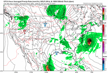
Nothing is completely certain past day 3 and even that can change but, looks like Henri could be close to the Northeast states. Canada, also not out of the woods.
085927_5day_cone_no_line_and_wind.png

Basically, be prepared for anything because this goes from Aug 18 to Aug 24 if it stays on this track.

gfs_mslp_pcpn_frzn_us_fh96-150.gif
 
Last edited:

MrsBlue

Brilliant_Rock
Joined
Jan 30, 2013
Messages
673
oh fudge that looks bad
 

YadaYadaYada

Super_Ideal_Rock
Premium
Joined
Feb 2, 2016
Messages
11,912
Apparently we are getting tropical downpours tomorrow from the remnants of Fred. It’s just as well since we need the rain.
Haven’t seen anything in our weather report about Henri yet, just a brief mention. Maybe we will be spared but we have a long way to go until hurricane season is over :oops2:
 

catcav

Rough_Rock
Joined
Jul 10, 2021
Messages
50
Yikes! That model has it moving right over us in RI.
 

Slickk

Ideal_Rock
Premium
Joined
Jan 3, 2013
Messages
5,013
Oh that does look like a bad path for NE US!! Thanks for the heads up @Arcadian
 

YadaYadaYada

Super_Ideal_Rock
Premium
Joined
Feb 2, 2016
Messages
11,912
@Slick1, if this model holds then we are in for some trouble! I wonder why stations in CT aren’t sounding the alarm.
 

Arcadian

Ideal_Rock
Premium
Joined
Sep 17, 2008
Messages
9,091
@Slick1, if this model holds then we are in for some trouble! I wonder why stations in CT aren’t sounding the alarm.
its because for the most part, they say they don't like to forecast past a 5 day cone. Per the last GFS run, this is still past 5 days.

Basically though, no model agreement that far out. If the next model runs are consistent and come into agreement, thats when you'll hear of a possible skirt of new england.

We know I just like to freak people out.. :lol: ;)2 (no i don't, its just nice to know this stuff honestly!) But even if the eye stays off shore, you guys could still get Tropical Storm force winds as you're on the west side of this storm. However, if its close enough and passes you, then you get the onshore flow which is also something to worry about.

Stay watchful basically.
 

Arcadian

Ideal_Rock
Premium
Joined
Sep 17, 2008
Messages
9,091
Good morning, Henri seems to have some model agreement! Last night there was some interesting discussion about the European models, which went pretty far over my head. It also might be why news stations in the NE weren't ready to pick up on it. They may today considering the message the NHC is putting out, but, I just don't know. Any hit to the NE area is outside the 3 day cone so, it could become quite the nothing burger because of wind shear, a blocking high, whatever. Also remember the cone means the eye could be anywhere in that cone, its not the exact track of the hurricane. (and that means anything outside the storm could get some of it.)

Discussion by NHC.

What you see on NHC is a blend of all the models.
085556_59day_cone_no_line_and_wind.png


To see individual model runs
 

Attachments

  • gfs_mslp_pcpn_frzn_us_fh60-114.gif
    gfs_mslp_pcpn_frzn_us_fh60-114.gif
    2 MB · Views: 8

Arcadian

Ideal_Rock
Premium
Joined
Sep 17, 2008
Messages
9,091
Recon into Henri


I'm seeing images coming out of Worchester, MA that are pretty heartbreaking as the NE deals with remnants of Fred.
204056_5day_cone_no_line_and_wind.png


Agreement is starting to happen. I believe some of the Mid Atlantic states (particularly NJ, DE, and NY) will get some of this but it won't be a full on hit in the way that Sandy was. This will primarily be more or less a NE storm by all accounts taking it on the chin if it continues to strengthen.
 

Lookinagain

Ideal_Rock
Premium
Joined
May 15, 2014
Messages
4,545
Thank you @Arcadian . I've been totally clueless about this. I haven't seen anything on the local news here in Massachusetts. I will start paying more attention.
 

YadaYadaYada

Super_Ideal_Rock
Premium
Joined
Feb 2, 2016
Messages
11,912
So DH might be on call Sunday for the storm. The only way he knew was I gave him a heads up from this thread, so thank you so much @Arcadian for staying on top of it.

Apparently the utility JUST caught on to it today and now they are starting the motions to prepare for the storm. Sunday is all hands on deck.
 

AGBF

Super_Ideal_Rock
Premium
Joined
Jan 26, 2003
Messages
22,146
Fred came through yesterday. I awoke to a raging storm and thought there would be a downpour of monsoon proportions all day. But within a few hours all was calm and dry. That is when I heard (on the radio or television) that we had just received the remnants of Tropical Storm Fred which was passing through.

I never seem to lear about these storms util after they leave nowadays. Maybe because I do not spend enough time o Pricescope! This used to be a great place for weather threads (and appears to be one still). Thanks, @Arcadian. =)2


Deb :wavey:
 

Arcadian

Ideal_Rock
Premium
Joined
Sep 17, 2008
Messages
9,091
Warnings are up. Any news station in the area not reporting on this is crazy.
People in these areas need to prepare NOW even if its a little "wind and rain". Y'all got wind and rain and Worchester and other towns flooded.


092851_5day_cone_no_line_and_wind.png

Recon into Henri (AhnRi which sounds like Onery if you're from the South)

Also some intensity guidance which most models are saying Cat 1. (thats sustained winds over 75MPH)

I told his brother about it and he said the same thing as you guys: no idea and wasn't on the local news (and he lives in Brookline, MA)
 
Last edited:

Arcadian

Ideal_Rock
Premium
Joined
Sep 17, 2008
Messages
9,091
Fred came through yesterday. I awoke to a raging storm and thought there would be a downpour of monsoon proportions all day. But within a few hours all was calm and dry. That is when I heard (on the radio or television) that we had just received the remnants of Tropical Storm Fred which was passing through.

I never seem to lear about these storms util after they leave nowadays. Maybe because I do not spend enough time o Pricescope! This used to be a great place for weather threads (and appears to be one still). Thanks, Arcadian. =)2


Deb :wavey:

I try my best Deb...lol This next one is Sunday, so please prepare and make sure you have needed provisions at your house.
 

AGBF

Super_Ideal_Rock
Premium
Joined
Jan 26, 2003
Messages
22,146
So DH might be on call Sunday for the storm. The only way he knew was I gave him a heads up from this thread, so thank you so much @Arcadian for staying on top of it.

Apparently the utility JUST caught on to it today and now they are starting the motions to prepare for the storm. Sunday is all hands on deck.

I'm right here with you, neighbor! :wavey: Slick1 isn't a nutmegger, but she is close, too.
 

Slickk

Ideal_Rock
Premium
Joined
Jan 3, 2013
Messages
5,013
Ugh ladies!! I’m really nervous about Henri!! Nervous about a lot of things with this but foremost is losing power and having to take in DH’s mom if it’s bad.
We woke up to Fred and torrential rain and a tornado warning!! That never happens around here!! Woke hubby up and he said it’s fine!!! :roll2: Lucky for him, and me, he was right!
I am not a nutmegger but am close enough to frequently shop in your fine state. :hand: Stay safe all!
 

YadaYadaYada

Super_Ideal_Rock
Premium
Joined
Feb 2, 2016
Messages
11,912
From our weather report this morning in CT:

“The hurricane watch is for southern New Haven, southern Middlesex, and southern New London counties.

The tropical storm watch is for Fairfield County.”


A5E82F81-E56D-43EA-AAB3-03D47F381D03.jpeg
 

Arcadian

Ideal_Rock
Premium
Joined
Sep 17, 2008
Messages
9,091
Hi @Slick1 not sure what the news up there is concentrating on but they may be thinking oh, just a tropical storm. But they can do serious damage especially if the ground has been previously saturated. all that water has to go somewhere!

The colder waters up there is what some are counting on to minimize this storm.

Hang in there friend.
 

AprilBaby

Super_Ideal_Rock
Premium
Joined
Jul 17, 2008
Messages
13,253
Meet Henri! 130 lb Bernadoodle age 1. 974AE25A-7298-4E5A-8E07-FEB3C4337D71.jpeg
 

YadaYadaYada

Super_Ideal_Rock
Premium
Joined
Feb 2, 2016
Messages
11,912
OMG so cute @AprilBaby, that’s the kind of Henri I wouldn’t mind coming to visit!
 

AprilBaby

Super_Ideal_Rock
Premium
Joined
Jul 17, 2008
Messages
13,253
My latest grand dog!
 

Slickk

Ideal_Rock
Premium
Joined
Jan 3, 2013
Messages
5,013
@Arcadian I’m close to NYC so that is my news source. Like @YadaYadaYada said, there’s watches and warnings along the coast but you’re right about being complacent. We’ve been knocked out of power for nearly a week many times in the last decade. We have a lot of trees and overhead power lines. Heck, Hurricane Sandy and Floyd (99) devastated us north of the city. Ugh!!! Off to bringing my outdoor items to safety.
You stay safe as well!! :wavey:
 

Slickk

Ideal_Rock
Premium
Joined
Jan 3, 2013
Messages
5,013
@AprilBaby love your fur grand baby!!! Adorable!!
 

bright&shiny

Brilliant_Rock
Joined
May 11, 2009
Messages
1,259
At the moment, it might go right over our heads…. Ugh.
 

Lookinagain

Ideal_Rock
Premium
Joined
May 15, 2014
Messages
4,545
Yep I’ll be clearing off the deck of anything not too heavy to fly around and making sure my lanterns have batteries,etc.
 

Arcadian

Ideal_Rock
Premium
Joined
Sep 17, 2008
Messages
9,091
2pm advisory moved the storm west a tick. next intermediary advisory is 5pm EDT.

TROPICAL STORM HENRI FORECAST/ADVISORY NUMBER 19
NWS NATIONAL HURRICANE CENTER MIAMI FL AL082021
1500 UTC FRI AUG 20 2021

CHANGES IN WATCHES AND WARNINGS WITH THIS ADVISORY...

THE STORM SURGE WATCH HAS BEEN EXTENDED SLIGHTLY WESTWARD TO
FLUSHING NEW YORK...INCLUDING ADJACENT AREAS OF WESTERN LONG
ISLAND SOUND AND THE EAST RIVER.

SUMMARY OF WATCHES AND WARNINGS IN EFFECT...

A STORM SURGE WATCH IS IN EFFECT FOR...
* SOUTH SHORE OF LONG ISLAND FROM EAST ROCKAWAY INLET TO MONTAUK
* NORTH SHORE OF LONG ISLAND FROM KINGS POINT TO MONTAUK
* FLUSHING NEW YORK TO SAGAMORE BEACH MASSACHUSETTS
* NANTUCKET...MARTHA'S VINEYARD...AND BLOCK ISLAND

A HURRICANE WATCH IS IN EFFECT FOR...
* SOUTH SHORE OF LONG ISLAND FROM FIRE ISLAND INLET TO MONTAUK
* NORTH SHORE OF LONG ISLAND FROM PORT JEFFERSON HARBOR TO MONTAUK
* NEW HAVEN CONNECTICUT TO SAGAMORE BEACH MASSACHUSETTS
* NANTUCKET...MARTHA'S VINEYARD...AND BLOCK ISLAND

A TROPICAL STORM WATCH IS IN EFFECT FOR...
* WEST OF FIRE ISLAND INLET TO EAST ROCKAWAY INLET NEW YORK
* WEST OF PORT JEFFERSON HARBOR NEW YORK
* WEST OF NEW HAVEN CONNECTICUT

A STORM SURGE WATCH MEANS THERE IS A POSSIBILITY OF LIFE-
THREATENING INUNDATION...FROM RISING WATER MOVING INLAND FROM THE
COASTLINE...IN THE INDICATED LOCATIONS DURING THE NEXT 48 HOURS.
FOR A DEPICTION OF AREAS AT RISK...PLEASE SEE THE NATIONAL WEATHER
SERVICE STORM SURGE WATCH/WARNING GRAPHIC...AVAILABLE AT
HURRICANES.GOV.

A HURRICANE WATCH MEANS THAT HURRICANE CONDITIONS ARE POSSIBLE
WITHIN THE WATCH AREA. A WATCH IS TYPICALLY ISSUED 48 HOURS
BEFORE THE ANTICIPATED FIRST OCCURRENCE OF TROPICAL-STORM-FORCE
WINDS...CONDITIONS THAT MAKE OUTSIDE PREPARATIONS DIFFICULT OR
DANGEROUS.

A TROPICAL STORM WATCH MEANS THAT TROPICAL STORM CONDITIONS ARE
POSSIBLE WITHIN THE WATCH AREA...GENERALLY WITHIN 48 HOURS.

INTERESTS ELSEWHERE IN THE NORTHEASTERN U.S. AND ATLANTIC CANADA
SHOULD MONITOR THE PROGRESS OF HENRI. ADDITIONAL WATCHES OR
WARNINGS WILL LIKELY BE REQUIRED LATER TODAY.

TROPICAL STORM CENTER LOCATED NEAR 30.4N 73.7W AT 20/1500Z
POSITION ACCURATE WITHIN 25 NM

PRESENT MOVEMENT TOWARD THE NORTHWEST OR 305 DEGREES AT 6 KT

ESTIMATED MINIMUM CENTRAL PRESSURE 996 MB
MAX SUSTAINED WINDS 55 KT WITH GUSTS TO 65 KT.
50 KT....... 50NE 50SE 0SW 0NW.
34 KT....... 80NE 80SE 40SW 60NW.
12 FT SEAS..150NE 90SE 60SW 150NW.
WINDS AND SEAS VARY GREATLY IN EACH QUADRANT. RADII IN NAUTICAL
MILES ARE THE LARGEST RADII EXPECTED ANYWHERE IN THAT QUADRANT.
 

doberman

Ideal_Rock
Premium
Joined
Mar 2, 2012
Messages
2,417
Two days ago I got a loud alert at 2am saying a tornado was in the area, go to the basement, etc. I opened the window and there was no wind at all. Nada, zip, zilch. We live on the east coast, not exactly known for tornados. Then the alert came again and I got no sleep from that point on. Further research showed that the tornado was nowhere near me, I'd have had to drive nearly an hour to get there. Thank you national weather service. Not.
 

YadaYadaYada

Super_Ideal_Rock
Premium
Joined
Feb 2, 2016
Messages
11,912
That slight westward movement now places us in the watch area. It’s going to be a long hurricane season this year o_O
 

YadaYadaYada

Super_Ideal_Rock
Premium
Joined
Feb 2, 2016
Messages
11,912
Updated map for CT, interesting to see how it changed from this morning:

C28121D2-B62B-49F1-9905-26EB9F854646.jpeg
 
Be a part of the community Get 3 HCA Results
Top