shape
carat
color
clarity

Ida in the Gulf

Arcadian

Ideal_Rock
Premium
Joined
Sep 17, 2008
Messages
9,091
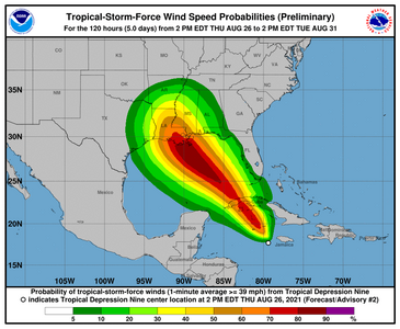
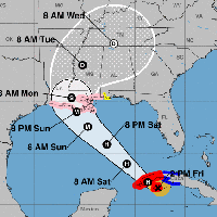
In general I don't like to post these types of storms but its close enough to land to just do it. I don't know who needs to know this, but there's a few no named storms thats rapidly developing in the Caribbean right now. If you're in Texas or Louisiana, pay close attention because at least one could be at your doorstep as early Monday.....and it could blow up into something big. No shear to speak of, extremely good conditions as the gulf is bathtub warm and we're approaching peak week. There's enough model agreement that says it will be something.

gfs_mslp_pcpn_frzn_us_fh90-144.gif

From NHC https://www.nhc.noaa.gov/gtwo.php?basin=atlc&fdays=2
CZC MIATWOAT ALL
TTAA00 KNHC DDHHMM

Tropical Weather Outlook
NWS National Hurricane Center Miami FL
200 PM EDT Wed Aug 25 2021

For the North Atlantic...Caribbean Sea and the Gulf of Mexico:

1. A broad area of low pressure is expected to form over the
southwestern Caribbean Sea during the next day or so from a tropical
wave currently located north of Colombia. Environmental conditions
are forecast to be conducive for development, and a tropical
depression or tropical storm is likely to form late this week or
over the weekend. The system is expected to move northwestward over
the northwestern Caribbean Sea and near or across the Yucatan
Peninsula of Mexico on Friday and into the Gulf of Mexico this
weekend where conditions are expected to be favorable for additional
development. Regardless of development, heavy rainfall and flooding
will be possible through the weekend in portions of Nicaragua,
Honduras, Guatemala, Belize, and the Yucatan Peninsula. In addition,
this system could bring dangerous impacts from storm surge, wind,
and heavy rainfall to portions of the coasts of Louisiana, Texas,
and the Mexican state of Tamaulipas late this weekend and early next
week. However, uncertainty remains large since the system has yet to
form. Interests in these areas should closely monitor the progress
of this system and ensure they have their hurricane plan in place.
An Air Force Reserve reconnaissance aircraft is scheduled to
investigate the system Thursday afternoon, if necessary.
* Formation chance through 48 hours...medium...50 percent.
* Formation chance through 5 days...high...80 percent.
 

Arcadian

Ideal_Rock
Premium
Joined
Sep 17, 2008
Messages
9,091
May they stay no name storms

unfortunately we're coming up on Peak Week with the basin being bathtub warm, relatively low sheer and strong steering currents. So the ingredients are all there. Currently sitting at 90% and will likely get storm status today. Meteorologists that normally don't get worried, are worried. Actual development (being low or high) will mean the difference between a Mexico hit or a US hit. If its a US hit as models suggest, we may well have another Katrina on our hands. Its very rare for Key Statements to be made this early.

ZCZC MIATWOAT ALL
TTAA00 KNHC DDHHMM CCA

Tropical Weather Outlook...Corrected
NWS National Hurricane Center Miami FL
800 AM EDT Thu Aug 26 2021

Corrected 5-day formation probability for the second system

For the North Atlantic...Caribbean Sea and the Gulf of Mexico:

1. Showers and thunderstorms continue to show signs of organization in
association with a broad area of low pressure located over the
west-central Caribbean Sea about 150 miles south-southwest of
Jamaica. Environmental conditions remain conducive for additional
development, and a tropical depression or tropical storm is
expected to form later today or tonight while the system moves
northwestward over the northwestern Caribbean Sea, reaching the
Cayman Islands tonight and western Cuba and the Yucatan Channel
Friday and Friday night. Given the recent developmental trends,
Tropical Storm Warnings for the Cayman Islands and western Cuba
could be required later this morning, and an Air Force Reserve
reconnaissance aircraft is scheduled to investigate the system
this afternoon. Regardless of development, locally heavy rainfall
and flooding are possible over portions of Jamaica and the Cayman
Islands today and tonight, and will likely spread across Cuba
and the Yucatan Peninsula on Friday.

The system is expected to enter into the Gulf of Mexico Friday night
and continue moving northwestward toward the central or northwestern
U.S. Gulf coast, potentially bringing dangerous impacts from storm
surge, wind, and heavy rainfall to portions of the coasts of Texas,
Louisiana, Mississippi, Alabama, and the Florida Panhandle by Sunday
and Monday. However, uncertainty in the system's exact track and
intensity remains large since the low is just beginning to form.
Interests in these areas should closely monitor the progress of this
system and ensure they have their hurricane plans in place.
Additional information on this system, including gale warnings, can
be found in High Seas Forecasts issued by the National Weather
Service.
* Formation chance through 48 hours...high...90 percent.
* Formation chance through 5 days...high...90 percent.
 

Arcadian

Ideal_Rock
Premium
Joined
Sep 17, 2008
Messages
9,091
TD 9 with 3 storms, not sure if its going to be Ida or not.

144701_5day_cone_no_line_and_wind.png

Hurricane Katrina hit Louisiana 8-29-2005 :cry2:
 

Arcadian

Ideal_Rock
Premium
Joined
Sep 17, 2008
Messages
9,091
Hurricane hunters are in the storm right now as time is of the essence. I'll come back if they have anything significant to say, but does look like more Louisana landfall at the moment.

There's a lot of intricacies going on with this, which in part has to do with the upper level low currently over FL, and then the high thats right behind to keep that storm from coming further east. if a storm is big enough (and the model suggestion is a Cat 3 or so), and the high is weaker, the storm will absolutely move east.

The whole season has been weird and its only going to get even more so.
 

Arcadian

Ideal_Rock
Premium
Joined
Sep 17, 2008
Messages
9,091
Edit: They did an update and Ida is now TD9

There appears to be 2 possible hurricanes, a week after another Lets be hopeful that does NOT pan out!!


Tropical Depression Nine Discussion Number 2
NWS National Hurricane Center Miami FL AL092021
500 PM EDT Thu Aug 26 2021

The overall satellite presentation of the tropical cyclone has continued to gradually improve today. Visible imagery and very recent observations from an Air Force Reserve reconnaissance aircraft indicate that the circulation has continued to become better defined. In addition, the convective activity has become a little better organized in a band around the northeastern and eastern portions of the circulation, and the system is likely near tropical storm strength. However, the initial intensity remains 30 kt pending the aircraft fully sampling the eastern portion of the circulation.

The initial motion estimate is northwestward or 325/12 kt. The 1200 UTC dynamical model guidance continues to take the system northwestward around the southwestern side of well-established deep-layer ridge over the western Atlantic. On the forecast track, the system is expected to move over portions of western Cuba late Friday, over the southeastern and central Gulf of Mexico on Saturday, and approach the northern Gulf coast on Sunday. Although the track guidance envelope has tightened this cycle, increasing confidence in the overall forecast scenario, some shifts in the track are still likely until the system consolidates and becomes better defined. Users are reminded to not focus on the exact forecast track as storm surge, wind, and rainfall hazards will extend far from the center, and the average NHC track forecast error at day 3 is around 120 miles. The lastest NHC track forecast is close to the previous official forecast, and lies between the TCVA and HCCA consensus aids.

There is some evidence of some light to moderate southerly shear over the system, but with the cyclone moving over the high ocean heat content waters of the northwestern Caribbean Sea the shear should not hinder intensification, with steady strengthening anticipated during the next 12 to 24 hours. Once the system moves over the Gulf of Mexico, it will be traversing a warm eddy, and this feature, combined with a favorable upper-level wind pattern and a
moist atmosphere, is likely to result in steady to rapid strengthening on Saturday and Saturday night. The NHC intensity forecast again brings the system to near major hurricane strength when it approaches the northern Gulf coast on Sunday.
This is supported by the HWRF and CTCI models, and the global model guidance that has consistently showed significant deepening of the system over the Gulf of Mexico over the past several model cycles. Therefore, as mentioned this morning, there is higher-than-normal confidence that a strengthening tropical cyclone will be moving over the Gulf of Mexico this weekend.

Key Messages:

1. Tropical storm conditions are expected in portions of the Cayman
Islands tonight and in portions of western Cuba and the Isle of
Youth Friday. Dangerous storm surge is possible Friday in portions
of western Cuba, including the Isle of Youth, in areas of onshore
flow.

2. Life-threatening heavy rains, flash flooding and mudslides are
expected across Jamaica, the Cayman Islands, and western Cuba,
including the Isle of Youth.


3. The system is forecast to approach the northern Gulf coast at or
near major hurricane intensity on Sunday, where there is an
increasing risk of life-threatening storm surge, damaging
hurricane-force winds, and heavy rainfall Sunday and Monday,
especially along the coast of Louisiana. Storm Surge and Hurricane
watches will likely be issued for a portion of this area later
tonight or Friday morning. Interests in these areas should closely
monitor the progress of this system and follow any advice given by
local officials.

FORECAST POSITIONS AND MAX WINDS

INIT 26/2100Z 18.0N 79.8W 30 KT 35 MPH
12H 27/0600Z 19.7N 81.0W 45 KT 50 MPH
24H 27/1800Z 21.7N 82.8W 55 KT 65 MPH...INLAND
36H 28/0600Z 23.7N 84.8W 60 KT 70 MPH...OVER WATER
48H 28/1800Z 25.6N 87.0W 70 KT 80 MPH
60H 29/0600Z 27.2N 88.8W 85 KT 100 MPH
72H 29/1800Z 28.9N 90.4W 95 KT 110 MPH
96H 30/1800Z 31.9N 91.4W 50 KT 60 MPH...INLAND
120H 31/1800Z 34.6N 90.0W 25 KT 30 MPH...INLAND

$$
Forecaster Brown

204641_5day_cone_no_line_and_wind.png

204641-png.849703
 

Attachments

  • 204641.png
    204641.png
    72.3 KB · Views: 66
Last edited:

Arcadian

Ideal_Rock
Premium
Joined
Sep 17, 2008
Messages
9,091
I asked for a name change to include the name of the storm for this thread.


Some new updates at 520 PM EDT

336
WTNT64 KNHC 262116
TCUAT4

Tropical Storm Ida Tropical Cyclone Update
NWS National Hurricane Center Miami FL AL092021
520 PM EDT Thu Aug 26 2021

...AIR FORCE PLANE FINDS DEPRESSION A TROPICAL STORM...

Air Force Reserve hurricane hunter aircraft data indicate that the
depression has strengthened to Tropical Storm Ida. The maximum
sustained winds are estimated to be 40 mph (65 km/h) with higher
gusts.


SUMMARY OF 520 PM EDT...2120 UTC...INFORMATION
----------------------------------------------
LOCATION...18.0N 79.8W
ABOUT 100 MI...160 KM WSW OF NEGRIL JAMAICA
ABOUT 130 MI...205 KM SE OF GRAND CAYMAN
MAXIMUM SUSTAINED WINDS...40 MPH...65 KM/H
PRESENT MOVEMENT...NW OR 325 DEGREES AT 14 MPH...22 KM/H
MINIMUM CENTRAL PRESSURE...1006 MB...29.71 INCHES

$$
Forecaster Brown
 

Arcadian

Ideal_Rock
Premium
Joined
Sep 17, 2008
Messages
9,091
And Ida is intensifying and she's a big girl. Hurricane watches are up for Louisiana/Mississippi and parts of Alabama. Hurricane hunters will be in that storm as much as possible today. Predicting a Cat 3 or greater at landfall.

when the winds will arrive (soon...like today for some)
100510_earliest_reasonable_toa_no_wsp_34.png
The cone. Center could be anywhere in this cone, damage can also happen outside of it. No matter where Center is, Louisiana is in big trouble here.
100510_5day_cone_no_line_and_wind.png


Tropical force winds
100510.png

The rain map
100510WPCQPF_sm.gif

The biggest problems will be when this storm comes inland. it will still be a hurricane for a little while and places that don't need that rain (TN) is gonna get even more + tropical force winds.


Airforce Recon
 

Arcadian

Ideal_Rock
Premium
Joined
Sep 17, 2008
Messages
9,091
95
WTNT44 KNHC 270857
TCDAT4

Tropical Storm Ida Discussion Number 4
NWS National Hurricane Center Miami FL AL092021
500 AM EDT Fri Aug 27 2021

Radar data from Grand Cayman and satellite imagery indicate that Ida
is becoming better organized just to the north of Grand Cayman. The
convection has become more concentrated near the center, and the
radar data is showing increasing curved banding. In addition, the
pressure at Grand Cayman fell to 1003 mb, showing that the central
pressure is lower than observed by the aircraft mission yesterday
afternoon.
Based on a combination of the Grand Cayman observations
and satellite intensity estimates from TAFB and SAB, the initial
intensity is increased to 40 kt. Air Force Reserve and NOAA
Hurricane Hunter aircraft are scheduled to investigate Ida near 12Z.

After the earlier wobbling, Ida seems to have resumed a
northwestward motion of 320/13. A mid-level ridge centered off the
southeast U.S. coast is expected to shift westward through the
weekend. This feature should keep Ida moving on a general
northwestward track for the next 2 or 3 days, taking the core of
the system over western Cuba this afternoon or evening and then
across the southern and central Gulf of Mexico this weekend.
Although some model timing differences remain, they are in fairly
good agreement that Ida will make landfall in Louisiana late Sunday
or early Monday. The new forecast track is shifted a little to the
east of the previous forecast through 48 h based on the initial
location. However, the 60 and 72 h positions are similar to the
previous forecast, and thus there is no significant change to the
forecast landfall area in Louisiana at this time.
Users are
reminded to not focus on the exact forecast track as impacts will
extend far from the center and the average 72-hour track error is
around 120 miles.

There continues to be some southwesterly shear affecting Ida due to
the storm's location between an upper-level trough to the west and
an upper-level anticyclone to the east. Some decrease in the shear
is expected during the next 24 h, and that, combined with a moist
environment and warm sea surface temperatures along the forecast
track, should allow steady to rapid strengthening until the cyclone
makes landfall along the northern Gulf coast. The new intensity
forecast is slightly stronger than the previous forecast, and it now
calls for Ida to reach a peak intensity of 100 kt before landfall.

It should be noted that this intensity is lower than that forecast
by the HMON model, the HCCA corrected consensus model, and the
Florida State Superensemble. After landfall, Ida should weaken as
it moves through the lower Mississippi and Tennessee River valleys.
Based on the available guidance, there remains higher-than-normal
confidence that a significant hurricane will approach and impact the
Gulf coast during the weekend and early next week.


Key Messages:

1. Tropical storm conditions are occurring in portions of the Cayman
Islands, and they are expected in portions of western Cuba and the
Isle of Youth today, where a dangerous storm surge is also possible
in areas of onshore flow. Life-threatening heavy rains, flash
flooding and mudslides are expected across Jamaica, the Cayman
Islands, and western Cuba, including the Isle of Youth.

2. There is an increasing risk of life-threatening storm surge
inundation along the coasts of Louisiana, Mississippi, and Alabama,
where a Storm Surge Watch is in effect. Interests in these areas
should follow any advice given by local officials.

3. There is an increasing risk of dangerous hurricane-force winds
beginning Sunday along the portions of the coasts of Louisiana and
Mississippi, including metropolitan New Orleans, where a Hurricane
Watch is in effect.

4. Ida is also expected to produce heavy rains across the central
Gulf Coast from southeast Louisiana to coastal Mississippi, Alabama,
as well as the Lower Mississippi Valley starting Sunday into Monday,
resulting in considerable flash, urban, small stream, and riverine
flooding.


FORECAST POSITIONS AND MAX WINDS

INIT 27/0900Z 20.0N 81.4W 40 KT 45 MPH
12H 27/1800Z 21.5N 82.9W 50 KT 60 MPH...OVER ISLE OF YOUTH
24H 28/0600Z 23.4N 84.9W 60 KT 70 MPH
36H 28/1800Z 25.3N 86.9W 70 KT 80 MPH
48H 29/0600Z 27.1N 88.8W 85 KT 100 MPH
60H 29/1800Z 28.7N 90.2W 100 KT 115 MPH
72H 30/0600Z 30.1N 91.1W 85 KT 100 MPH...INLAND
96H 31/0600Z 33.0N 90.5W 35 KT 40 MPH...INLAND
120H 01/0600Z 35.0N 88.0W 25 KT 30 MPH...INLAND

$$
Forecaster Beven
 

Arcadian

Ideal_Rock
Premium
Joined
Sep 17, 2008
Messages
9,091
Ida is now a hurricane and much faster than forecasted. Things are progressing very fast right about now.
155544_5day_cone_no_line_and_wind.png
 

Slickk

Ideal_Rock
Premium
Joined
Jan 3, 2013
Messages
5,013

Arcadian

Ideal_Rock
Premium
Joined
Sep 17, 2008
Messages
9,091

Arcadian

Ideal_Rock
Premium
Joined
Sep 17, 2008
Messages
9,091
@whitewave I'm hoping you're going to be somewhere safe.
 

Arcadian

Ideal_Rock
Premium
Joined
Sep 17, 2008
Messages
9,091
Big changes. The storm has slowed down. The slower it goes in the gulf the more it intensifies, the bigger it can get.
000
WTNT44 KNHC 272049
TCDAT4

Hurricane Ida Discussion Number 6
NWS National Hurricane Center Miami FL AL092021
500 PM EDT Fri Aug 27 2021

Cuban radar data and reports from an earlier Air Force Reserve
Hurricane Hunter mission indicate that Ida's inner core structure
continued to improve after the release of the previous advisory
package. An eye became apparent in radar imagery before the center
reached the Isle of Youth, and the final fix from the Air Force
Hurricane Hunter aircraft reported a closed 24-n-mi wide eye. The
aircraft measured winds to support hurricane intensity shortly
before 1800 UTC, and during the final northeast eyewall pass, and
flight-level wind data support increasing the intensity to 70 kt,
which is used as the initial intensity for this advisory.


The upper-level outflow has expanded over all but the southwestern
portion of the circulation, and the upper-level wind pattern is
forecast to continue to improve overnight and early Saturday.
Once Ida moves past western Cuba and into the southeastern Gulf of
Mexico, it will be moving through a very favorable oceanic and
atmospheric environment consisting of high ocean heat content
waters, low vertical wind shear, and a moist low- to mid-level
atmosphere. These conditions are likely to result in a period
of rapid strengthening during the next 24 to 36 hours. In fact,
with the higher initial wind speed, the intensity guidance has
significantly increased this cycle, and the bulk of the guidance
now brings Ida to category 4 intensity.
The NHC forecast explicitly
calls for rapid intensification during the next 24 to 36 hours,
which is supported by several of the dynamical models, the LGEM
model, and high probabilities of rapid intensification indicated
by the SHIPS and DTOPS RI guidance. The NHC forecast is near
the IVCN multi-model consensus aid, but is lower than HCCA and
LGEM. It should be noted that some fluctuations in intensity are
possible as Ida nears the northern Gulf coast due to possible
eyewall replacement cycles. In addition to the expected increase in
strength, the dynamical model guidance again calls for Ida's wind
field to expand while it moves over the Gulf of Mexico. As a
result, there is higher-than-normal confidence that a large and
powerful hurricane will impact portions of the northern Gulf coast
by late this weekend and early next week.

Ida has wobbled a little right of the previous track, but the longer
term motion continues to be northwestward or 320/13 kt. The steering
currents remain well-established as a strong deep-layer ridge over
the western Atlantic should continue to steer Ida northwestward
across the Gulf this weekend. Ida will approach the western
portion of the ridge after landfall, and this should result in a
slower northward motion by day 3.
After that time, a short-wave
trough over the central United States is expected to cause the
system to turn northeastward. The track guidance remains in
remarkably good agreement through landfall along the northern Gulf
coast, and there is higher-than-normal confidence in that portion of
the track forecast. However, users are again reminded to not focus
on the exact details of the track forecast as storm surge, wind,
and rainfall impacts will extend far from the center.

Key Messages:

1. Life-threatening storm surge and hurricane conditions are
expected to continue through tonight in portions of western Cuba,
including the Isle of Youth, where a Hurricane Warning is in effect.
Life-threatening heavy rains, flash flooding and mudslides are
expected across Jamaica, the Cayman Islands, and western Cuba,
including the Isle of Youth.

2. There is a danger of life-threatening storm surge inundation
Sunday along the coasts of Louisiana and Mississippi within the
Storm Surge Warning area. Extremely life-threatening inundation of
10 to 15 feet above ground level is possible within the area from
Morgan City, Louisiana, to the Mouth of the Mississippi River.
Interests throughout the warning area should follow any advice given
by local officials.

3. Ida is expected to be an extremely dangerous major hurricane when
it reaches the coast of Louisiana. Hurricane-force winds are
expected Sunday in portions of the Hurricane Warning area along the
Louisiana coast, including metropolitan New Orleans, with
potentially catastrophic wind damage possible where the core of Ida
moves onshore. Actions to protect life and property should be rushed
to completion in the warning area.

4. Ida is likely to produce heavy rainfall later Sunday into Monday
across the central Gulf Coast from southeast Louisiana to coastal
Mississippi and Alabama, resulting in considerable flash, urban,
small stream, and riverine flooding impacts. As Ida moves inland,
flooding impacts are possible across portions of the Lower
Mississippi and Tennessee Valleys.

FORECAST POSITIONS AND MAX WINDS

INIT 27/2100Z 22.1N 83.2W 70 KT 80 MPH
12H 28/0600Z 23.5N 84.8W 85 KT 100 MPH
24H 28/1800Z 25.3N 86.9W 105 KT 120 MPH
36H 29/0600Z 27.1N 89.0W 115 KT 130 MPH
48H 29/1800Z 28.6N 90.6W 120 KT 140 MPH <---this is at landfall!
60H 30/0600Z 30.0N 91.3W 80 KT 90 MPH...INLAND
72H 30/1800Z 31.5N 91.1W 40 KT 45 MPH...INLAND
96H 31/1800Z 34.4N 89.3W 30 KT 35 MPH...INLAND
120H 01/1800Z 36.0N 86.0W 20 KT 25 MPH...POST-TROP/REMNT LOW

$$
Forecaster Brown

155544_earliest_reasonable_toa_no_wsp_34.png
155544WPCQPF_sm.gif
1155544_5day_cone_no_line_and_wind.png

Recon continues as much as they can to get the data needed for this storm.
 

tyty333

Super_Ideal_Rock
Premium
Joined
Dec 17, 2008
Messages
27,278
Ugh...hoping those in the path are either out of there or are preparing to buckle down. Hope all stay safe.
 

Arcadian

Ideal_Rock
Premium
Joined
Sep 17, 2008
Messages
9,091
@Lula I've been doing some reading on this and its very heart breaking. I'm hoping these hospitals are ready for whats coming.

Of course what I'm most pissed about is Mayor of New Orleans has done. While its a quick moving storm they had Thursday and Friday to start evacuating people and they didn't call a mandatory, where some, if they had called it, would not have risked their jobs. They also knew that some of the levies were not ready.

Not making this political but there could be a large loss of life where it could have been prevented. My cousin from California was planing to be in NOLA area for vacation as they have a home there. On Tuesday I told her to cancel her plans and I showed her why. That was before I even posted here because...family. Thankfully she paid attention!

And Ida made it past Cuba with barely a hiccup and well organized. Recon is now ongoing

NHC Discussion


554
WTNT44 KNHC 280859
TCDAT4

Hurricane Ida Discussion Number 8
NWS National Hurricane Center Miami FL AL092021
400 AM CDT Sat Aug 28 2021

Just after the last advisory, the convective structure of Ida got a
bit ragged, probably due to the residual effects of land
interaction with Cuba and a tongue of dry air that wrapped into the
eastern side of the circulation. However, latest radar images from
Cuba show that the eye is becoming better defined, and satellite
imagery shows cooling of the cloud tops in the eyewall.
The
initial intensity has been held at 70 kt based on the latest trends
and earlier Hurricane Hunter aircraft data. NOAA and Air Force
reserve Hurricane Hunter aircraft are scheduled to investigate Ida
again starting around 12Z.

The initial motion remains northwestward or 315/14. A subtropical
ridge centered off the southeast U.S. coast is expected to shift
westward through the weekend, and this feature should continue to
provide a steering flow that will take Ida steadily northwestward
across the Gulf of Mexico during the next 36-48 h. The track
guidance remains in good agreement that Ida will make landfall on
the coast of southeastern or central Louisiana late Sunday or early
Monday morning. After landfall, Ida is expected to turn northward
through Louisiana and western Mississippi at a slower forward speed
as it moves around the western end of the ridge. Recurvature into
the westerlies and an east-northeastward motion are expected by the
end of the forecast period.
The new forecast track is nudged
slightly to the west after 36 h to keep it near the various
consensus models, but this is not a significant change from the
previous forecast. Users are again reminded to not focus on the
exact details of the track forecast as storm surge, wind, and
rainfall impacts will extend far from the center.

Ida is expected to remain in a favorable environment of light
vertical shear and very warm sea-surface temperatures until it
makes landfall. The only negative factor is the possibility that
dry air may try to entrain into the system and slow the expected
intensification. The SHIPS and LGEM models are showing a little
less strengthening than previously. However, the HWRF and HMON
models continue to forecast Ida to reach Category 4 intensity
before landfall. The new intensity forecast will forecast a peak
intensity of 120 kt in best agreement with the HWRF and HMON, and
the pre-landfall part of the forecast is little changed from the
previous forecast. After landfall, rapid weakening is expected due
to land interaction, drier air, and an increase in shear, and Ida
is expected to become a post-tropical cyclone as it moves through
the Tennessee Valley.

As Ida continues to intensify over the Gulf of Mexico, an expansion
of its wind field is predicted.
The NHC wind radii forecast is
largely based on the radii consensus, and winds of at least tropical
storm force are likely to reach the coast Sunday morning. Therefore,
all preparations to protect life and property for this dangerous
event need to be made today.


Key Messages:

1. Hurricane and tropical storm conditions are ending over Cuba.
However, Ida will continue to bring periods of heavy rain across
western Cuba through today that may lead to flash flooding and
mudslides.

2. There is a danger of life-threatening storm surge inundation
Sunday along the coasts of Louisiana and Mississippi within the
Storm Surge Warning area. Extremely life-threatening inundation of
10 to 15 feet above ground level is possible within the area from
Morgan City, Louisiana, to the Mouth of the Mississippi River.
Interests throughout the warning area should follow any advice given
by local officials.

3. Ida is expected to be an extremely dangerous major hurricane when
it reaches the coast of Louisiana. Hurricane-force winds are
expected Sunday in portions of the Hurricane Warning area along the
Louisiana coast, including metropolitan New Orleans, with
potentially catastrophic wind damage possible where the core of Ida
moves onshore. Actions to protect life and property should be rushed
to completion in the warning area.

4. Ida is likely to produce heavy rainfall later Sunday into Monday
across the central Gulf Coast from southeast Louisiana to coastal
Mississippi resulting in significant flash and riverine flooding
impacts. As Ida moves inland, flooding impacts are possible across
portions of the Lower Mississippi and Tennessee Valleys.


FORECAST POSITIONS AND MAX WINDS

INIT 28/0900Z 24.0N 85.2W 70 KT 80 MPH
12H 28/1800Z 25.4N 86.9W 85 KT 100 MPH
24H 29/0600Z 27.1N 88.9W 105 KT 120 MPH
36H 29/1800Z 28.6N 90.5W 120 KT 140 MPH< --Landfall
48H 30/0600Z 30.1N 91.3W 85 KT 100 MPH...INLAND

60H 30/1800Z 31.6N 91.2W 45 KT 50 MPH...INLAND
72H 31/0600Z 33.2N 90.5W 30 KT 35 MPH...INLAND
96H 01/0600Z 36.0N 87.0W 25 KT 30 MPH...INLAND
120H 02/0600Z 37.5N 82.5W 20 KT 25 MPH...POST-TROP/REMNT LOW

$$
Forecaster Beven
 

MrsBlue

Brilliant_Rock
Joined
Jan 30, 2013
Messages
673
The decision has been made to not evacuate the hospitals. Because there is nowhere to take the patients - all surrounding area hospitals are full of Covid patients. And more Covid coming - the shelters are full.

Horrendous situation. Nightmarish.
 

Arcadian

Ideal_Rock
Premium
Joined
Sep 17, 2008
Messages
9,091
No real track changes Unless something happens between now and 5pm, I won't post anything else.

Recon data


000
WTNT44 KNHC 281457
TCDAT4

Hurricane Ida Discussion Number 9
NWS National Hurricane Center Miami FL AL092021
1000 AM CDT Sat Aug 28 2021

The satellite presentation of Ida has continued to improve this
morning with the center embedded within a fairly symmetric Central
Dense Overcast and hints of the eye in both visible in infrared
satellite imagery. Earlier microwave imagery revealed a well-
defined low- to mid-level eye and excellent spiral banding over the
northern semicircle. Both NOAA and Air Force Reserve hurricane
hunter aircraft, somewhat surprisingly, have not found a
significantly deepening tropical cyclone yet, but given the very
recent increase in organization and structure, the winds are likely
to catch up to the satellite appearance very soon.
Using the latest
flight-level and SFMR wind data from the aircraft and satellite
intensity estimates the initial wind speed remains 75 kt for this
advisory. The aircraft data does indicate that Ida's wind field has
expanded, and the NHC wind radii have been adjusted accordingly.


Given the improved inner-core structure Ida appears poised to
rapidly intensify during the next 12 to 24 hours as it remains
within a favorable environment of low vertical wind shear and over
warm water. Although the interpolated intensity guidance has
lowered somewhat due to the fact that Ida has not significantly
strengthened yet, the explicit forecasts from the dynamical models
continue to support significant deepening, and the latest runs of
the HWRF and HMON models indicate Ida will reach Category 4 strength

before landfall. The new NHC intensity forecast calls for rapid
intensification to Category 4 strength during the next 24 hours.

After that time, fluctuations in intensity are possible due to
eyewall replacement cycles as Ida approaches the northern Gulf
coast. After landfall, rapid weakening is expected and Ida is
forecast to weaken to a tropical depression by Monday night, and
become a post-tropical cyclone as it moves over the Tennessee Valley
by mid-week.

Ida has been moving steadily northwestward or 315/14 kt. A deep
layer ridge near the southeastern United States coast is forecast to
shift westward during the next day or so, and this should continue
to steer Ida northwestward through landfall on Sunday. The track
guidance remains in remarkably good agreement through 36 hours, and
the new NHC track forecast is essentially unchanged during that
time, and continues to indicate that Ida will reach the coast of
Louisiana on Sunday. After landfall, Ida will be near the western
extent of the ridge and should turn northward and then northeastward
as it recurves into the southern portion of the mid-latitude
westerlies. The track guidance has shifted slightly westward beyond
48 hours, and the track forecast over the southern U.S. and the
Tennessee Valley has been adjusted accordingly. Users are again
reminded to not focus on the exact details of the track forecast as
storm surge, wind, and rainfall impacts will extend far from the
center. Wind and rainfall impacts will also penetrate inland
through early next week after Ida makes landfall.


Key Messages:

1. There is a danger of life-threatening storm surge inundation
Sunday along the coasts of Louisiana and Mississippi within the
Storm Surge Warning area. Extremely life-threatening inundation of
9 feet or greater above ground level is possible somewhere within
the area from Morgan City, Louisiana, to the coast of Mississippi.
Overtopping of local levees outside of the Hurricane and Storm
Damage Risk Reduction System is possible where local inundation
values may be higher.
Interests throughout the warning area should
follow any advice given by local officials.

2. Ida is expected to be an extremely dangerous major hurricane when
it reaches the coast of Louisiana. Hurricane-force winds are
expected Sunday in portions of the Hurricane Warning area along the
Louisiana coast, including metropolitan New Orleans, with
potentially catastrophic wind damage possible where the core of Ida
moves onshore. Actions to protect life and property should be rushed
to completion today in the warning area.

3. Ida is likely to produce heavy rainfall Sunday and Monday across
the central Gulf Coast from southeast Louisiana to coastal
Mississippi, resulting in life-threatening flash and urban flooding
and significant river flooding impacts. As Ida moves inland,
significant flooding impacts are likely across portions of the Lower
Mississippi and Tennessee Valleys Monday and Tuesday.

FORECAST POSITIONS AND MAX WINDS

INIT 28/1500Z 24.8N 86.1W 75 KT 85 MPH
12H 29/0000Z 26.3N 87.9W 100 KT 115 MPH
24H 29/1200Z 28.0N 89.8W 115 KT 130 MPH
36H 30/0000Z 29.4N 91.0W 115 KT 130 MPH...INLAND

48H 30/1200Z 31.0N 91.5W 60 KT 70 MPH...INLAND
60H 31/0000Z 32.7N 91.0W 30 KT 35 MPH...INLAND
72H 31/1200Z 34.4N 89.8W 25 KT 30 MPH...INLAND
96H 01/1200Z 36.8N 85.3W 20 KT 25 MPH...POST-TROP/INLAND
120H 02/1200Z 37.9N 79.9W 20 KT 25 MPH...POST-TROP/INLAND

$$
Forecaster Brown
 

Arcadian

Ideal_Rock
Premium
Joined
Sep 17, 2008
Messages
9,091
Storm now 105MPH and storm is ticking slightly east.

Per the 4PM CDT discussion, there's some ticking down of the speeds. Thats not to say they won't go back up and not to say they will have a downward trend, the issue right now is

7 hours of daylight left today. And the storm will continue to intensify and get bigger during these hours.

Tropical tidbits is having a bit of a problem keeping up with all the traffic so won't link to there right now.


Air recons will be continuing however But even they had to evacuate to keep the planes and themselves safe


I'm posting this because...well we know why. This is so unacceptable....
 

Arcadian

Ideal_Rock
Premium
Joined
Sep 17, 2008
Messages
9,091
Ida has now a pressure of 966, which I certainly can feel it. the storm has a bigger windfield which is bad because it means more intensity when it comes on shore over a larger area. I'm going to go to bed, its been rough day with all this crazy pressure banging around my head. still 105MPH but expected to catch up to its dropping pressure. it goes over its warmest water tonight into tomorrow.
 

HollyJane

Shiny_Rock
Joined
Apr 7, 2020
Messages
223
Thank you for all your posting on this. I am in an area that will be affected, to what extent I am not sure.
Ida has now a pressure of 966, which I certainly can feel it. the storm has a bigger windfield which is bad because it means more intensity when it comes on shore over a larger area. I'm going to go to bed, its been rough day with all this crazy pressure banging around my head. still 105MPH but expected to catch up to its dropping pressure. it goes over its warmest water tonight into tomorrow.
 

missy

Super_Ideal_Rock
Premium
Joined
Jun 8, 2008
Messages
54,170
Sending good wishes to all who are affected. May you be safe and well. I am keeping you in my thoughts.
 

Slickk

Ideal_Rock
Premium
Joined
Jan 3, 2013
Messages
5,013
thanks @Arcadian for the updates. I also feel low pressure systems in my bones. I hope you feel better when you wake up today!
Sending good wishes to all in Ida’s path…
 

Arcadian

Ideal_Rock
Premium
Joined
Sep 17, 2008
Messages
9,091
Ida is near150MPH and still getting stronger. this is going to be bad

000
WTNT64 KNHC 291057
TCUAT4

Hurricane Ida Tropical Cyclone Update
NWS National Hurricane Center Miami FL AL092021
600 AM CDT Sun Aug 29 2021

...NOAA PLANE FINDS IDA STRONGER...
...EXTREMELY DANGEROUS CATEGORY 4 HURRICANE IDA EXPECTED TO MAKE
LANDFALL IN SOUTHEASTERN LOUISIANA LATER TODAY...

Reports from a NOAA Hurricane Hunter aircraft indicate that maximum
sustained winds have increased to near 150 mph (240 km/h) with
higher gusts. The latest minimum central pressure estimated from
reconnaissance aircraft data is 935 mb (27.61 in).


An elevated NOAA C-MAN station at Pilot's Station East near
Southwest Pass, Louisiana, recently reported a sustained wind of 82
mph (131 km/h) and a gust to 107 mph (172 km/h). Another NOAA
elevated C-MAN station at Southwest Pass recently reported a
sustained wind of 77 mph (124 km/h) and a wind gust of 93 mph (150
km/h).


SUMMARY OF 600 AM CDT...1100 UTC...INFORMATION
----------------------------------------------
LOCATION...28.3N 89.4W
ABOUT 75 MI...120 KM SSE OF GRAND ISLE LOUISIANA
ABOUT 60 MI...95 KM SSW OF THE MOUTH OF THE MISSISSIPPI RIVER
MAXIMUM SUSTAINED WINDS...150 MPH...240 KM/H
PRESENT MOVEMENT...NW OR 315 DEGREES AT 15 MPH...24 KM/H
MINIMUM CENTRAL PRESSURE...935 MB...27.61 INCHES

$$
Forecaster Brown/Brennan
 

Arcadian

Ideal_Rock
Premium
Joined
Sep 17, 2008
Messages
9,091
Thank you for all your posting on this. I am in an area that will be affected, to what extent I am not sure.

I'm praying for you. I'm being very sincere. Please keep in touch so we know you're OK as this is going to not be a good situation.
 

Arcadian

Ideal_Rock
Premium
Joined
Sep 17, 2008
Messages
9,091
For anyone paying attention Ida is deepening still. Hurricane hunters look to be finding higher wind speeds. Someone said they're flagging those so I believe they're being cautious on calling cat 5 status. The water Ida is going over is very much like being in a bathtub and thats fuel for a storm this large.
 

Arcadian

Ideal_Rock
Premium
Joined
Sep 17, 2008
Messages
9,091
7am CDT advisory has the pressure at 933mb officially. it will not be surprising to see something that falls as it gets stronger. So 160MPH and some gusts are 185MPH (my house could not survive these gusts)

It will not be surprising if they call it a Cat 5 at the next advisory.

000
WTNT44 KNHC 291158
TCDAT4

Hurricane Ida Special Discussion Number 13
NWS National Hurricane Center Miami FL AL092021
700 AM CDT Sun Aug 29 2021

Recent reports from both NOAA and Air Force Reserve Hurricane Hunter
aircraft indicate that Ida has continued to strengthen since the
0900 UTC advisory and the maximum winds are estimated to be 130
kt. This intensity is based on peak 700-mb flight-level winds of
146 kt that have been reported by both aircraft and believable SFMR
winds of around 130 kt. The NOAA aircraft very recently reported
that the minimum pressure has fallen to around 933 mb. This special
advisory is issued to raise the 12-hour forecast intensity to 135
kt, but it is possible that Ida could peak slightly above that
before landfall occurs.

The initial motion estimate is 320/13 kt, slightly faster than
the previous forecast. Therefore, the 12-hour forecast point has
also been adjusted slightly. No other changes were made to the
track or intensity forecasts.

The initial and forecast 64-kt wind radii were adjusted outward in
the northeast and southeast quadrants based on aircraft data.

Note that this Special advisory replaces the regular 1200 UTC (700
AM CDT) intermediate public advisory.

Key Messages:

1. Extremely life-threatening storm surge inundation of 9 feet or
greater above ground level is imminent somewhere within the area
from Burns Point, Louisiana, to Ocean Springs, Mississippi.
Overtopping of local levees outside of the Hurricane and Storm
Damage Risk Reduction System is possible where local inundation
values may be higher. Interests throughout the Storm Surge Warning
area should follow any advice given by local officials.

2. Catastrophic wind damage is likely where the core of Ida moves
onshore along the southeast coast of Louisiana in the next few
hours. Hurricane-force winds are expected today within the Hurricane
Warning area along the Louisiana coast, including metropolitan New
Orleans.

3. Damaging winds, especially in gusts, will spread inland near the
track of the center of Ida across portions of southeastern Louisiana
and southwestern Mississippi today through early Monday. These winds
will likely lead to widespread tree damage and power outages.

4. Ida will produce heavy rainfall today through Monday across the
central Gulf Coast from southeastern Louisiana, coastal Mississippi,
to far southwestern Alabama resulting in considerable to life-
threatening flash and urban flooding and significant river flooding
impacts. As Ida moves inland, significant flooding impacts are
possible across portions of the Lower Mississippi, Tennessee, and
Ohio Valleys through Wednesday.

FORECAST POSITIONS AND MAX WINDS

INIT 29/1200Z 28.5N 89.6W 130 KT 150 MPH
12H 29/1800Z 29.2N 90.4W 135 KT 155 MPH
24H 30/0600Z 30.6N 91.1W 70 KT 80 MPH...INLAND
36H 30/1800Z 32.2N 91.0W 45 KT 50 MPH...INLAND
48H 31/0600Z 33.8N 90.0W 30 KT 35 MPH...INLAND
60H 31/1800Z 35.4N 87.9W 25 KT 30 MPH...INLAND
72H 01/0600Z 36.7N 85.2W 20 KT 25 MPH...INLAND
96H 02/0600Z 38.9N 78.9W 20 KT 25 MPH...POST-TROP/INLAND
120H 03/0600Z...DISSIPATED

$$
Forecaster Brown/Brennan
 

Arcadian

Ideal_Rock
Premium
Joined
Sep 17, 2008
Messages
9,091
@Slick1 I still have a headache though its not as bad because the storm is further north. When Dorian was outside our door in the Bahamas I was ill, literally. That was an enormous storm.

For Ida, Central pressure is now lower than 930MB is whats being found by Hurricane hunters, so unofficially its a Cat 5. I heard it will come onshore around Houma, LA

Lots of damage with this storm well outside the cone. West coast of FL and the pan handle is getting rain bands that will not be very nice.
 
Be a part of the community Get 3 HCA Results
Top