shape
carat
color
clarity

You want storms? We have storms.

Arcadian

Ideal_Rock
Premium
Joined
Sep 17, 2008
Messages
9,105
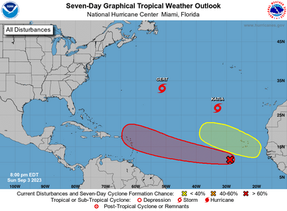
CONUS, this will be the next watchable storm (50%) In general I hate saying anything THIS early, but I saw a couple of model runs that says it could be something.

If it develops early enough then it goes and the high does not build back, it stays east and goes north like Katia. If it develops late and the high ridge builds back in over the Atlantic (Bermuda High), it goes west.

Low riders like this tend to stay low past a certain point. Still I'm hoping for a nothing and it fizzles.

Peak of the season is next week.
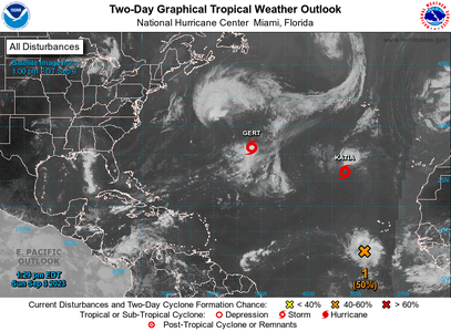
two_atl_2d09-3-2023.png
 

Arcadian

Ideal_Rock
Premium
Joined
Sep 17, 2008
Messages
9,105
After bigger storms like the last one, people try to be first to the next big storm. Sadly. Its good and bad in so me ways. There's a lot of cleanup after this last one but unfortunate is that our red one there may be trying to develop and quickly. Nothing ever gets locked in this far out but I'm not liking where this thing is trending.

two_atl_7d09-3-2023.png
ZCZC MIATWOAT ALL
TTAA00 KNHC DDHHMM

Tropical Weather Outlook
NWS National Hurricane Center Miami FL
800 PM EDT Sun Sep 3 2023

For the North Atlantic...Caribbean Sea and the Gulf of Mexico:

Active Systems:
The National Hurricane Center is issuing advisories on Tropical
Storm Gert, located over the central subtropical Atlantic, and
Tropical Storm Katia, located over the eastern subtropical Atlantic.

1. Central Tropical Atlantic (AL95): (in red)
Showers and thunderstorms are showing signs of organization in
association with a tropical wave located several hundred miles
southwest of the Cabo Verde Islands. Environmental conditions are
forecast to be conducive for further development, and this system is
expected to become a tropical depression in two or three days.
Additional strengthening is likely late this week while the system
moves westward to west-northwestward at 15 to 20 mph over the
central and western portions of the tropical Atlantic.
* Formation chance through 48 hours...medium...60 percent.
* Formation chance through 7 days...high...90 percent.


2. Eastern Tropical Atlantic: (in yellow)
A tropical wave over western Africa is forecast to move offshore in
a couple of days. Environmental conditions could support some slow
development starting midweek while the wave moves to the west-
northwest at about 15 mph over the far eastern tropical Atlantic.
* Formation chance through 48 hours...low...near 0 percent.
* Formation chance through 7 days...low...30 percent.

Forecaster Cangialosi
 

Arcadian

Ideal_Rock
Premium
Joined
Sep 17, 2008
Messages
9,105
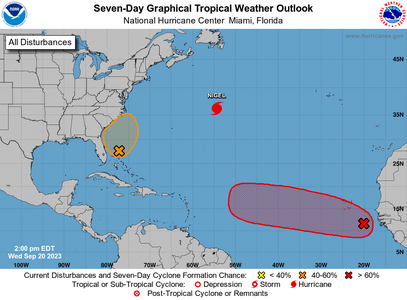
There's something going on.
1695233113660.png


ZCZC MIATWOAT ALL
TTAA00 KNHC DDHHMM

Tropical Weather Outlook
NWS National Hurricane Center Miami FL
200 PM EDT Wed Sep 20 2023

For the North Atlantic...Caribbean Sea and the Gulf of Mexico:

Active Systems:
The National Hurricane Center is issuing advisories on Hurricane
Nigel, located over the central subtropical Atlantic.

1. Eastern Tropical Atlantic:
A tropical wave is currently located a couple of hundred miles
southeast of the Cabo Verde Islands. This system is expected
to merge with another disturbance located a few hundred miles to its
west in a few days. Environmental conditions are forecast to
be conducive for gradual development, and a tropical depression is
likely to form late this week or this weekend while the system moves
generally westward at 10 to 15 mph across the eastern and central
tropical Atlantic.
* Formation chance through 48 hours...low...10 percent.
* Formation chance through 7 days...high...70 percent.

2. Western Atlantic:
A non-tropical low pressure system is expected to form within a
large area of disorganized showers and thunderstorms to the east
of the Florida peninsula within the next day or two. This system
could acquire some subtropical characteristics on Friday while it
moves generally northward. Regardless of development, this low is
likely to bring gusty winds to gale force, heavy rain, and high surf
to portions of the Southeast and Mid-Atlantic United States late
this week and into this weekend. Additional information on this
system can be found in High Seas Forecasts and products from your
local National Weather Service office.
* Formation chance through 48 hours...low...10 percent.
* Formation chance through 7 days...medium...40 percent.

High Seas Forecasts issued by the National Weather Service
can be found under AWIPS header NFDHSFAT1, WMO header FZNT01
KWBC, and online at ocean.weather.gov/shtml/NFDHSFAT1.php

Forecaster Pasch
 

Arcadian

Ideal_Rock
Premium
Joined
Sep 17, 2008
Messages
9,105
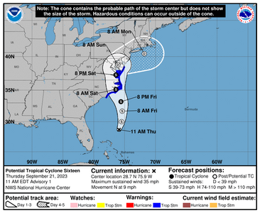
North Carolina, Mid atlantic states and parts of the NE on this one. Should not be anything big, but could be a flood maker.
1695317424950.png


000
WTNT41 KNHC 211503
TCDAT1

Potential Tropical Cyclone Sixteen Discussion Number 1
NWS National Hurricane Center Miami FL AL162023
1100 AM EDT Thu Sep 21 2023

A broad non-tropical area of low pressure has formed well east of
the east coast of Florida this morning. Although this system is
forecast to remain non-tropical during the next 12-24 hours, the
dynamical model guidance indicates that it will likely acquire
tropical characteristics late Friday and early Saturday as it
approaches the coast of North Carolina. Although it is unclear as
to whether the cyclone detaches from a front that is forecast to
extend northeastward from the center, the guidance suggests a
tropical-cyclone like core and structure when it nears the coast.
As a result, advisories are being initiated on Potential Tropical
Cyclone Sixteen to issue Tropical Storm Warnings and Storm Surge
Watches for portions of the coasts of North Carolina, Virginia and
Maryland. Winds associated with the front farther north are being
covered by non-tropical products issued by local National Weather
Service offices and the Ocean Prediction Center. Additional
tropical watches and warnings could be issued for other portions of
the Chesapeake Bay later today.

Since the low is still in its formative stage, the initial motion
estimate is a highly uncertain 360/8 kt. The model guidance
suggests that center reformations are likely to occur during the
next day or so, but the overall motion of the system is expected to
be a little east of due north. As the system interacts with a
mid-latitude trough that it becomes embedded within, a bend toward
the north-northwest is forecast. That motion should bring the
center over eastern North Carolina within the warning area Saturday
morning. The NHC track forecast follows a blend of the various
global models that are in good agreement.

The system is forecast to gradually strengthen during the next 24
hours. After that time, the guidance suggests it is likely to form
a smaller inner core with additional strengthening expected until
the center reaches the coast. The NHC intensity forecast follows
the ECMWF and GFS models trends.

Key Messages:

1. An area of low pressure is forecast to develop off the
southeastern U.S. coast later today and will bring
tropical-storm-force winds, storm surge, heavy rain, and high surf
to large portions of the southeast and mid-Atlantic United States
coast beginning Friday and continuing into the weekend.

2. There is the potential for life-threatening storm surge
inundation from Surf City, North Carolina to Chincoteague, Virginia,
the Pamlico and Albemarle Sounds, and the lower Chesapeake Bay.
Residents in these areas should follow advice given by local
officials.

3. Tropical storm conditions are expected within portions of the
southeast and mid-Atlantic coasts within the Tropical Storm Warning
area beginning on Friday and continuing into Saturday.

4. Heavy rainfall from this system could produce localized urban
and small stream flooding impacts across the eastern mid-Atlantic
states from North Carolina to New Jersey Friday through Sunday.

FORECAST POSITIONS AND MAX WINDS

INIT 21/1500Z 28.7N 75.9W 30 KT 35 MPH...POTENTIAL TROP CYCLONE
12H 22/0000Z 30.0N 75.5W 35 KT 40 MPH...POTENTIAL TROP CYCLONE
24H 22/1200Z 31.7N 75.4W 45 KT 50 MPH...POTENTIAL TROP CYCLONE
36H 23/0000Z 33.2N 75.6W 50 KT 60 MPH...TROPICAL CYCLONE
48H 23/1200Z 35.1N 76.4W 50 KT 60 MPH...TROPICAL CYCLONE
60H 24/0000Z 37.3N 76.4W 40 KT 45 MPH...TROPICAL CYCLONE
72H 24/1200Z 38.8N 76.1W 30 KT 35 MPH...POST-TROPICAL
96H 25/1200Z 40.4N 71.8W 25 KT 30 MPH...POST-TROPICAL
120H 26/1200Z...DISSIPATED

$$
Forecaster Brown
 

Arcadian

Ideal_Rock
Premium
Joined
Sep 17, 2008
Messages
9,105
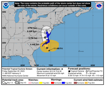
1695404583288.png
000
WTNT41 KNHC 221453
TCDAT1

Potential Tropical Cyclone Sixteen Discussion Number 5
NWS National Hurricane Center Miami FL AL162023
1100 AM EDT Fri Sep 22 2023

Surface observations indicate the low pressure system off the
southeast U.S. coast is deepening this morning. Recent pressure and
wind data from NOAA buoy 41002 suggest the pressure has fallen to
around 996 mb. While surface analyses indicate there is still a
front in close proximity to the low, deep convection has become more
concentrated to the north of the center. In fact, GOES-16 1-min
visible imagery suggests the low-level center is re-forming closer
to the convection. The broad wind field is asymmetric, with the
strongest observed winds occurring to the north and west of the
frontal feature. A NOAA Saildrone sampling the system reported a
sustained wind of 40 kt and a gust around 50 kt earlier this
morning. Based on the available observations, the initial intensity
is held at 45 kt. An Air Force Reserve Hurricane Hunter aircraft is
scheduled to investigate the system this afternoon.

The initial motion of the cyclone is just west of due north (350/10
kt). The system is forecast to move north-northwestward to northward
through Saturday along the west side of a subtropical ridge over the
western and central Atlantic. This motion will take the center of
the cyclone inland over eastern North Carolina on Saturday morning
and over the Mid-Atlantic region Saturday night and Sunday. The
track guidance is in good agreement for this forecast. Based on the
slight northward adjustment to the initial position, the updated NHC
forecast is slightly faster than the previous one, showing the
cyclone center just inland in 24 h.

Based on recent satellite and observational trends, the cyclone
appears likely to strengthen during the next 12 h over the warm Gulf
Stream waters. The more organized convective structure should also
facilitate its transition to a tropical storm during the next 6-12 h
as it starts to become separated from its frontal features and
develops a smaller inner core. The near-term intensity forecast has
been bumped up slightly (55 kt) before the system moves inland early
Saturday. After landfall, the system is expected to weaken due to
the negative influences of land interaction, drier air, and strong
upper-level winds. This forecast shows extratropical transition by
48 h with dissipation by 72 h, in good agreement with the GFS and
ECMWF models.


Key Messages:

1. Tropical storm conditions are expected along portions of the
southeastern and mid-Atlantic U.S. coasts within the Tropical Storm
Warning area today into Saturday night.

2. There is a danger of life-threatening storm surge inundation
over portions of eastern North Carolina and southeastern Virginia,
including Pamlico and Albemarle Sounds, the Neuse and Pamlico
Rivers, the lower James River, and the lower Chesapeake Bay, where
Storm Surge Warnings are in place. Residents in these areas should
follow advice given by local officials.

3. Heavy rainfall from this system could produce flash, urban, and
small stream flooding impacts across portions of the Mid-Atlantic
states from North Carolina to New Jersey through Sunday.

4. Swells generated by this system will affect much of the U.S.
east coast through the weekend, likely causing life-threatening
surf and rip currents.


FORECAST POSITIONS AND MAX WINDS

INIT 22/1500Z 32.3N 75.6W 45 KT 50 MPH...POTENTIAL TROP CYCLONE
12H 23/0000Z 33.2N 76.3W 55 KT 65 MPH...TROPICAL CYCLONE
24H 23/1200Z 34.9N 76.8W 50 KT 60 MPH...INLAND
36H 24/0000Z 36.8N 77.0W 40 KT 45 MPH...INLAND
48H 24/1200Z 38.3N 77.0W 30 KT 35 MPH...POST-TROP/EXTRATROP
60H 25/0000Z 39.3N 76.5W 25 KT 30 MPH...POST-TROP/EXTRATROP
72H 25/1200Z...DISSIPATED

$$
Forecaster Reinhart
 

missy

Super_Ideal_Rock
Premium
Joined
Jun 8, 2008
Messages
54,265
We are feeling the effects of Ophelia here at the Jersey Shore.


"


Tropical Storm Ophelia Makes Landfall in North Carolina


As the storm hit the Carolina coast early Saturday, its winds were near hurricane force. Nearly eight million people in the Carolinas and Mid-Atlantic were under tropical storm warnings.


A woman in a dark-blue emergency management uniform kneels behind a truck as she fills white bags with sand.

Nicole Torres of the Office of Emergency Management in Annapolis, Md., preparing sandbags on Friday as Tropical Storm Ophelia approached the Mid-Atlantic coast.Credit...Brian Witte/Associated Press[/COLOR][/COLOR]


Just before sunrise Saturday, Tropical Storm Ophelia made landfall near Emerald Isle, N.C. The storm was forecast to turn north and continue to hit portions of several coastal states with up to eight inches of rain, tropical storm-force winds and minor coastal flooding over the weekend.

Tropical storm conditions were occurring along the North Carolina coast as the storm moved north-northwest,]the National Hurricane Center saidhttps://www.nhc.noaa.gov/text/refresh/MIATCPAT1+shtml/230241.shtml. As of 6:20 a.m., it was about 25 miles west-northwest of Cape Lookout, N.C., and had maximum sustained winds of about 70 miles per hour, the center Hurricane-strength winds begin at 74 m.p.h.
As Ophelia was heading toward the United States, nearly eight million people from the Carolinas to Delaware were under tropical storm warnings as of 5:30 a.m., meaning that sustained winds of at least 39 m.p.h. were expected in those areas within 36 hours, according to the National Weather Service
The tropical storm-force winds stretched over 300 miles, which may cause widespread marine hazards and storm surge concerns along the Mid-Atlantic coastline, forecasters with the Weather Prediction Center said. These strong, east-northeasterly winds may also lead to additional coastal flooding as far north as Long Island.


As the storm strengthened to near hurricane force just before landfall, forecasters issued a hurricane watch for parts of North Carolina, meaning that hurricane-force winds, flood and storm surges were possible. The Hurricane Center said that surge-related flooding would depend partly on the tidal cycle.
Major hurricane
Hurricane
Tropical storm
Source: National Hurricane Center All times on the map are Eastern. Map shows probabilities of at least five percent.The forecast includes the five days starting up to three hours before the storm’s latest reported time and location. Wind speed probability data is not available north of 60.25 degrees north latitude. By William B. Davis, John Keefe and Bea Malsky
North Carolina residents have been advised to stock up on supplies and take other precautions, including securing outdoor furniture, monitoring official alerts and preparing an emergency plan, Will Ray, the state’s emergency management director, said in an interview on Friday, shortly after the storm reached tropical storm strength
Climate Forward There’s an ongoing crisis — and tons of news. Our newsletter keeps you up to date.
“There is a lot of public messaging going on,” he added.
The storm is expected to steadily weaken on Saturday, and winds are likely to drop below tropical storm-force in a day or so, forecasters said. Its center was forecast to move north over North Carolina, Virginia and the Delmarva Peninsula later in the weekend.
Rainfall totals across the area will vary and could lead to some flooding from North Carolina to New Jersey, forecasters said, while parts of North Carolina and Virginia could receive up to eight inches

Forecasters also warned that the system could spawn tornadoes on Saturday.
Ophelia is forecast to weaken by Sunday as it nears southern Maryland, with heavy rain remaining possible across the northern Mid-Atlantic, from southeastern Pennsylvania to Long Island. About one to three inches may fall from New York into southern New England starting Saturday and lasting into Monday
Gov. Glenn Youngkin of Virginia on Friday in the state, where residents were told to prepare for heavy rain, flooding, wind damage, tornadoes and other storm-related forces through Sunday.
The storm was forecast to be “approaching large population centers with many at-risk communities,” a statement from Mr. Youngkin’s office said. Residents were told to prepare emergency kits and battery-powered devices, including a radio to receive alerts.
A wedding party was checking in on Friday to the Addy Sea, an oceanfront inn in Bethany Beach, Del., where the storm was kicking up rough surf and strong winds, Cinde Reichard, who works in guest services, said.
She said the wedding had been planned to be held in a tent at the inn, but it was moved to a restaurant a few blocks away. The hotel hired a shuttle to take guests there.


“You can’t have a tent up in that kind of wind,” Ms. Reichard said.
The inn’s staff took other precautions, such as securing outdoor furniture and cushions. “Kind of your basic ‘get everything inside that could become a projectile,’” she said.
In North Carolina, Gov. Roy Cooper and emergency management officials said on Thursday that strong winds could topple trees and cause power outages, while saturated soil might cause flooding.
Residents were urged to take precautions by stocking up on batteries and, if they did go out, avoiding downed lines and flooded streets. in 2018 hit North Carolina hard, sending hundreds of people into shelters amid rising floodwaters


]predicted that there would be 12 to 17 named storms this year, a “near-normal” amount. On Aug. 10, NOAA officials [
[COLOR=var(--color-content-secondary,#363636)]There were 14 named storms last year, after two extremely busy Atlantic hurricane seasons in which forecasters ran out of names and had to resort to backup lists. (A record 30 named storms took place in 2020[/
This year features an [COLOR=var(--color-signal-editorial,#326891)]El pattern, which arrived in June.
[COLOR=var(--color-content-secondary,#363636)]In the Atlantic, El Niño increases the amount of wind shear, or the change in wind speed and direction from the ocean or land surface into the atmosphere. Hurricanes need a calm environment to form, and the instability caused by increased wind shear makes those conditions less likely.


There is solid consensus among scientists that]hurricanes are becoming more powerful because of climate change. Although there might not be more named storms overall, the likelihood of major hurricanes is increasing.


Climate change is also affecting the amount of rain that storms can produce.
And Researchers have found that storms have slowed down, sitting over areas for longer, over the past few decades. When a storm slows down over water, the amount of moisture the storm can absorb increases.
Derrick Bryson Taylor and Mike Ives contributed reporting.


"

Stay safe everyone
 

SparklieBug

Brilliant_Rock
Joined
Feb 23, 2013
Messages
1,331
I don't know how people who live in the "storm zone" do it! It would be so stressful for me... :eek-2:
 

Asscherhalo_lover

Ideal_Rock
Premium
Joined
Aug 16, 2007
Messages
5,758
1695404583288.png
000
WTNT41 KNHC 221453
TCDAT1

Potential Tropical Cyclone Sixteen Discussion Number 5
NWS National Hurricane Center Miami FL AL162023
1100 AM EDT Fri Sep 22 2023

Surface observations indicate the low pressure system off the
southeast U.S. coast is deepening this morning. Recent pressure and
wind data from NOAA buoy 41002 suggest the pressure has fallen to
around 996 mb. While surface analyses indicate there is still a
front in close proximity to the low, deep convection has become more
concentrated to the north of the center. In fact, GOES-16 1-min
visible imagery suggests the low-level center is re-forming closer
to the convection. The broad wind field is asymmetric, with the
strongest observed winds occurring to the north and west of the
frontal feature. A NOAA Saildrone sampling the system reported a
sustained wind of 40 kt and a gust around 50 kt earlier this
morning. Based on the available observations, the initial intensity
is held at 45 kt. An Air Force Reserve Hurricane Hunter aircraft is
scheduled to investigate the system this afternoon.

The initial motion of the cyclone is just west of due north (350/10
kt). The system is forecast to move north-northwestward to northward
through Saturday along the west side of a subtropical ridge over the
western and central Atlantic. This motion will take the center of
the cyclone inland over eastern North Carolina on Saturday morning
and over the Mid-Atlantic region Saturday night and Sunday. The
track guidance is in good agreement for this forecast. Based on the
slight northward adjustment to the initial position, the updated NHC
forecast is slightly faster than the previous one, showing the
cyclone center just inland in 24 h.

Based on recent satellite and observational trends, the cyclone
appears likely to strengthen during the next 12 h over the warm Gulf
Stream waters. The more organized convective structure should also
facilitate its transition to a tropical storm during the next 6-12 h
as it starts to become separated from its frontal features and
develops a smaller inner core. The near-term intensity forecast has
been bumped up slightly (55 kt) before the system moves inland early
Saturday. After landfall, the system is expected to weaken due to
the negative influences of land interaction, drier air, and strong
upper-level winds. This forecast shows extratropical transition by
48 h with dissipation by 72 h, in good agreement with the GFS and
ECMWF models.


Key Messages:

1. Tropical storm conditions are expected along portions of the
southeastern and mid-Atlantic U.S. coasts within the Tropical Storm
Warning area today into Saturday night.

2. There is a danger of life-threatening storm surge inundation
over portions of eastern North Carolina and southeastern Virginia,
including Pamlico and Albemarle Sounds, the Neuse and Pamlico
Rivers, the lower James River, and the lower Chesapeake Bay, where
Storm Surge Warnings are in place. Residents in these areas should
follow advice given by local officials.

3. Heavy rainfall from this system could produce flash, urban, and
small stream flooding impacts across portions of the Mid-Atlantic
states from North Carolina to New Jersey through Sunday.

4. Swells generated by this system will affect much of the U.S.
east coast through the weekend, likely causing life-threatening
surf and rip currents.


FORECAST POSITIONS AND MAX WINDS

INIT 22/1500Z 32.3N 75.6W 45 KT 50 MPH...POTENTIAL TROP CYCLONE
12H 23/0000Z 33.2N 76.3W 55 KT 65 MPH...TROPICAL CYCLONE
24H 23/1200Z 34.9N 76.8W 50 KT 60 MPH...INLAND
36H 24/0000Z 36.8N 77.0W 40 KT 45 MPH...INLAND
48H 24/1200Z 38.3N 77.0W 30 KT 35 MPH...POST-TROP/EXTRATROP
60H 25/0000Z 39.3N 76.5W 25 KT 30 MPH...POST-TROP/EXTRATROP
72H 25/1200Z...DISSIPATED

$$
Forecaster Reinhart

DH just did a half Iron Man in NY today in the skirts of this. WOOF. It made for a dangerous event and 1/3 of the registered participants didn't show or DNF. It was a doozy.
 

missy

Super_Ideal_Rock
Premium
Joined
Jun 8, 2008
Messages
54,265
And Ophelia's impact continues at the Jersey Shore and the tristate area
Power outages, lots of rain, flooding, trees down, and very high winds
Waves over 10 feet swallowing up the sea walls

roughoceanophelia.jpg
 

tyty333

Super_Ideal_Rock
Premium
Joined
Dec 17, 2008
Messages
27,361
Folks in those areas that Ophelia is targeting...stay safe!

Hoping for no property damage either!
 

Arcadian

Ideal_Rock
Premium
Joined
Sep 17, 2008
Messages
9,105
Have you guys missed me?:bigsmile: No? Well apparently not much is going on. There's a tiny little spot but its not worth talking about yet.
 

Arcadian

Ideal_Rock
Premium
Joined
Sep 17, 2008
Messages
9,105
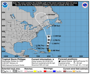
Tropical Storm Philippe
1696424538830.png


000
WTNT42 KNHC 040849
TCDAT2

Tropical Storm Philippe Discussion Number 44
NWS National Hurricane Center Miami FL AL172023
500 AM AST Wed Oct 04 2023

Philippe remains a disorganized tropical storm this morning, yet
continues to produce heavy rainfall over the British and U.S. Virgin
Islands. This activity remains displaced well to the southeast of
the estimated circulation center, and appears to be more associated
with the storm's inflow interacting with a well-defined mid-level
circulation just north of St. Thomas, which is evident from radar in
Puerto Rico. Scatterometer data received just after the last
advisory showed values around 40 kt in this area of convection, and
the initial intensity will be held at 40 kt. This value is on the
higher end of the Dvorak intensity estimates, but does match the
most recent UW-CIMSS SATCON intensity estimate.

The earlier scatterometer data suggested that Philippe had slowed
down some, possibly due to the ongoing convection to its southeast,
but its latest motion appears to have resumed a more northwestward
motion at 325/8 kt. The track guidance remains in agreement about
the storm turning more northward later today, with gradual
acceleration as the mid-level ridge that has been impeding its
poleward progress gradually shifts eastward, and Philippe becomes
steered between a deep-layer low to its west, and the aforementioned
ridge to its east. Compared to the previous cycle, the guidance has
shifted a bit eastward over the first 2-3 days of the forecast
period, and the latest NHC track forecast was shifted a bit further
east early on, but not as far as the consensus aids. After Philippe
passes by Bermuda on Friday, it is forecast to interact with a much
more amplified trough swinging into the northeastern United States
this weekend. This evolution may result in Philippe's track
potentially bending back north-northwest on Saturday, approaching
Atlantic Canada and New England as it phases with the larger trough.
There still remains quite a bit of spread in the track guidance by
96 h due to this interaction.

The intensity forecast remains murky. Right now, the low-level
circulation of Philippe remains diffuse, and even though vertical
wind shear could potentially slacken some over the next 24 hours,
the cyclone appears to be in no state to intensify in the
short-term. Thereafter, Philippe may have an opportunity to take
advantage of some synoptic mid-latitude dynamics associated with the
initial upper-level trough positioned to the west of its
circulation. Thus, some gradual intensification is shown between
36-60 h. With that said, some of the model guidance (like the most
recent GFS run) shows Philippe instead being absorbed into this
non-tropical feature, though that solution is not shown at this
time. Regardless, increasing baroclinicity should also begin to
initiate extratropical transition after 48 hours, which is forecast
to be fully complete sometime in the 72-96 h forecast time frame.
The latest NHC intensity forecast remains near the middle of the
guidance envelope, and is also close to the HFIP Corrected
Consensus Approach (HCCA).

KEY MESSAGES:

1. Heavy rainfall from Philippe is expected to produce scattered
flash flooding across portions of the United States & British Virgin
Islands through today.

2. Gusty winds are likely to continue across portions of the
northern Leeward Islands and the Virgin Islands through early today.

3. The risk is increasing for tropical storm conditions to occur on
Bermuda late this week. Interests on Bermuda should monitor the
progress of Philippe, and Tropical Storm Watches could become
required for the island later today.


FORECAST POSITIONS AND MAX WINDS

INIT 04/0900Z 20.5N 65.5W 40 KT 45 MPH
12H 04/1800Z 21.4N 65.8W 40 KT 45 MPH
24H 05/0600Z 23.3N 66.0W 40 KT 45 MPH
36H 05/1800Z 26.0N 66.0W 45 KT 50 MPH
48H 06/0600Z 29.0N 65.5W 45 KT 50 MPH
60H 06/1800Z 32.0N 65.0W 50 KT 60 MPH
72H 07/0600Z 35.3N 65.1W 50 KT 60 MPH
96H 08/0600Z 43.1N 66.5W 50 KT 60 MPH...POST-TROP/EXTRATROP
120H 09/0600Z 51.5N 72.0W 30 KT 35 MPH...POST-TROP/EXTRATROP

$$
Forecaster Papin
 
Be a part of the community Get 3 HCA Results
Top