shape
carat
color
clarity

You want storms? We have storms.

Arcadian

Ideal_Rock
Premium
Joined
Sep 17, 2008
Messages
9,105
Hurricane Hilary
Cali, y'all better watch this one There's a lot of storms in the Pacific, with additional TS Greg and Fernanda closer to Hawaii. (no direct hits from those storms thankfully)


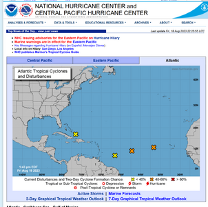
Atlantic side, we've got storms to watch. Next week maybe? GFS says one thing, Euro says another. At current just some orange x's to watch though.
 

kenny

Super_Ideal_Rock
Premium
Joined
Apr 30, 2005
Messages
33,391
EEK :eek2:

Thanks for the heads up.
 

Arcadian

Ideal_Rock
Premium
Joined
Sep 17, 2008
Messages
9,105
I need to get my propane gas tank filled before chaos/panic sets in!:roll2:

Yeah its my plan tomorrow. The bad is that right now we have really no idea the direction. I've seen a couple one coming up through cuba and the keys and going up the SE coast. Another coming across Bahamas and upper FL peninsula though SC

I've seen 2 model runs that say MAYBE August 25 for SE US. But nothing set in stone yet. No air recon at this time either. So we wait.

I do worry about SoCal tho because these storms are a rare occurrence for them, and not like those houses are built with hurricanes in mind, and where that center comes ashore is what will make the difference between SoCal getting a nothing burger or a whole lot of something.

Euro is calling for a weaker storm (a TS) into SoCal but still it will be a wet messy thing.

Either way, its not a tiny storm. The SW will get some rain from it but I think they need it.

At current, Sunday (8/20) into Monday(8/21) is the current time frame. That might change but anyone in the SW should be paying attention and should start preparing for whatever is coming.

I saw something weird on the GFS model run but it could just be an anomaly. I'll know by next model run if it was just a blip or not.
 

Arcadian

Ideal_Rock
Premium
Joined
Sep 17, 2008
Messages
9,105
If it makes sense I can split this thread, I prefer not to...lol I can have admin change the thread title however so that people can find it readily if needed. Let me know.


I'm not used to doing stuff for the left coast so forgive me because there's a bit of time difference in when they issue things


Hurricane Hilary is a cat 4.
...HILARY REMAINS A POWERFUL CATEGORY 4 HURRICANE... ...HURRICANE WARNING ISSUED FOR PORTIONS OF BAJA CALIFORNIA AND TROPICAL STORM WATCH ISSUED FOR EXTREME SOUTHERN CALIFORNIA...

000
WTPZ34 KNHC 181450
TCPEP4

BULLETIN
Hurricane Hilary Advisory Number 9
NWS National Hurricane Center Miami FL EP092023
900 AM MDT Fri Aug 18 2023

...HILARY REMAINS A POWERFUL CATEGORY 4 HURRICANE...
...HURRICANE WARNING ISSUED FOR PORTIONS OF BAJA CALIFORNIA AND
TROPICAL STORM WATCH ISSUED FOR EXTREME SOUTHERN CALIFORNIA...


SUMMARY OF 900 AM MDT...1500 UTC...INFORMATION
----------------------------------------------
LOCATION...17.9N 111.4W
ABOUT 65 MI...110 KM SSW OF SOCORRO ISLAND
ABOUT 360 MI...575 KM SSW OF CABO SAN LUCAS MEXICO
MAXIMUM SUSTAINED WINDS...145 MPH...230 KM/H
PRESENT MOVEMENT...NW OR 305 DEGREES AT 10 MPH...17 KM/H
MINIMUM CENTRAL PRESSURE...939 MB...27.73 INCHES


WATCHES AND WARNINGS
--------------------
CHANGES WITH THIS ADVISORY:

The Government of Mexico has issued a Hurricane Warning for the
Baja California peninsula from Punta Abreojos to Punta Eugenia.

The Government of Mexico has issued a Hurricane Watch for the Baja
California peninsula from north of Punta Eugenia to Ensenada.

The Government of Mexico has issued a Tropical Storm Watch for
mainland Mexico from Bahia Kino northward and from Loreto northward
and from north of Ensenada to the California/Mexico border.

A Tropical Storm Watch is in effect from the California/Mexico
border to the Orange/Los Angeles County Line and for Catalina
Island.

SUMMARY OF WATCHES AND WARNINGS IN EFFECT:

A Hurricane Warning is in effect for...
* Baja California peninsula from Punta Abreojos to Punta Eugenia

A Hurricane Watch is in effect for...
* Baja California peninsula north of Punta Eugenia to Ensenada

A Tropical Storm Warning is in effect for...
* Baja California peninsula from Punta Abreojos southward
* Baja California peninsula from Loreto southward

A Tropical Storm Watch is in effect for...
* Baja California peninsula north of Loreto
* Mainland Mexico north of Huatabampito
* Baja California north of Ensenada to the California/Mexico border
* California/Mexico border to the Orange/Los Angeles County Line
* Catalina Island

A Hurricane Warning means that hurricane conditions are expected
somewhere within the warning area. A warning is typically issued
36 hours before the anticipated first occurrence of
tropical-storm-force winds, conditions that make outside
preparations difficult or dangerous. Preparations to protect life
and property should be rushed to completion.

A Hurricane Watch means that hurricane conditions are possible
within the watch area. A watch is typically issued 48 hours
before the anticipated first occurrence of tropical-storm-force
winds, conditions that make outside preparations difficult or
dangerous.

A Tropical Storm Warning means that tropical storm conditions are
expected somewhere within the warning area within 36 hours.

A Tropical Storm Watch means that tropical storm conditions are
possible within the watch area, generally within 48 hours.

Interests in the southwestern U.S. should monitor the progress of
Hilary.

For storm information specific to your area, please monitor
products issued by your national meteorological service.


DISCUSSION AND OUTLOOK
----------------------
At 900 AM MDT (1500 UTC), the eye of Hurricane Hilary was located
near latitude 17.9 North, longitude 111.4 West. Hilary is moving
toward the northwest near 10 mph (17 km/h). A turn toward the
north-northwest is expected today and tonight, followed by a
faster motion toward the north Saturday night and Sunday. On the
forecast track, the center of Hilary will move close to the west
coast of the Baja California peninsula over the weekend and reach
southern California by Sunday night.

Maximum sustained winds remain near 145 mph (230 km/h) with higher
gusts. Hilary is a category 4 hurricane on the Saffir-Simpson
Hurricane Wind Scale. Fluctuations in intensity are likely over the
next day or so. Weakening is expected to begin by Saturday, but
Hilary will still be a hurricane when it approaches the west coast
of the Baja California peninsula Saturday night and Sunday. Hilary
is expected to weaken to a tropical storm by Sunday afternoon before
it reaches southern California.


Hurricane-force winds extend outward up to 45 miles (75 km) from the
center and tropical-storm-force winds extend outward up to 290 miles
(465 km).

The estimated minimum central pressure is 939 mb (27.73 inches).


HAZARDS AFFECTING LAND
----------------------
Key messages for Hilary can be found in the Tropical Cyclone
Discussion under AWIPS header MIATCDEP4 and WMO header WTPZ44 KNHC
and on the web at hurricanes.gov/text/MIATCDEP4.shtml.

RAINFALL: Hilary is expected to produce rainfall amounts of 3 to 6
inches, with isolated maximum amounts up to 10 inches, across
portions of the Baja California Peninsula through Sunday night.
Flash flooding, locally significant, will be possible.


Heavy rainfall in association with Hilary is expected to impact the
Southwestern United States through next Wednesday, peaking on Sunday
and Monday. Rainfall amounts of 3 to 6 inches, with isolated amounts
of 10 inches, are expected across portions of southern California
and southern Nevada. Rare and dangerous flooding will be possible.
Elsewhere across portions of the Western United States, rainfall
totals of 1 to 3 inches are expected.

WIND: Hurricane conditions are expected within the hurricane
warning area Saturday night and are possible within the hurricane
watch by early Sunday. Tropical storm conditions are expected
within the warning area by late today, and are possible within the
watch area in Mexico on Saturday and in southern California
beginning Sunday.

STORM SURGE: A dangerous storm surge is likely to produce coastal
flooding along the western Baja California peninsula of Mexico near
where the center passes the coast in areas of onshore winds, or
east of the center if Hilary makes landfall. The surge will be
accompanied by large and destructive waves.

SURF: Large swells generated by Hilary will affect portions of the
coast of southwestern Mexico and the Baja California peninsula over
the next few days. These swells are likely to cause
life-threatening surf and rip current conditions. Please consult
products from your local weather office.


NEXT ADVISORY
-------------
Next intermediate advisory at 1200 PM MDT.
Next complete advisory at 300 PM MDT.

$$
Forecaster Cangialosi

I have to update my machine because its being absolutely crazy until I do so (thank you Micro$oft.) So no screen shots for now. I will do that in the next post.
 

tyty333

Super_Ideal_Rock
Premium
Joined
Dec 17, 2008
Messages
27,361
I dont mind it in one thread but may be helpful to put something like "East Cost" or "West Coast" at the top of each
post so we know what you are targeting in that post. I think it's helpful to keep separate posts for each side of the U.S
(vs. having it all in one post).

But, you can set it up in what works best for you @Arcadian since this is a PSA and you're doing all the work! (Again, thank you!)
 

Arcadian

Ideal_Rock
Premium
Joined
Sep 17, 2008
Messages
9,105
I honestly don't mind it. I'm looking at it anyway so I may as well give everybody a heads up if I can. I will ask this this is renamed to hurricane hilary and make a new one for the SE because its gotten very interesting.
 

autumngems

Ideal_Rock
Premium
Joined
Jul 24, 2003
Messages
2,603
Living in the East coast NC, this is never good, I am watching. Florence did a number on us here.
 

Arcadian

Ideal_Rock
Premium
Joined
Sep 17, 2008
Messages
9,105
Lot of uncertain stuff in the atlantic


atlantic.PNG

And model guidance has changed some.

Also theres now air recon data for Hilary
For those who are super curious: https://www.tropicaltidbits.com/recon/


Speaking of, Hilary is still a cat 4.

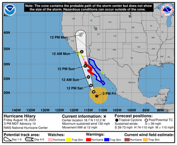
204813_5day_cone_no_line_and_wind.png
There was some expectation of weakening but man...I don't know. Seems to be taking its time. Something crazy drastic will need to happen to really weaken it at this point, so its more or less wait and see. Model guidance says it will weaken, but it said it would before now and it hasn't so......

Just know that the winds/rain will be felt well outside of wherever that center is.

The cone is only where they think the center will be, not the size of the storm. The actual wind field is what needs to be paid attention to (the yellow /brown boxes) and this indicates a quite large wind field.


702
WTPZ44 KNHC 182046
TCDEP4

Hurricane Hilary Discussion Number 10
NWS National Hurricane Center Miami FL EP092023
300 PM MDT Fri Aug 18 2023

Hilary remains a large and powerful major hurricane. The Air Force
Hurricane Hunters sampled the northern portion of Hilary and found a
higher minimum pressure than expected of 948 mb, 700 mb flight-level
winds of 113 kt, and peak SFMR surface winds of 93 kt. However, the
aircraft did not sample the southern half of the circulation, which
currently has some of the deepest convection. Blending the available
aircraft data and latest satellite intensity estimates yields an
initial intensity of 115 kt.


Hilary continues to slowly bend to the right, and the initial motion
is northwestward or 315/10 kt. A general north-northwest to north
motion with a steady increase in forward speed is expected tonight
and through the weekend as the system is steered by pronounced
steering flow between a strong subtropical ridge over the
south-central U.S. and a mid- to upper-level low off the central
California coast. The models have trended faster this cycle, and
the NHC forecast has followed suit. Based on the latest forecast,
the core of Hilary is expected to be very near the central portion
of Baja California Saturday night and move inland over southern
California by Sunday night. It should be noted that strong winds and
heavy rains will occur well ahead of the center.


Fluctuations in the hurricane's strength are expected through
tonight, but Hilary is expected to begin weakening on Saturday as it
moves over progressively cooler SSTs and into an environment of
increasing shear and drier air. The NHC intensity forecast is lower
than the previous one, partially due to the lower initial intensity,
and a little higher than the HCCA and IVCN models.


KEY MESSAGES:

1. Heavy rainfall associated with Hilary will begin well in advance
of the center, from the Baja California Peninsula into the
Southwestern United States. Preparations for the impacts of flooding
from rainfall should be completed as soon as possible, as heavy rain
will increase ahead of the center on Saturday. In the Southwestern
United States, flash, urban, and arroyo flooding is expected, with
the potential for dangerous and locally catastrophic impacts.

2. Hurricane conditions are expected within portions of the
hurricane warning area along the west-central coast of the Baja
California Peninsula Saturday night and are possible in the
Hurricane Watch area.

3. Tropical storm conditions are possible by late Sunday in
portions of southern California where a Tropical Storm Watch is in
effect.

4. Large swells generated by Hilary will affect portions of the
coast of southwestern Mexico, the Baja California peninsula, and
south California over the next few days. These swells are likely
to cause life-threatening surf and rip current conditions.


FORECAST POSITIONS AND MAX WINDS

INIT 18/2100Z 18.7N 112.2W 115 KT 130 MPH
12H 19/0600Z 20.3N 113.2W 115 KT 130 MPH
24H 19/1800Z 22.6N 114.1W 105 KT 120 MPH
36H 20/0600Z 25.6N 115.0W 85 KT 100 MPH
48H 20/1800Z 29.4N 116.1W 65 KT 75 MPH
60H 21/0600Z 34.1N 117.3W 45 KT 50 MPH...INLAND
72H 21/1800Z 39.3N 117.7W 30 KT 35 MPH...POST-TROP/INLAND
96H 22/1800Z...DISSIPATED

$$
Forecaster Cangialosi
 

Arcadian

Ideal_Rock
Premium
Joined
Sep 17, 2008
Messages
9,105
Certainly I hope no one needs any supplies but always good to have JIC. Also no need to go absolutely crazy (some do) and if one has a propane grill, things like cans of soup or dried beans, 5 gallons of extra water (heck your water heater tank doubles as usable water) and a small bug out bag if there's a need to move to a better location, then all should be fine.

I try to post so at least people who are here have some idea can prepare without scrambling, but also to just be aware of things.

On the SE coast there's no model agreement. At least one of those 4 x's will develope into something, maybe 2 by one model run. However, we know that a generalized low can cause all types of damage even without any designation (its happened before). Texas should much needed rain out of one of these.


And even though NHC uses blended models Sometimes the folks on the news rely strictly on GFS, which has been a major suck the last few years as its been kinda wrong when it counted.

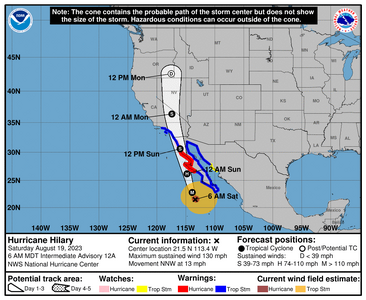
115409_5day_cone_no_line_and_wind.png


936
WTPZ34 KNHC 191154
TCPEP4

BULLETIN
Hurricane Hilary Intermediate Advisory Number 12A
NWS National Hurricane Center Miami FL EP092023
600 AM MDT Sat Aug 19 2023

...CATASTROPHIC AND LIFE-THREATENING FLOODING LIKELY OVER BAJA
CALIFORNIA AND THE SOUTHWESTERN U.S. THROUGH MONDAY...
...HURRICANE-FORCE WINDS EXPECTED ALONG THE WEST-CENTRAL COAST OF
THE BAJA CALIFORNIA PENINSULA TONIGHT AND SUNDAY MORNING...


SUMMARY OF 600 AM MDT...1200 UTC...INFORMATION
----------------------------------------------
LOCATION...21.5N 113.4W
ABOUT 240 MI...390 KM WSW OF THE SOUTHERN TIP OF BAJA CALIFORNIA
ABOUT 490 MI...790 KM SSE OF PUNTA EUGENIA MEXICO
MAXIMUM SUSTAINED WINDS...130 MPH...215 KM/H
PRESENT MOVEMENT...NNW OR 335 DEGREES AT 13 MPH...20 KM/H
MINIMUM CENTRAL PRESSURE...943 MB...27.85 INCHES


WATCHES AND WARNINGS
--------------------
CHANGES WITH THIS ADVISORY:

None.

SUMMARY OF WATCHES AND WARNINGS IN EFFECT:

A Hurricane Warning is in effect for...
* Baja California peninsula from Punta Abreojos to Cabo San Quintin

A Hurricane Watch is in effect for...
* Baja California peninsula north of Cabo San Quintin to Ensenada

A Tropical Storm Warning is in effect for...
* Baja California peninsula from Punta Abreojos southward
* Baja California peninsula entire east coast
* Baja California peninsula north of Cabo San Quintin to the
California/Mexico border
* Mainland Mexico north of Guaymas
* California/Mexico border to Point Mugu
* Catalina Island

A Tropical Storm Watch is in effect for...
* Mainland Mexico from Huatabampito to Guaymas

A Hurricane Warning means that hurricane conditions are expected
somewhere within the warning area. A warning is typically issued
36 hours before the anticipated first occurrence of
tropical-storm-force winds, conditions that make outside
preparations difficult or dangerous. Preparations to protect life
and property should be rushed to completion.

A Hurricane Watch means that hurricane conditions are possible
within the watch area. A watch is typically issued 48 hours
before the anticipated first occurrence of tropical-storm-force
winds, conditions that make outside preparations difficult or
dangerous.

A Tropical Storm Warning means that tropical storm conditions are
expected somewhere within the warning area within 36 hours.

A Tropical Storm Watch means that tropical storm conditions are
possible within the watch area, generally within 48 hours.

Interests elsewhere in the southwestern U.S. should monitor the
progress of Hilary.

For storm information specific to your area in the United
States, including possible inland watches and warnings, please
monitor products issued by your local National Weather Service
forecast office. For storm information specific to your area
outside of the United States, please monitor products issued by
your national meteorological service.


DISCUSSION AND OUTLOOK
----------------------
At 600 AM MDT (1200 UTC), the center of Hurricane Hilary was located
near latitude 21.5 North, longitude 113.4 West. Hilary is moving
toward the north-northwest near 13 mph (20 km/h).
A faster motion
toward the north-northwest is expected to begin later today,
followed by an even faster motion toward the north by Sunday night.
On the forecast track, the center of Hilary will move close to the
west-central coast of the Baja California peninsula tonight and on
Sunday and move across southern California Sunday afternoon and
Sunday night.

Maximum sustained winds are near 130 mph (215 km/h) with higher
gusts. Hilary is a category 4 hurricane on the Saffir-Simpson
Hurricane Wind Scale. Weakening is expected to begin today, but
Hilary will still be a hurricane when it approaches the west coast
of the Baja California peninsula tonight and Sunday morning. Hilary
is expected to weaken to a tropical storm by midday Sunday before it
reaches southern California.

Hurricane-force winds extend outward up to 50 miles (85 km) from
the center and tropical-storm-force winds extend outward up to 265
miles (425 km). A sustained wind of 46 mph (74 km/h) and a gust to
62 mph (100 km/h) were recently reported at the Cabo San Lucas
Marina.

The minimum central pressure is estimated to be 943 mb (27.85
inches).


HAZARDS AFFECTING LAND
----------------------
Key messages for Hilary can be found in the Tropical Cyclone
Discussion under AWIPS header MIATCDEP4 and WMO header WTPZ44 KNHC
and on the web at hurricanes.gov/text/MIATCDEP4.shtml.

RAINFALL: Hilary is expected to produce rainfall amounts of 3 to 6
inches, with isolated maximum amounts up to 10 inches, across
portions of the Baja California Peninsula through Sunday night.
Flash and urban flooding, locally catastrophic, will be likely,
especially in the northern portions of the peninsula.

Heavy rainfall in association with Hilary is expected across the
Southwestern United States, peaking on Sunday, and possibly lasting
through Monday. Rainfall amounts of 3 to 6 inches, with isolated
amounts of 10 inches, are expected across portions of southern
California and southern Nevada. Dangerous to locally catastrophic
flooding will be likely. Elsewhere across portions of the Western
United States, rainfall totals of 1 to 3 inches are expected,
resulting in localized flash flooding.

WIND: Hurricane conditions are expected within the hurricane
warning area tonight and early Sunday and are possible within the
hurricane watch on Sunday. Tropical storm conditions are occurring
within the southern portion of the tropical storm warning area and
will spread northward today and Sunday. Tropical storm conditions
are possible within the tropical storm watch area today and tonight.
Tropical storm conditions are expected to begin in southern
California on Sunday.

Winds could be particularly strong and gusty in and near areas of
higher terrain.

STORM SURGE: A dangerous storm surge is likely to produce coastal
flooding along the western Baja California peninsula of Mexico near
where the center passes the coast in areas of onshore winds, or
east of the center if Hilary makes landfall. The surge will be
accompanied by large and destructive waves.

TORNADOES: A tornado or two may occur Sunday over parts of the
lower Colorado River Valley, Mojave Desert and Imperial Valley
regions.

SURF: Large swells generated by Hilary will affect portions of the
coast of southwestern Mexico, the Baja California peninsula, and
southern California over the next few days. These swells are likely
to cause life-threatening surf and rip current conditions. Please
consult products from your local weather office.


NEXT ADVISORY
-------------
Next complete advisory at 900 AM MDT.

$$
Forecaster Cangialosi
 

Arcadian

Ideal_Rock
Premium
Joined
Sep 17, 2008
Messages
9,105

missy

Super_Ideal_Rock
Premium
Joined
Jun 8, 2008
Messages
54,265
A poem by Mary Oliver


"

Hurricane

It didn't behave

like anything you had

ever imagined. The wind

tore at the trees, the rain

fell for days slant and hard.

The back of the hand

to everything. I watched

the trees bow and their leaves fall

and crawl back into the earth.

As though, that was that.

This was one hurricane

I lived through, the other one

was of a different sort, and

lasted longer. Then

I felt my own leaves giving up and

falling. The back of the hand to

everything. But listen now to what happened

to the actual trees;

toward the end of that summer they

pushed new leaves from their stubbed limbs.

It was the wrong season, yes,

but they couldn't stop. They

looked like telephone poles and didn't

care. And after the leaves came

blossoms. For some things

there are no wrong seasons.

Which is what I dream of for me.

-- Mary Oliver, A Thousand Mornings

"


Stay safe everyone.
 

Arcadian

Ideal_Rock
Premium
Joined
Sep 17, 2008
Messages
9,105
Hope that everyone in SW is doing well this morning. There's some action happening.


Hilary is a TS thankfully. At this point its going to be all live so you guys please stay safe, be careful, pay attention to whats going on out there. The rainfall may not sound like a lot (for where I am its not) but its a lot for that area in short amounts of time, so landslides, flash floods are a possibility.

The good is that the storm is moving fast, so it will not linger for days on end.

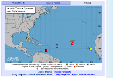
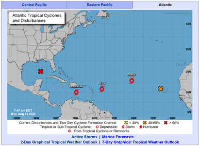
On to the Atlantic....I don't even know whats going on here...lol a freaking party? Today we have rain. We've had lots of rain lately and its probably coming from that yellow X.
atlantic8-20-2023.PNG

Also, Emily has formed.
 

Matata

Ideal_Rock
Premium
Joined
Sep 10, 2003
Messages
9,084
Heavy rain and flash flood potential in LA and a 5.0 earthquake. Double whammy by Mutha Nature.
 

missy

Super_Ideal_Rock
Premium
Joined
Jun 8, 2008
Messages
54,265
What's next? A plague??
(Oh wait we had that already ::) )
 

Arcadian

Ideal_Rock
Premium
Joined
Sep 17, 2008
Messages
9,105

tyty333

Super_Ideal_Rock
Premium
Joined
Dec 17, 2008
Messages
27,361
My DH prefers it like the above (one after another) because he says it continues to eat up the energy with smaller storms. Hope I didn't
just jinx us and hope his theory is correct! Its a little more daunting for me to see one storm right after another knowing that anyone
could turn into a hurricane.:oops2:
 

Arcadian

Ideal_Rock
Premium
Joined
Sep 17, 2008
Messages
9,105
My DH prefers it like the above (one after another) because he says it continues to eat up the energy with smaller storms. Hope I didn't
just jinx us and hope his theory is correct! Its a little more daunting for me to see one storm right after another knowing that anyone
could turn into a hurricane.:oops2:

Usually, yes but the water is very very hot, these storms are not really reaching deep enough to churn up the cold water just yet. Certainly I'm hoping for some big ones that will!!

The worrisome part is we're approaching the most active part of the season.
 

Matata

Ideal_Rock
Premium
Joined
Sep 10, 2003
Messages
9,084

Arcadian

Ideal_Rock
Premium
Joined
Sep 17, 2008
Messages
9,105
Some updates:
08-21-2023-2.PNG

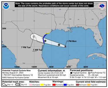
175815_5day_cone_no_line_and_wind.png Nine is a low level Tropical storm and only because it won't have a lot of room to be bigge/stronger. Still, it only takes 1 so Texas knows the drill on these. Water is plenty warm. It will gain a name soon.


000
WTNT44 KNHC 211440
TCDAT4

Potential Tropical Cyclone Nine Discussion Number 1
NWS National Hurricane Center Miami FL AL092023
1000 AM CDT Mon Aug 21 2023

The broad area of low pressure over the central Gulf of Mexico
continues to gradually become better organized with showers and
thunderstorms increasing on the system's north side. However,
surface observations and early morning visible satellite images
suggest that it does not have a well-defined center yet, and
therefore, does not meet the definition of a tropical cyclone at
this time. Since the system is forecast to strengthen and make
landfall as a tropical storm on Tuesday, advisories are being
initiated on Potential Tropical Cyclone Nine with Tropical Storm
Warnings now in effect for portions of south Texas.

The disturbance is moving fairly quickly to the west at 14 kt on the
south side of a strong mid-level ridge located over the central U.S.
An even faster motion to the west or west-northwest is expected,
taking the system over southern Texas by midday Tuesday. It should
be noted that since the system does not yet have a clear center, the
details of the track forecast are a bit uncertain. The Air Force
Hurricane Hunters are scheduled to investigate the system this
afternoon, which should help assess the low-level structure.

The environmental factors are generally favorable for the system to
strengthen. However, there is limited time for the disturbance to
take advantage of those conditions, especially since it still lacks
a well-defined center. The NHC official intensity forecast shows
the system reaching a peak intensity of 40 kt before landfall, which
is near the high end of the model guidance. Rapid weakening is
expected after landfall.

KEY MESSAGES:

1. Heavy rainfall from Potential Tropical Cyclone Nine is expected
across South Texas on Tuesday and Wednesday. The heavy rainfall may
produce areas of flash and urban flooding. Across portions of
Coahilla and Nuevo Leon in Mexico, flash flooding with possible
landslides in mountainous terrain is expected Tuesday into
Wednesday.

2. Coastal flooding is possible along the south Texas coast
tonight through Tuesday morning.

3. Tropical storm conditions are expected in the warning area and
are possible in the watch area beginning Tuesday morning.

FORECAST POSITIONS AND MAX WINDS

INIT 21/1500Z 25.0N 89.9W 25 KT 30 MPH...POTENTIAL TROP CYCLONE
12H 22/0000Z 25.5N 92.8W 30 KT 35 MPH...TROPICAL CYCLONE
24H 22/1200Z 26.6N 96.8W 40 KT 45 MPH
36H 23/0000Z 27.8N 100.1W 25 KT 30 MPH...POST-TROP/REMNT LOW
48H 23/1200Z...DISSIPATED

$$
Forecaster Cangialosi

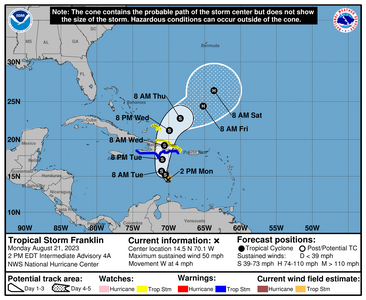
Franklin will be hitting mostly Puerto Rico, DR/Haiti Bermuda may not be out of the question. Should be watched because they're saying it will be a hurricane after it hits these islands.
175635_5day_cone_no_line_and_wind.png

000
WTNT43 KNHC 211445
TCDAT3

Tropical Storm Franklin Discussion Number 4
NWS National Hurricane Center Miami FL AL082023
1100 AM EDT Mon Aug 21 2023

There are no lack of cold cloud tops associated with Tropical Storm
Franklin this morning. The structure on satellite consists of a
large bursting pattern, with cloud tops as cold as -90C close to and
just east of the estimated center. However, it is unclear if any of
this deep convection has resulted in structural improvement to
the storm, with the most recent microwave imagery from a SSMIS F-16
pass at 1007 UTC showing a chaotic structure, with evidence the
center remains near the western edge of this large convective
shield. The latest subjective satellite intensity estimates form
TAFB is unchanged from earlier this morning. Thus, the initial
intensity will remain 45 kt this advisory, which is also close to
the latest D-MINT and D-PRINT estimates from UW-CIMSS.

Franklin does appear to be slowing down a tad this morning while
moving westward, with the latest estimate at 270/5 kt. The track
forecast in the short-term is a bit problematic, with a large spread
in model solutions even at 12 h, much higher than the climatological
spread. This initial uncertainty may be related intensity
differences in the global models, with some of the stronger guidance
suggesting the tropical cyclone might reform further to the north
and east over the next 12-24 hours. Thereafter, a large weakness to
the north of Franklin, produced by a large mid-ocean trough draped
across the Western Atlantic, should allow the storm to begin moving
northward. A mid-latitude trough reinforces this weakness to the
north in 60-72h, allowing the storm to begin moving northeastward.
The most significant change in the guidance this cycle is the
majority are quite a bit slower than the prior cycle, and the NHC
forecast track was slowed down a bit, but not as much as some of the
consensus aids.

Currently, Franklin is experiencing some moderate 15-20 kt westerly
shear, which has paused its intensification for the time being.
However, this shear is forecast to gradual decrease as it begins to
move more northward, providing an opportunity for the tropical storm
to strengthen as it approaches Hispaniola. Some weakening appears
likely once the system moves over Hispaniola, especially if the
storm moves over the highest terrain in the Dominican Republic. By
Thursday, Franklin should be back over open waters in the Atlantic
Ocean and has an opportunity to start strengthening again. However,
the environment does not appear to be especially pristine, with the
ECMWF showing more southwesterly vertical wind shear than the GFS.
For now, its assumed this shear will not prevent slow
intensification, possibly because the storm should be moving in the
same direction as the shear vector, and the NHC intensity forecast
will still show Franklin becoming a hurricane towards the end of the
forecast period. This forecast is in best agreement with the HFIP
corrected consensus approach (HCCA) but remains lower than some of
the more aggressive regional-hurricane models (COAMPS-TC, HWRF).


KEY MESSAGES:

1. Heavy rainfall from Franklin is expected across portions of
Puerto Rico and Hispaniola through the middle of the week. The
heavy rainfall may produce areas of flash and urban flooding as well
as river rises and mudslides. Across Hispaniola, significant and
potentially life-threatening flash flooding is possible Tuesday into
Wednesday.

2. Franklin is expected to bring tropical storm conditions to
portions of the Dominican Republic and Haiti beginning on Tuesday
where Tropical Storm Warnings are in effect.


FORECAST POSITIONS AND MAX WINDS

INIT 21/1500Z 15.0N 70.1W 45 KT 50 MPH
12H 22/0000Z 15.2N 70.5W 45 KT 50 MPH
24H 22/1200Z 15.7N 71.0W 50 KT 60 MPH
36H 23/0000Z 17.3N 70.9W 55 KT 65 MPH
48H 23/1200Z 19.2N 70.6W 45 KT 50 MPH...INLAND
60H 24/0000Z 21.2N 69.9W 45 KT 50 MPH...OVER WATER
72H 24/1200Z 22.8N 68.4W 55 KT 65 MPH
96H 25/1200Z 24.4N 65.2W 65 KT 75 MPH
120H 26/1200Z 26.4N 63.7W 75 KT 85 MPH

$$
Forecaster Papin


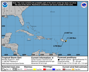
Gert has no juice
145250_5day_cone_no_line_and_wind.png
711
WTNT41 KNHC 211451
TCDAT1

Tropical Storm Gert Discussion Number 9
NWS National Hurricane Center Miami FL AL062023
1100 AM AST Mon Aug 21 2023

Gert barely qualifies a tropical cyclone. Visible satellite imagery
indicates it still has a well-enough defined circulation sustained
by a small area of deep convection that is displaced east of Gert's
surface center. That said, during the few hours since sunrise, the
tropical storm's circulation appears to have become stretched as
convection has waned. The initial intensity estimate is 35 kt based
on recent satellite estimates and ASCAT data last night, but new
ASCAT data is expected very soon that will provide better
information about the current maximum winds.

Strong upper-level winds associated with an upper-level low to the
north of Gert and outflow from the more robust Franklin to its west
ought to prevent Gert's convection from getting better organized.
Most dynamical models continue to indicate that Gert will open into
a trough within the next 12-36 h. While the tiny tropical cyclone
has been quite persistent thus far, its hard to envision Gert
lasting much longer in its current environment. Although the NHC
forecast maintains Gert for a little longer, it could realistically
dissipate at any time.

The initial motion of the tropical cyclone remains westward at a
slightly slower forward pace than overnight. Gert (or its remnants)
will likely turn west-northwestward or northwestward by tonight
until dissipation occurs. The NHC track forecast is very close to
the various consensus aids.


FORECAST POSITIONS AND MAX WINDS

INIT 21/1500Z 16.9N 57.0W 35 KT 40 MPH
12H 22/0000Z 17.2N 58.0W 30 KT 35 MPH...POST-TROP/REMNT LOW
24H 22/1200Z 17.8N 59.1W 30 KT 35 MPH...POST-TROP/REMNT LOW
36H 23/0000Z...POST-TROP/REMNT LOW

$$
Forecaster D. Zelinsky


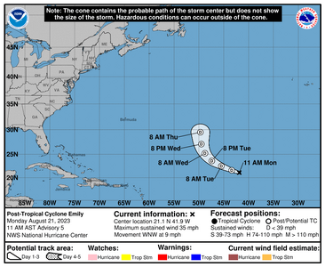
Emily is already post tropical and no real land threats
143141_5day_cone_no_line_and_wind.png


842
WTNT42 KNHC 211430
TCDAT2

Post-Tropical Cyclone Emily Discussion Number 5
NWS National Hurricane Center Miami FL AL072023
1100 AM AST Mon Aug 21 2023

Emily has been devoid of deep convection for nearly 15 hours and no
longer meets the definition of a tropical cyclone. Although sea
surface temperatures are sufficiently warm to support occasional
bursts of convection, strong wind shear and a very dry environment
should prevent it from re-organizing as a tropical cyclone for at
least the next couple days. The initial intensity of 30 kt is based
on ASCAT-B data valid at 1200 UTC.

In about 3 days, the remnant low is forecast to turn northward as it
encounters a deep-layer trough over the central Atlantic. While it
turns, Emily could briefly encounter a more favorable upper-level
wind pattern, which could support the redevelopment of convection.
However, the low-level center may also become stretched and
ill-defined at the same time. Regeneration as a tropical cyclone
does not appear likely enough to explicitly forecast it at this
time. Information on the potential for regeneration will be included
in future Tropical Weather Outlooks, if necessary. Future
information on Emily can also be found in High Seas forecasts issued
by the National Hurricane Center and Ocean Prediction Center.


FORECAST POSITIONS AND MAX WINDS

INIT 21/1500Z 21.1N 41.9W 30 KT 35 MPH...POST-TROP/REMNT LOW
12H 22/0000Z 21.6N 43.4W 30 KT 35 MPH...POST-TROP/REMNT LOW
24H 22/1200Z 22.5N 45.5W 30 KT 35 MPH...POST-TROP/REMNT LOW
36H 23/0000Z 23.6N 47.4W 30 KT 35 MPH...POST-TROP/REMNT LOW
48H 23/1200Z 25.2N 48.8W 30 KT 35 MPH...POST-TROP/REMNT LOW
60H 24/0000Z 27.1N 49.5W 30 KT 35 MPH...POST-TROP/REMNT LOW
72H 24/1200Z 29.5N 49.7W 30 KT 35 MPH...POST-TROP/REMNT LOW
96H 25/1200Z...DISSIPATED

$$
Forecaster D. Zelinsky


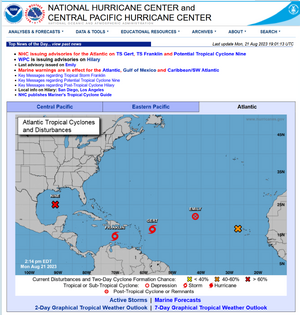
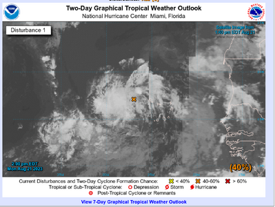
Our last orange X.... hmmmm
x2.PNG
ZCZC MIATWOAT ALL
TTAA00 KNHC DDHHMM

Tropical Weather Outlook
NWS National Hurricane Center Miami FL
200 PM EDT Mon Aug 21 2023

For the North Atlantic...Caribbean Sea and the Gulf of Mexico:

Active Systems:
The National Hurricane Center is issuing advisories on Tropical
Storm Franklin, located over the east-central Caribbean Sea, on
Tropical Storm Gert, located several hundred miles east-southeast
of the northern Leeward Islands, and has issued the last advisory
on Post-Tropical Cyclone Emily, located over the central Atlantic.

The National Hurricane Center is issuing advisories on
Potential Tropical Cyclone Nine, located over the central Gulf
of Mexico.
* Formation chance through 48 hours...high...90 percent.
* Formation chance through 7 days...high...90 percent.

1. Eastern Tropical Atlantic (AL92):
Showers and thunderstorms over portions of the tropical eastern
Atlantic are associated with a tropical wave. Environmental
conditions appear generally conducive for gradual development of
this system, and a tropical depression is likely to form later this
week while it moves west-northwestward across the eastern tropical
Atlantic.
* Formation chance through 48 hours...medium...40 percent.
* Formation chance through 7 days...high...70 percent.

Public Advisories on Tropical Storm Franklin are issued under WMO
header WTNT33 KNHC and under AWIPS header MIATCPAT3.
Forecast/Advisories on Tropical Storm Franklin are issued under WMO
header WTNT23 KNHC and under AWIPS header MIATCMAT3.

Public Advisories on Potential Tropical Cyclone Nine are issued
under WMO header WTNT34 KNHC and under AWIPS header MIATCPAT4.
Forecast/Advisories on Potential Tropical Cyclone Nine are issued
under WMO header WTNT24 KNHC and under AWIPS header MIATCMAT4.

Forecaster Cangialosi/Papin
 

Attachments

  • 175635.png
    175635.png
    61.7 KB · Views: 0

canuk-gal

Super_Ideal_Rock
Premium
Joined
Apr 19, 2004
Messages
25,833
HI:

Ran into my neighbour who has property in Palm Desert. She showed me a video of the river and debris that is in her golf course......not pretty! Stay safe people!!!

cheers--Sharon
 

Arcadian

Ideal_Rock
Premium
Joined
Sep 17, 2008
Messages
9,105
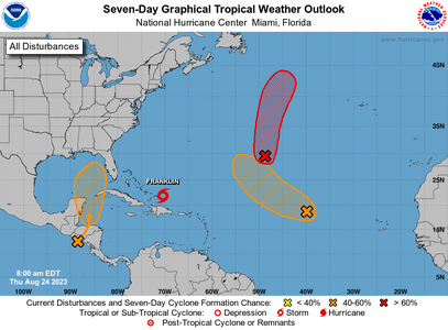
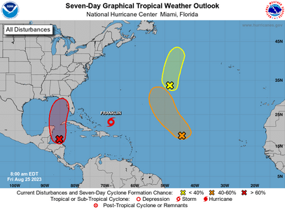
I will post this in a new thread but we have a spot that will it FL as a high level TS or a LL hurricane. Either way a named storm is coming out of this it seems.

I'm seeing 2 very interesting model runs that are predicting this. GFS has no agreement just yet (might tho) and NHC has put a spot on the map for it.

Timeframe is August 29-31 possible. will keep y'all informed.
two_atl_7d0.png
 

Arcadian

Ideal_Rock
Premium
Joined
Sep 17, 2008
Messages
9,105
There's model agreement that FL will have a cat 1 or a tropical storm next week. Pay close attention to the red x, it will be the next named storm, which will likely be an I.
two_atl_7d0.png
Its going to sit between BOC and Cuba for a few days because there won't be any steering currents. The water temps there are well above normal which will cause it to grow. In the meantime, Franklin will become a hurricane , get big enough to pull the storm up though the Florida peninsula and track close to the SE cost (likely gonna be an I named storm). Still on track to possibly hit Tuesday/Wednesday on the SW Central coast of FL but could hit lower, one never knows with these things.

Y'all in FL, prepare if you haven't already. East coast, we're on the dirty side, you know what that means.

Lets all hope for a nothing burger. I hate I named storms.

Once this storm is named I will create a separate thread.
 

Arcadian

Ideal_Rock
Premium
Joined
Sep 17, 2008
Messages
9,105
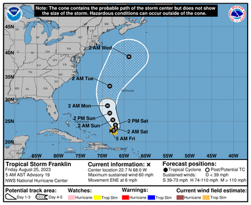
Canadians, you have not been forgotten this year!

Franklin is coming for a visit.
084425_5day_cone_no_line_and_wind.png
This storm is currently kinda meandering and gaining strength. watch out for it.


000
WTNT43 KNHC 250841
TCDAT3

Tropical Storm Franklin Discussion Number 19
NWS National Hurricane Center Miami FL AL082023
500 AM AST Fri Aug 25 2023

Franklin has generally changed little during the past several hours.
The storm remains strongly sheared with the low-level center
partially exposed near the western edge of the main area of deep
convection. Cloud tops are quite cold on the system's east side,
but the storm continues to lack convective symmetry. The initial
intensity remains 50 kt based on the earlier Air Force
reconnaissance data, which is a little above the current satellite
intensity estimates.

The storm is moving slowly to the east-northeast at about 5 kt in
weak steering currents near the base of a broad mid- to upper-level
trough. A north to north-northwest motion is expected to commence
tonight or early Saturday as ridging builds to the east of Franklin
over the central Atlantic. This motion should bring the core of the
system to the west of Bermuda on Monday and Tuesday. The storm is
likely to turn northeastward and accelerate by the middle of next
week when it should move in the faster flow between the ridge and a
mid- to upper-level trough over eastern Canada and the northeast
U.S. In general, the models have shifted westward this cycle, and
the NHC track forecast has been nudged in that direction.

Continued moderate to strong westerly vertical wind shear should
limit strengthening during the next 12 to 24 hours. However, more
significant strengthening seems likely in a day or two when the
shear decreases while Franklin remains over warm water and in a
relatively moist environment. Franklin is expected to become a
hurricane over the weekend and should reach a peak intensity near
major hurricane strength early next week. The strengthening trend
should end around day 4, at which time the storm is forecast to
begin moving over cooler waters and into an environment of stronger
shear. The intensity models are in fairly good agreement, and this
forecast is quite similar to the previous one.


FORECAST POSITIONS AND MAX WINDS

INIT 25/0900Z 22.7N 68.0W 50 KT 60 MPH
12H 25/1800Z 22.8N 67.4W 50 KT 60 MPH
24H 26/0600Z 23.3N 66.9W 55 KT 65 MPH
36H 26/1800Z 24.1N 67.0W 60 KT 70 MPH
48H 27/0600Z 25.3N 67.6W 65 KT 75 MPH
60H 27/1800Z 26.9N 68.3W 80 KT 90 MPH
72H 28/0600Z 28.6N 68.8W 90 KT 105 MPH
96H 29/0600Z 33.0N 68.3W 95 KT 110 MPH
120H 30/0600Z 39.2N 63.9W 85 KT 100 MPH

$$
Forecaster Cangialosi
 

Arcadian

Ideal_Rock
Premium
Joined
Sep 17, 2008
Messages
9,105
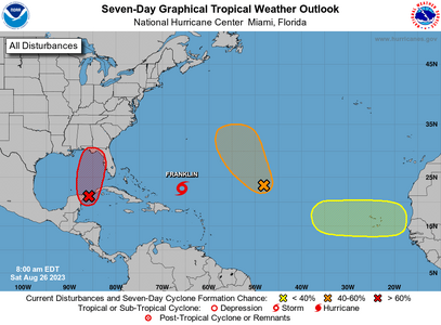
OK y'all here we go again, this looks like its going to be an I named storm

two_atl_7d10.png


ZCZC MIATWOAT ALL
TTAA00 KNHC DDHHMM

Tropical Weather Outlook
NWS National Hurricane Center Miami FL
800 AM EDT Sat Aug 26 2023

For the North Atlantic...Caribbean Sea and the Gulf of Mexico:

Active Systems:
The National Hurricane Center is issuing advisories on Tropical
Storm Franklin, located several hundred miles south of Bermuda.

1. Northwestern Caribbean Sea and Eastern Gulf of Mexico (AL93):
Shower and thunderstorm activity continues to show signs of
organization in association with an area of low pressure located
near the Yucatan Channel. Environmental conditions appear conducive
for further development of this system, and a tropical depression is
likely to form within the next day or two while it moves generally
northward over the southeastern Gulf of Mexico. Interests in the
Yucatan Peninsula of Mexico, western Cuba, and Florida should
monitor the progress of this system.
* Formation chance through 48 hours...high...70 percent.
* Formation chance through 7 days...high...90 percent.
 

Arcadian

Ideal_Rock
Premium
Joined
Sep 17, 2008
Messages
9,105
Florida, Alabama, Georgia, NC and SC be on watch of this storm. FL, we need to be preparing, especially anyone on the west coast, panhandle, and Jacksonville area.
 

diamondringlover

Ideal_Rock
Premium
Joined
Dec 12, 2006
Messages
4,415
argggghhh been watching this we are heading to SC tomorrow and going to be there till Friday........
 

Arcadian

Ideal_Rock
Premium
Joined
Sep 17, 2008
Messages
9,105
argggghhh been watching this we are heading to SC tomorrow and going to be there till Friday........

Well this is going to be the next storm. NHC has it at 90% so, they'll call it either tonight or early tomorrow as Idalia. Its super organized right now and just sitting there getting bigger :confused2:
 
Be a part of the community Get 3 HCA Results
Top