shape
carat
color
clarity

Watching Storm Larry in the Atlantic

Arcadian

Ideal_Rock
Premium
Joined
Sep 17, 2008
Messages
9,091
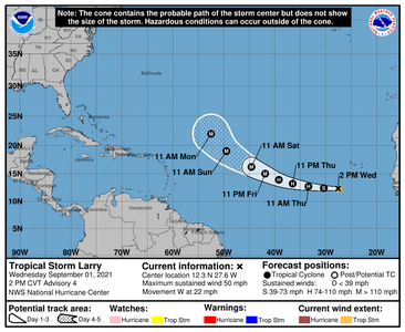
This is a storm that will , if the track holds, pass by Bermuda but has some potential of hitting CONUS depending weather conditions.
I wouldn't call it alarming, but models are hinting at something. I'm not experienced to know what, but I think more experienced meteorologists are just keeping an eye on it, especially after Ida.

this weekend will give more insight on the track for next week.
145205_5day_cone_no_line_and_wind.png
 

PinkAndBlueBling

Brilliant_Rock
Premium
Joined
Dec 16, 2017
Messages
1,681
Oh my gosh! This is a crazy season! Isn't it early to already be on an "L" storm, or is this typical?
 

foxinsox

Ideal_Rock
Premium
Joined
Jul 18, 2015
Messages
4,066
OH MY! I was in a call with some people in the US an hour ago and their emergency alerts were going off like nuts - is this storm hitting the US already? I hope you're all safe
 

Arcadian

Ideal_Rock
Premium
Joined
Sep 17, 2008
Messages
9,091
OH MY! I was in a call with some people in the US an hour ago and their emergency alerts were going off like nuts - is this storm hitting the US already? I hope you're all safe

Depends on where you were calling. Parts of the northeast is getting hit with remnants of Ida which is causing all kinds of havoc. Some places in Pennsylvania had to evacuate because of flooding.
 

Lookinagain

Ideal_Rock
Premium
Joined
May 15, 2014
Messages
4,532
no, Larry isn't here yet. But parts of the North East U.S. are getting all the rains from Ida and there are flash floods in some places. Maybe the emergency alerts were about those? I'm in New England and we've been warned that there may be flash floods and the amount of rain I'm getting right now makes me think it is possible.
 

Arcadian

Ideal_Rock
Premium
Joined
Sep 17, 2008
Messages
9,091
Oh my gosh! This is a crazy season! Isn't it early to already be on an "L" storm, or is this typical?

Last season we got to Zeta Iota in the greek alphabet. https://en.wikipedia.org/wiki/2020_Atlantic_hurricane_season

Definitely they predicted this year to be as bad as last year for named storms though they're ditching the greek names and using the "alternate list". The good is that many of these storms don't end up being major hurricanes. The bad is the ones that do.
 

Arcadian

Ideal_Rock
Premium
Joined
Sep 17, 2008
Messages
9,091
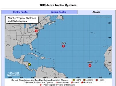
These are the current active storms for the Atlantic Basin There's even more for the Pacific!! They usually go out to sea but every once in a while, some will go into land. Arizona just got a soaker that was a pretty decent sized hurricane before it hit Mexico. Its very rare for both oceans to be active at the same time though Its usually one or the other. Right now its nearing peak season in the Atlantic Basin so we've got lots of activity.

In the Atlantic Ida and Kate are post tropical. Larry is now I believe a hurricane, which is why it needs to be watched as it could be a major one, and, that little X down by Belize is something to watch because every once in a while, a model takes it into Texas or Louisiana as a hurricane. Not enough agreement on it to be a thread yet.
9-1-2021Active_Atlantic_Storms.JPG
 

Mayk

Ideal_Rock
Premium
Joined
Feb 12, 2011
Messages
4,773
Fish Storm! I hope!
 

foxinsox

Ideal_Rock
Premium
Joined
Jul 18, 2015
Messages
4,066
Depends on where you were calling. Parts of the northeast is getting hit with remnants of Ida which is causing all kinds of havoc. Some places in Pennsylvania had to evacuate because of flooding.
That’s where they were - so it was a different terrible storm with Larry still on the way? That’s awful.
 

Arcadian

Ideal_Rock
Premium
Joined
Sep 17, 2008
Messages
9,091
That’s where they were - so it was a different terrible storm with Larry still on the way? That’s awful.

Yep. that storm is parts of Ida, the same storm that decimated Louisiana and parts of Mississippi.

Larry is a very big storm with potential to do damage depending on where the highs end up.

Many years ago it was explained to me by using a pinball machine...lol but I do like leaf analogy much more.

Think of a hurricane like a leaf, and the highs as an object in the water that push the leaf one way or another. A leaf can't move on its own in the water, it needs something to move it along.

A strong hurricane, say something in the 950-930 millibar range can actually move a high aside if its not strong enough. Hurricanes in that range are usually quite big though.

Hurricanes want to go to the magnetic north, they'll take whatever path they can to get there though the highs.

So the highs are very important and their placement is important because they're the steering currants for storms. Without them, storms wouldn't move. Hurricane Dorian is a classic example where it sat over the Bahamas for 5 days at a Cat 5.
 

tyty333

Super_Ideal_Rock
Premium
Joined
Dec 17, 2008
Messages
27,270
Oh no...hoping for a northward path that keeps it off the coast!:pray:

You are quite knowledgeable about the mechanics @Arcadian !
 

foxinsox

Ideal_Rock
Premium
Joined
Jul 18, 2015
Messages
4,066
Yep. that storm is parts of Ida, the same storm that decimated Louisiana and parts of Mississippi.

Larry is a very big storm with potential to do damage depending on where the highs end up.

Many years ago it was explained to me by using a pinball machine...lol but I do like leaf analogy much more.

Think of a hurricane like a leaf, and the highs as an object in the water that push the leaf one way or another. A leaf can't move on its own in the water, it needs something to move it along.

A strong hurricane, say something in the 950-930 millibar range can actually move a high aside if its not strong enough. Hurricanes in that range are usually quite big though.

Hurricanes want to go to the magnetic north, they'll take whatever path they can to get there though the highs.

So the highs are very important and their placement is important because they're the steering currants for storms. Without them, storms wouldn't move. Hurricane Dorian is a classic example where it sat over the Bahamas for 5 days at a Cat 5.
Fingers crossed for the right conditions for it to not land. We don’t get hurricanes so I’ve never known much about them. Thank you for the explanation.
 

Arcadian

Ideal_Rock
Premium
Joined
Sep 17, 2008
Messages
9,091
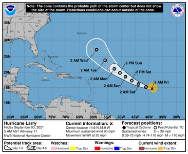
Larry is now a rather large hurricane and moving WNW at 20MPH. thats a fast moving storm! Its supposed to sweep Bermuda next week.

083516_5day_cone_no_line_and_wind.png
 

Arcadian

Ideal_Rock
Premium
Joined
Sep 17, 2008
Messages
9,091
So far Larry is staying the course but as noted by NHC there could be an eyewall replacement happening. In general when that happens the storm can get weaker but it can also get bigger and rebuild itself back up. Next week is next week to see where it heads.
 

missy

Super_Ideal_Rock
Premium
Joined
Jun 8, 2008
Messages
54,163
Off topic a bit and I hope you don't mind @Arcadian. I have a question.

Greg and I and some similarly weather obsessed friends have noticed, at least locally, our meteorologists forecasts have been off by quite a bit in the past year or so. As in rain predicted the next day (less than 24 hours prediction when you would expect some accuracy at least) and there is no rain at all. And vice versa. I am not talking about a week in advance rather a day or less away and their predictions are inaccurate. Happens more often than not this past year. Locally at least.


Now, one could say, being by the water, local weather patterns have a mind of their own. But again, in years past, this inaccuracy has not been as pronounced as it is now. There has definitely been a change towards forecasts being completely wrong. Not just a little bit wrong but polar opposite wrong.

Have you noticed a similar pattern and if so what do you think is happening?
This has been a topic of discussion with us and our friends and we are wondering what is happening.

Thanks.
 

Arcadian

Ideal_Rock
Premium
Joined
Sep 17, 2008
Messages
9,091
Off topic a bit and I hope you don't mind @Arcadian. I have a question.

Greg and I and some similarly weather obsessed friends have noticed, at least locally, our meteorologists forecasts have been off by quite a bit in the past year or so. As in rain predicted the next day (less than 24 hours prediction when you would expect some accuracy at least) and there is no rain at all. And vice versa. I am not talking about a week in advance rather a day or less away and their predictions are inaccurate. Happens more often than not this past year. Locally at least.


Now, one could say, being by the water, local weather patterns have a mind of their own. But again, in years past, this inaccuracy has not been as pronounced as it is now. There has definitely been a change towards forecasts being completely wrong. Not just a little bit wrong but polar opposite wrong.

Have you noticed a similar pattern and if so what do you think is happening?
This has been a topic of discussion with us and our friends and we are wondering what is happening.

Thanks.

I think its this:

Its not really a could change but IS changing. The forecast models we use today don't always keep up with that.

Being able to properly forecast weather really relies heavily on those currents and thats what helps drive weather everywhere, including onto or off of large land masses. The computer models use lots of previous years data to help as do satellites, but if its wrong...well, you can get a wrong forecast.

Your local guys use the same thing as all the internet guys do, it all comes from the same place. But yeah they can be wrong too. Being wrong at times has some bad consequences.

However I think that also comes the fact that if they were wrong, and wrong several times in a row, that when there's real danger coming, people will not pay attention to it, and its kind of a weird pendulum swing. I don't always fault local forecasters because they have a fine line to walk. But I also learned ages ago to do my own research...lol.

I'm pretty sure that some in the NE didn't think Ida would come that way because they don't like to forecast anything bad past 5 days (lots can change in that time) And some choose to use a very small subset of models to forecast because thats what they're comfortable with, and maybe they honestly didn't see it (everyone does not use the models the way they should)

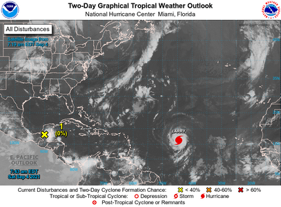
Honestly, I'm not only looking at Larry, but that small mass of storms coming across near the BOC because its a known hotspot. Also you don't see it here but there's storms currently coming off Africa that some models are suggesting could turn into something later.
t3wo_atl_2d0.png
 

josieKat

Shiny_Rock
Joined
May 13, 2018
Messages
187
I found this true for Western New York. My wife plows most winters so we keep an constant eye on the snow forecast - now, lake effect is always tricky, but the last few years the forecasts have just been seriously off for non-lake effect events (predicting 4-6" but getting none, predicting a dusting and getting slammed).
 

missy

Super_Ideal_Rock
Premium
Joined
Jun 8, 2008
Messages
54,163
I think its this:

Its not really a could change but IS changing. The forecast models we use today don't always keep up with that.

Being able to properly forecast weather really relies heavily on those currents and thats what helps drive weather everywhere, including onto or off of large land masses. The computer models use lots of previous years data to help as do satellites, but if its wrong...well, you can get a wrong forecast.

Your local guys use the same thing as all the internet guys do, it all comes from the same place. But yeah they can be wrong too. Being wrong at times has some bad consequences.

However I think that also comes the fact that if they were wrong, and wrong several times in a row, that when there's real danger coming, people will not pay attention to it, and its kind of a weird pendulum swing. I don't always fault local forecasters because they have a fine line to walk. But I also learned ages ago to do my own research...lol.

I'm pretty sure that some in the NE didn't think Ida would come that way because they don't like to forecast anything bad past 5 days (lots can change in that time) And some choose to use a very small subset of models to forecast because thats what they're comfortable with, and maybe they honestly didn't see it (everyone does not use the models the way they should)

Honestly, I'm not only looking at Larry, but that small mass of storms coming across near the BOC because its a known hotspot. Also you don't see it here but there's storms currently coming off Africa that some models are suggesting could turn into something later.
t3wo_atl_2d0.png

Thanks @Arcadian it's all very interesting and complex. We were bracing here despite the forecast not being too terrible. We were fortunate but so many were not.


"
Hurricane Ida’s path of destruction exposed a harsh climate reality: The U.S. is not prepared for extreme weather.​
Nearly a week after the storm made landfall in Louisiana, roughly 70 percent of energy customers in New Orleans remain without power. Cleanup crews are working to contain what experts called a substantial oil spill Ida left in the Gulf of Mexico. In New York City, 13 people died, many of whom drowned in basement apartments. The storm killed at least 25 people in New Jersey — more than in any other state.​
As disasters become more severe, the cost of rebuilding has skyrocketed. Extreme weather has caused more than $450 billion in damage nationwide since 2005; the number of disasters causing more than $1 billion in damage reached a record 22 last year. The price tags mean the U.S. faces another climate dilemma: how to decide which places to try to save.​
After a summer of fires and storms, President Biden and progressive Democrats are using the moment to push for aggressive climate provisions in a sweeping $3.5 trillion budget bill.​

"
 

Arcadian

Ideal_Rock
Premium
Joined
Sep 17, 2008
Messages
9,091
Larry is still poised to be near Bermuda next week. The size of it will mean that they'll get a little something out of it.

522
WTNT42 KNHC 051445
TCDAT2

Hurricane Larry Discussion Number 20
NWS National Hurricane Center Miami FL AL122021
1100 AM AST Sun Sep 05 2021

Larry continues as a large and intense hurricane this morning, with
a 40 n mi diameter eye surround by cloud tops to near -80 deg C.
There are, however, some breaks in the cold tops over the northern
portion of the circulation. The current intensity is adjusted
slightly to 110 kt, based on a blend of subjective Dvorak estimates
from TAFB and SAB along with objective ADT estimates from UW-CIMSS.
Upper-level outflow remains somewhat restricted over the
southwestern quadrant of the system, indicative of at least slight
vertical shear. This shear is probably being caused by the flow to
the east of an upper-level low to the north of Puerto Rico. The low
is forecast to move northwestward over the next few days, possibly
lessening the shear over Larry.

The hurricane is moving northwestward at a slightly slower speed, or
310/11 kt. Larry is likely to continue its northwestward trek
along the southwestern periphery of a mid-tropospheric anticyclone
during the next 2-3 days, with only a slight reduction in forward
speed. Around 96 hours, the hurricane is forecast to turn toward
the north-northwest and north while rounding the western side of
the ridge. By the end of the forecast period, Larry is expected to
begin its recurvature into the mid-latitude westerlies. The new
official forecast track essentially follows the previous one, and is
also very close to the latest NOAA corrected consensus and Florida
State University Superensemble guidance.

Larry's large eye suggests that no rapid changes in strength are
likely during the short term. Since vertical shear is not expected
to increase and the system will be traversing warm waters, the
hurricane should be able to more or less maintain its intensity
during the next few days. One inhibiting factor is the presence of
relatively dry mid-level air in the environment. The official
intensity forecast is on the high side of the model guidance and
keeps Larry as a major hurricane through 72 hours.


Key Messages:

1. Large swells generated by Larry are expected to reach the Lesser
Antilles today and will spread to portions of the Greater Antilles,
the Bahamas, and Bermuda on Monday and Tuesday. Significant swells
will likely reach the east coast of the United States and Atlantic
Canada by midweek. These swells will likely cause life-threatening
surf and rip current conditions, and beachgoers and other interests
along these coasts are urged to follow the advice of lifeguards and
local officials this week.

2. Larry is forecast to approach Bermuda during the next several
days, likely as a major hurricane, bringing a risk of strong
winds, heavy rainfall, and coastal flooding to the island by the
middle of this week. While it is too soon to determine the
magnitude of these hazards and potential impacts on Bermuda,
interests there should closely monitor the latest forecast updates
during the next several days.


FORECAST POSITIONS AND MAX WINDS

INIT 05/1500Z 19.5N 49.7W 110 KT 125 MPH
12H 06/0000Z 20.5N 51.1W 110 KT 125 MPH
24H 06/1200Z 21.9N 52.7W 110 KT 125 MPH
36H 07/0000Z 23.0N 54.0W 110 KT 125 MPH
48H 07/1200Z 24.3N 55.4W 105 KT 120 MPH
60H 08/0000Z 25.7N 56.7W 105 KT 120 MPH
72H 08/1200Z 27.3N 58.1W 105 KT 120 MPH
96H 09/1200Z 31.1N 61.1W 95 KT 110 MPH
120H 10/1200Z 37.4N 60.6W 85 KT 100 MPH

$$
Forecaster Pasch
 

Arcadian

Ideal_Rock
Premium
Joined
Sep 17, 2008
Messages
9,091
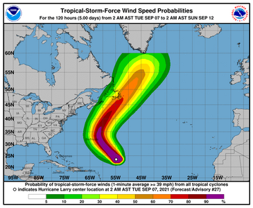
Larry is really quite large with a big eye meaning that as it passes by Bermuda it could well do some damage. Don't discount the wave action on the East coast of the US either, lots of riptide warnings from this storm.


000
WTNT42 KNHC 070848
TCDAT2

Hurricane Larry Discussion Number 27
NWS National Hurricane Center Miami FL AL122021
500 AM AST Tue Sep 07 2021

Larry has maintained a very warm, pronounced eye with a diameter of
around 45 to 50 n mi overnight. However, recent infrared satellite
imagery and earlier microwave data show some weaknesses in the
western eyewall of the hurricane, potentially signaling the
entrainment of some drier air into its inner core. This could be the
result of some moderate westerly shear impinging on the system. The
initial intensity is lowered to 105 kt for this advisory, based on a
0520 UTC SATCON estimate of 103 kt and T5.5/102 kt current intensity
Dvorak estimates from TAFB and SAB. An Air Force Reserve hurricane
hunter reconnaissance flight is scheduled to investigate Larry later
this morning, which should provide more insight into the hurricane's
structure and intensity.

Larry is moving toward the northwest at 315/9 kt, as the hurricane
is being steered around a subtropical ridge over the central
Atlantic. This general motion is expected to continue for the next
48 h or so. By Thursday, the hurricane is forecast to turn northward
within the flow between the ridge and an approaching deep-layer
trough that will be crossing the northeastern United States. As the
trough moves over the western Atlantic, Larry should accelerate
northeastward deeper into the mid-latitudes on Friday and Saturday,
passing near or over portions of Atlantic Canada. The latest NHC
track forecast lies near the HCCA and TVCA consensus aids, and no
significant adjustments were made from the previous forecast. Larry
is expected to pass east of Bermuda on Thursday as a large
hurricane. Given the expansive size of its wind field, a Tropical
Storm Watch could be required for the island later today.

Although the warm sea-surface temperatures and diminishing vertical
wind shear along Larry's forecast track appear favorable during the
next couple of days, it may not be able to take advantage of these
conditions due to its large size, as well as the potential for
another eyewall replacement cycle. As previously noted, Larry's
broad wind field and moderate forward speed could also result in
some upwelling of cooler waters near its inner core. There remains a
split in the intensity guidance, with the statistical-dynamical
guidance notably higher than the coupled atmosphere-ocean models.
The official NHC intensity forecast shows a gradual weakening of
Larry during the next several days. Nonetheless, Larry will remain a
forceful hurricane that continues to produce significant swell with
far-reaching impacts through the week. After 72 h, Larry should
begin its extratropical transition, and the official forecast shows
Larry becoming a hurricane-force extratropical cyclone by 96 h.


Key Messages:

1. Large swells generated by Larry will continue to affect the
Lesser Antilles, portions of the Greater Antilles, and the Bahamas
through midweek. Significant swells should reach the east coast of
the United States and Atlantic Canada by midweek and continue
affecting these shores through the end of the week. These swells
will likely cause life-threatening surf and rip current conditions,
and beachgoers and other interests along these coasts are urged to
follow the guidance of lifeguards and local officials this week.


2. Larry is forecast to approach Bermuda during the next couple of
days as a large and powerful hurricane, bringing a risk of strong
winds, heavy rainfall, and coastal flooding to the island by
Thursday. Tropical storm watches could be needed for the island
later today, and interests in Bermuda should closely monitor the
latest forecast updates.


FORECAST POSITIONS AND MAX WINDS

INIT 07/0900Z 23.8N 55.1W 105 KT 120 MPH
12H 07/1800Z 24.9N 56.0W 100 KT 115 MPH
24H 08/0600Z 26.5N 57.4W 95 KT 110 MPH
36H 08/1800Z 28.4N 59.1W 95 KT 110 MPH
48H 09/0600Z 30.6N 60.8W 95 KT 110 MPH
60H 09/1800Z 33.3N 61.8W 90 KT 105 MPH
72H 10/0600Z 37.1N 61.0W 85 KT 100 MPH
96H 11/0600Z 47.7N 52.4W 75 KT 85 MPH...POST-TROP/EXTRATROP
120H 12/0600Z 57.0N 43.0W 55 KT 65 MPH...POST-TROP/EXTRATROP

$$
Forecaster Reinhart
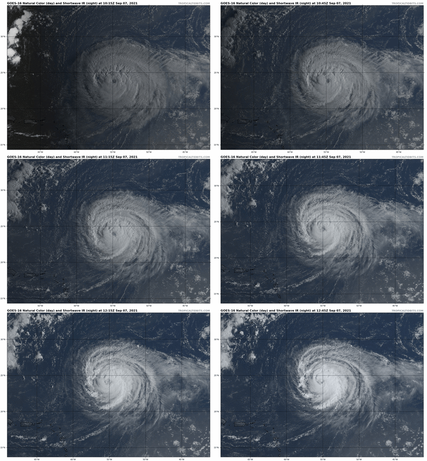
085124.png

goes16_truecolor_12L_202109071015.gif
 

Arcadian

Ideal_Rock
Premium
Joined
Sep 17, 2008
Messages
9,091
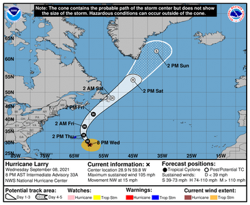
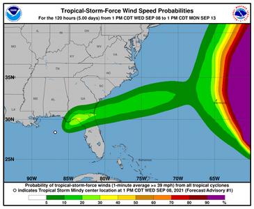
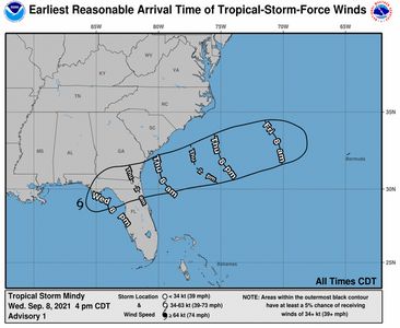
While watching Larry, today about 4pm today Mindy formed. Mindy will stay a low level Tropical Storm and follow Larry However Mindy formed in the Gulf and will go over the panhandle part of Georgia tonight into tomorrow.

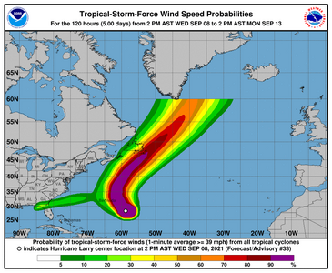
Larry is enormous with an extremely large eye and windfield. Bermuda will feel some of it, thankfully they're on the east of the storm. We've got some pretty nasty rip currents where I am. 235243_5day_cone_no_line_and_wind.png
235243.png

234103.png

234103_earliest_reasonable_toa_no_wsp_34.png
 

Arcadian

Ideal_Rock
Premium
Joined
Sep 17, 2008
Messages
9,091
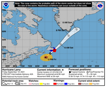
Canadians, y'all are about to get a visit from Larry. Amazed its been a hurricane this long!

175212_5day_cone_no_line_and_wind.png

000
WTNT42 KNHC 101448
TCDAT2

Hurricane Larry Discussion Number 40
NWS National Hurricane Center Miami FL AL122021
1100 AM AST Fri Sep 10 2021

Larry remains a well organized hurricane at a high latitude, and it
is quickly approaching southeastern Newfoundland. Satellite images
show a fairly tight inner core and large curved bands surrounding
that feature. However, there are some notable dry slots between the
core and bands that have developed during the past several hours.
The latest Dvorak numbers have nudged downward, with the CI values
ranging between 65 kt and 72 kt. Based on these estimates, and a
very recent ASCAT pass that showed peak winds near 65 kt, the
initial intensity is set at 70 kt for this advisory. The cyclone
remains quite large, with hurricane-force winds and
tropical-storm-force winds estimated to extend outward up to 80 and
210 n mi from the center, respectively.

The hurricane is in the process of turning to the right, with the
latest initial motion estimated to be a fairly quick 015/25 kt. An
even faster north-northeast to northeast motion is expected during
the next day or two as the hurricane moves in the fast flow between
a mid- to upper-level trough over the northeastern U.S./eastern
Canada and a mid-level ridge over the central Atlantic. This motion
should take Larry across southeastern Newfoundland tonight. Larry
is then expected to merge with a large extratropical low over the
Labrador Sea on Sunday. The NHC track forecast is similar to the
previous one and near the middle of the guidance envelope.

Although Larry will be moving over cooler waters north of the Gulf
Stream Current later today, the hurricane will likely hold its
strength or weaken just a little before landfall. After landfall,
the models show the inner core dissipating, and the combination of
land interaction, cooler waters, and an increase in shear should
cause weakening and lead to extratropical transition by early
Saturday. The NHC intensity forecast is close to the GFS model,
which often performs well for hurricanes that transition to
extratropical cyclones.


Key Messages:

1. Larry is forecast to move over portions of southeastern
Newfoundland tonight as it undergoes transition to a
hurricane-force post-tropical cyclone. Hurricane conditions, a
dangerous storm surge, and heavy rainfall are expected in portions
of southeastern Newfoundland where a Hurricane Warning in effect.

2. Large swells generated by Larry will continue to affect the
Bahamas, Bermuda, and the east coast of the United States and
Atlantic Canada through Saturday night. These swells will cause
life-threatening surf and rip current conditions, and beachgoers
and other interests along these coasts are urged to follow the
guidance of lifeguards and local officials.


FORECAST POSITIONS AND MAX WINDS

INIT 10/1500Z 40.0N 60.5W 70 KT 80 MPH
12H 11/0000Z 45.1N 56.4W 70 KT 80 MPH
24H 11/1200Z 52.0N 49.4W 60 KT 70 MPH...POST-TROP/EXTRATROP
36H 12/0000Z 57.5N 44.0W 60 KT 70 MPH...POST-TROP/EXTRATROP
48H 12/1200Z 61.1N 38.7W 55 KT 65 MPH...POST-TROP/EXTRATROP
60H 13/0000Z...DISSIPATED

$$
Forecaster Cangialosi
 
Be a part of the community Get 3 HCA Results
Top