shape
carat
color
clarity

Houston/Gulf/FL Peninsula (Laura and Marco)

Arcadian

Ideal_Rock
Premium
Joined
Sep 17, 2008
Messages
9,105
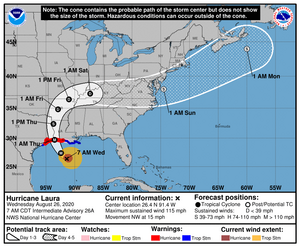
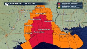
I have stupid meeting at 11am but will post the advisory. Basically though its expected that Galvaston/Houston area will be on the dirty side of the storm based on some projections.

they're at least updating this area.
 

whitewave

Super_Ideal_Rock
Premium
Joined
Feb 29, 2012
Messages
12,330
We may not even get anything from Laura at this point.

She looks like she could be a monster though, so Houston, be ready!
 

tyty333

Super_Ideal_Rock
Premium
Joined
Dec 17, 2008
Messages
27,346
Oh no, Cat 3...boo hiss! We (and I mean my DH) would have to be putting up the storm shutters.

I'm hoping the weather broadcasters are wrong and it only makes it to a 2 at most. Fingers crossed for you guys!
 

Arcadian

Ideal_Rock
Premium
Joined
Sep 17, 2008
Messages
9,105
New track update at 5pm. I heard tha there are some wobbles here and there which can change the track of the eye but, still big enough storm that those lttle wobbles may not matter much.
 

Arcadian

Ideal_Rock
Premium
Joined
Sep 17, 2008
Messages
9,105
laura091953_5day_cone_no_line_and_wind.png

Laura is now on track to be a cat 4 at landfall. :cry:

It will also continue to be a storm well inland, and, this storm is very wide. will not post any scary pictures but its enormous and well formed. Classic hurricane signature look with a face.

Outside the cone will get hurricane force to tropical storm force winds at landfall, most of the damage of storm surge will be felt on the east side to the mississipi possible alabama border.

Please heed your local evacuations. I'm scared for those having to deal with this!
 

Arcadian

Ideal_Rock
Premium
Joined
Sep 17, 2008
Messages
9,105

Slickk

Ideal_Rock
Premium
Joined
Jan 3, 2013
Messages
5,022
Stay safe all!!!
 

missy

Super_Ideal_Rock
Premium
Joined
Jun 8, 2008
Messages
54,248
Keeping good thoughts for everyone affected. Stay safe!
 

Matata

Ideal_Rock
Premium
Joined
Sep 10, 2003
Messages
9,080

junebug17

Super_Ideal_Rock
Premium
Joined
Jun 17, 2009
Messages
14,154
This is pretty scary, keeping all those affected in my thoughts.
 

Arcadian

Ideal_Rock
Premium
Joined
Sep 17, 2008
Messages
9,105
Pressure down to 948. Flooding happening already. Gonna be a very long night for many.
 
Q

Queenie60

Guest
I'm sorry @Arcadian - sending prayers your way and thank you for checking in. Please let us know that you're okay tomorrow if you can.
 

Arcadian

Ideal_Rock
Premium
Joined
Sep 17, 2008
Messages
9,105
I'm sorry @Arcadian - sending prayers your way and thank you for checking in. Please let us know that you're okay tomorrow if you can.
Florida is fine thankfully, and we got our little taste of Laura already...thankfully only wind!
 

Arcadian

Ideal_Rock
Premium
Joined
Sep 17, 2008
Messages
9,105
...800 PM CDT POSITION UPDATE...
...POSSIBLE TORNADOES OCCURRING IN LAURA'S OUTER BANDS OVER
SOUTHEASTERN LOUISIANA AND EXTREME SOUTHWESTERN MISSISSIPPI...

SUMMARY OF 800 PM CDT...0100 UTC...INFORMATION
----------------------------------------------
LOCATION...28.7N 93.1W
ABOUT 95 MI...155 KM S OF LAKE CHARLES LOUISIANA
ABOUT 95 MI...155 KM SSE OF PORT ARTHUR TEXAS
MAXIMUM SUSTAINED WINDS...150 MPH...240 KM/H
PRESENT MOVEMENT...NNW OR 335 DEGREES AT 15 MPH...24 KM/H
MINIMUM CENTRAL PRESSURE...937 MB...27.67 INCHES


the storm is now on the cusp of a Cat 5 At this point it barely matters if the pressure continues to drop.
 
Be a part of the community Get 3 HCA Results
Top