shape
carat
color
clarity

Storm Beryl

Arcadian

Ideal_Rock
Premium
Joined
Sep 17, 2008
Messages
9,434
Being a gem forum there's something fitting about this name...lol

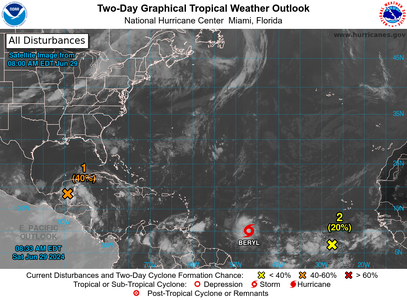
There's a lot going on but will concentrate on Beryl for now.


1719670267967.png
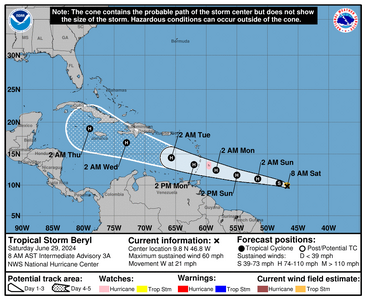
Cone only tells you that this is where the eye of the storm is. Damage happens well outside the cone. This is due to be a hurricane by Sunday.


Current GFS shows that Beryl could have a possible Texas landfall around July 10 but that's over 10 days away and lots can change within that time frame. Thats literally only one model run and no concurrence from any other model. Lots of things can change this far out, heck even 24 hours out things change. Gulf states should be watching no matter what.


1719670463433.png

000
WTNT32 KNHC 291232 CCA
TCPAT2

BULLETIN
Tropical Storm Beryl Intermediate Advisory Number 3A...Corrected
NWS National Hurricane Center Miami FL AL022024
800 AM AST Sat Jun 29 2024

Corrected distance from Barbados

...BERYL STRENGTHENING...
...EXPECTED TO BECOME A HURRICANE BEFORE IT REACHES THE WINDWARD
ISLANDS...


SUMMARY OF 800 AM AST...1200 UTC...INFORMATION
----------------------------------------------
LOCATION...9.8N 46.8W
ABOUT 890 MI...1435 KM ESE OF BARBADOS
MAXIMUM SUSTAINED WINDS...60 MPH...95 KM/H
PRESENT MOVEMENT...W OR 280 DEGREES AT 21 MPH...33 KM/H
MINIMUM CENTRAL PRESSURE...999 MB...29.50 INCHES


WATCHES AND WARNINGS
--------------------
CHANGES WITH THIS ADVISORY:

None

SUMMARY OF WATCHES AND WARNINGS IN EFFECT:

A Hurricane Watch is in effect for...
* Barbados

Interests elsewhere in the Lesser Antilles should closely monitor
the progress of Beryl. Additional watches and warnings will likely
be required for portions of this area later this morning.

For storm information specific to your area, please monitor
products issued by your national meteorological service.


DISCUSSION AND OUTLOOK
----------------------
At 800 AM AST (1200 UTC), the center of Tropical Storm Beryl was
located near latitude 9.8 North, longitude 46.8 West. Beryl is
moving toward the west near 21 mph (33 km/h). A relatively quick
westward to west-northwestward motion is expected during the next
few days. On the forecast track, the system is expected to move
across the Windward Islands late Sunday night and Monday.

Maximum sustained winds have increased to near 60 mph (95 km/h)
with higher gusts. Steady to rapid strengthening is expected during
the next couple of days, and Beryl is forecast to become a
hurricane tonight or early Sunday with additional strengthening
expected after that.

Tropical-storm-force winds extend outward up to 45 miles (75 km)
from the center.

The estimated minimum central pressure is 999 mb (29.50 inches).


HAZARDS AFFECTING LAND
----------------------
Key messages for Tropical Storm Beryl can be found in the
Tropical Cyclone Discussion under AWIPS header MIATCDAT2 and WMO
header WTNT42 KNHC.

WIND: Hurricane conditions are possible in the hurricane watch area
by Sunday night or Monday morning, with tropical storm conditions
possible on Sunday.

STORM SURGE: A dangerous storm surge will raise water levels by
as much as 2 to 4 feet above normal tide levels in areas of
onshore flow in the Hurricane Watch area. Near the coast, the
surge will be accompanied by large and destructive waves.

RAINFALL: Tropical Storm Beryl is expected to produce rainfall
totals of 3 to 6 inches across Barbados and the Windward Islands.
This rainfall may produce localized flooding in vulnerable areas.

For a complete depiction of forecast rainfall and flash flooding
associated with Tropical Storm Beryl, please see the National
Weather Service Storm Total Rainfall Graphic, available at
hurricanes.gov/graphics_at2.shtml?rainqpf and the Flash Flood Risk
graphic at hurricanes.gov/graphics_at2.shtml?ero

SURF: Swells generated by the storm are expected to reach the
Windward and southern Leeward Islands by late Sunday. These swells
are likely to cause life-threatening surf and rip current
conditions. Please consult products from your local weather office.


NEXT ADVISORY
-------------
Next complete advisory at 1100 AM AST.

$$
Forecaster Cangialosi
 
Beryl is now a hurricane. Hurricane hunters are out gathering data

Based on what I know today,this will be a major storm hitting the islands. GFS is still showing a curve into Texas , but things can change and not enough model agreement that far out.


Some runs show a blocking high, others show nothing there. So if the high is in place and its a strong enough high and the storm itself is weaker than a major, it sends the storm into Mexico. If the high is weak, and the storm retains strength, it could certainly get into the gulf and do some kinda crazy stuff.

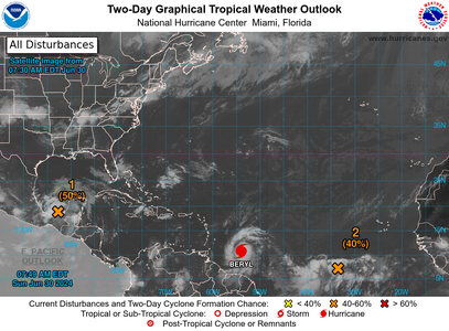
Two-Day Graphical Tropical Weather outlook map that shows 2 disturbances and 1 hurricane

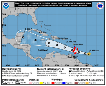
Hurricane Beryl  - Sunday June 30, 2024 Current Information and forcast positions


000
WTNT32 KNHC 301148 CCA
TCPAT2

BULLETIN
Hurricane Beryl Intermediate Advisory Number 7A...Corrected
NWS National Hurricane Center Miami FL AL022024
800 AM AST Sun Jun 30 2024

Corrected maximum sustained winds in Summary

...BERYL IS NOW A VERY DANGEROUS CATEGORY 3 HURRICANE...
...LIFE-THREATENING WINDS AND STORM SURGE EXPECTED IN THE
WINDWARD ISLANDS BEGINNING EARLY MONDAY...


SUMMARY OF 800 AM AST...1200 UTC...INFORMATION
----------------------------------------------
LOCATION...10.6N 53.9W
ABOUT 420 MI...675 KM ESE OF BARBADOS
MAXIMUM SUSTAINED WINDS...115 MPH...185 KM/H
PRESENT MOVEMENT...W OR 280 DEGREES AT 21 MPH...33 KM/H
MINIMUM CENTRAL PRESSURE...968 MB...28.58 INCHES


WATCHES AND WARNINGS
--------------------
CHANGES WITH THIS ADVISORY:

The government of Trinidad has upgraded the Tropical Storm Warning
to a Hurricane Warning for Tobago.

SUMMARY OF WATCHES AND WARNINGS IN EFFECT:

A Hurricane Warning is in effect for...
* Barbados
* St. Lucia
* St. Vincent and the Grenadine Islands
* Grenada
* Tobago

A Tropical Storm Warning is in effect for...
* Martinique

A Tropical Storm Watch is in effect for...
* Dominica

A Hurricane Warning means that hurricane conditions are expected
somewhere within the warning area. Preparations to protect life
and property should be rushed to completion.

A Tropical Storm Warning means that tropical storm conditions are
expected somewhere within the warning area within 36 hours.

A Tropical Storm Watch means that tropical storm conditions are
possible within the watch area, generally within 48 hours.

Interests elsewhere in the Lesser Antilles should closely monitor
the progress of Beryl. Additional watches and warnings may be
required later today.

For storm information specific to your area, please monitor
products issued by your national meteorological service.


DISCUSSION AND OUTLOOK
----------------------
At 800 AM AST (1200 UTC), the eye of Hurricane Beryl was located
near latitude 10.6 North, longitude 53.9 West. Beryl is moving
toward the west near 21 mph (33 km/h). A continued quick westward
to west-northwestward motion is expected during the next few days.
On the forecast track, the center of Beryl is expected to move
across the Windward Islands early on Monday and across the
southeastern Caribbean Sea Monday night and Tuesday.

Aircraft data indicate that the maximum sustained winds have
increased to near 115 mph (185 km/h) with higher gusts, making
Beryl a very dangerous category 3 hurricane. Continued rapid
strengthening is forecast over the next day or so, and Beryl is
expected to become an extremely dangerous category 4 hurricane
before it reaches the Windward Islands.

Hurricane-force winds extend outward up to 15 miles (30 km) from
the center and tropical-storm-force winds extend outward up to 80
miles (130 km).

The minimum central pressure based on data from the Air Force
Hurricane Hunters is 968 mb (28.58 inches).


HAZARDS AFFECTING LAND
----------------------
Key messages for Beryl can be found in the Tropical Cyclone
Discussion under AWIPS header MIATCDAT2 and WMO header WTNT42 KNHC.

WIND: Hurricane conditions are expected in the hurricane warning
area beginning early on Monday. Devastating wind damage is expected
where the eyewall of Beryl moves through portions of the Windward
Islands.

Tropical storm conditions are expected in the tropical storm warning
area starting late tonight, making outside preparations difficult or
dangerous.

Tropical storm conditions are possible within the watch area
starting late tonight.

Wind speeds atop and on the windward sides of hills and mountains
are often up to 30 percent stronger than the near-surface winds
indicated in this advisory, and in some elevated locations could be
even greater.

STORM SURGE: A life-threatening storm surge will raise water levels
by as much as 6 to 9 feet above normal tide levels in areas of
onshore flow near where Beryl makes landfall in the hurricane
warning area. Near the coast, the surge will be accompanied by
large and destructive waves.

RAINFALL: Hurricane Beryl is expected to produce rainfall totals of
3 to 6 inches across Barbados and the Windward Islands tonight
and Monday. This rainfall may cause flash flooding in vulnerable
areas.

For a complete depiction of forecast rainfall and flash flooding
associated with Hurricane Beryl, please see the National Weather
Service Storm Total Rainfall Graphic, available at
hurricanes.gov/graphics_at2.shtml?rainqpf

SURF: Large swells generated by Beryl are expected across
Windward and southern Leeward Islands during the next couple of
days. These swells are expected to cause life-threatening surf and
rip current conditions. Please consult products from your local
weather office.


NEXT ADVISORY
-------------
Next complete advisory at 1100 AM AST.

$$
Forecaster Cangialosi
 
Lots of ppl posting on social media from the windwards about being stuck. It’s not looking good, seems like total destruction is imminent. Very sad.
 
when i read about this yesterday she was only a storm
take care all those in her path
 
Unfortunately, Beryl is a Cat4 and according to what I'm seeing, still has some possibility of going into south Texas though by all accounts, it looks slim (still plenty of time out and the darn thing can change).

Also the storm is not exactly tiny and they've found 948MB The IR Loop

There will be some larger land mass near the BOC and I guess we're going to see if breaks it up or not (sometimes that happens, sometimes, it does absolutely nothing especially if its a relatively big storm)


000
WTNT42 KNHC 012051
TCDAT2

Hurricane Beryl Discussion Number 13
NWS National Hurricane Center Miami FL AL022024
500 PM AST Mon Jul 01 2024

Beryl has maintained a very impressive satellite appearance this
afternoon. The well-defined, symmetric eye is surrounded by a ring
of infrared cloud tops colder than -70 deg C. The central pressure
of the hurricane was falling throughout the day while the Hurricane
Hunters sampled the storm, with the last aircraft pass showing the
central pressure had fallen to around 946 mb. The latest objective
(ADT/AiDT) and subjective (TAFB/SAB) satellite intensity estimates
still support an intensity between 125 to 130 kt, which lies in
between the earlier reduced flight-level winds and SFMR retrievals
from the aircraft. Thus, the initial intensity of Beryl is held at
130 kt for this advisory.

The hurricane continues to move quickly west-northwestward
(290/18-kt) while being steered by a subtropical ridge over the
western Atlantic. A fast west-northwestward to westward motion is
expected over the next several days, bringing the center of the
hurricane across the central and northwestern Caribbean Sea. The
latest track guidance has shifted a bit northward this cycle, with
some global models including the GFS and ECMWF showing a closer
approach to Hispaniola and Jamaica by midweek. The latest NHC track
forecast was adjusted in this direction, although it still lies
slightly to the south of the TVCA and HCCA aids. The official
prediction still shows Beryl emerging into the southwestern Gulf of
Mexico as a tropical storm at day 5, but the track uncertainty is
greater with more ensemble spread during this period.

The NOAA Hurricane Hunters are scheduled to investigate Beryl again
this evening. While some intensity fluctuations are possible in the
near term, the official NHC forecast shows little intensity change
through tonight. An increase in mid-level westerly shear is still
forecast by midweek, and this should cause some weakening while
Beryl moves across the central and northwestern Caribbean Sea.
However, Beryl is still forecast to remain a hurricane as it
approaches the Yucatan Peninsula. The latest NHC intensity
prediction remains close to the multi-model consensus aids. Once
again, there is increased uncertainty later in the forecast period
regarding the extent of land interaction and vertical depth of the
cyclone once it crosses the Yucatan Peninsula and emerges into the
southwestern Gulf.

Key Messages:

1. Tropical-storm-force winds, dangerous waves, and heavy rainfall
are expected to continue through this evening while the core of
Beryl pulls away from the southern Windward Islands.

2. Beryl is forecast to remain a powerful hurricane as it moves
across the Caribbean Sea later this week. A Tropical Storm Warning
has been issued for the south coast of Hispaniola. Hurricane
conditions are possible in Jamaica on Wednesday, where a Hurricane
Watch is in effect.

3. Interests in the Cayman Islands, Belize, the Yucatan Peninsula,
the remainder of the northwestern Caribbean, and the southwestern
Gulf of Mexico should monitor the progress of Beryl. Additional
watches and warnings will likely be required during the next day or
two.


FORECAST POSITIONS AND MAX WINDS

INIT 01/2100Z 13.2N 63.2W 130 KT 150 MPH
12H 02/0600Z 14.1N 66.0W 130 KT 150 MPH
24H 02/1800Z 15.4N 69.7W 125 KT 145 MPH
36H 03/0600Z 16.3N 73.6W 110 KT 125 MPH
48H 03/1800Z 17.1N 77.2W 95 KT 110 MPH
60H 04/0600Z 17.9N 80.8W 85 KT 100 MPH
72H 04/1800Z 18.3N 84.0W 80 KT 90 MPH
96H 05/1800Z 19.5N 90.0W 60 KT 70 MPH...INLAND
120H 06/1800Z 21.0N 94.0W 55 KT 65 MPH...OVER WATER

$$
Forecaster Reinhart
 
Lots of ppl posting on social media from the windwards about being stuck. It’s not looking good, seems like total destruction is imminent. Very sad.

Some storm chasers where in the Windwards and said it looked pretty bad, very little in the way of communications and electric grid is trashed.

Early season storms are spinning up the intensity very quickly which is bad. I of course understand some of the reasons why but then you have the climate deniers who put their fingers in their ears and scream la la la. Early season storms happen, sure, but when the seas are this warm, the storms just go nuts. And thats not normal, even looking back in history to when tracking started shows that to be true.

Beryl is now a Cat 5 heading for Jamaica which is straight nuts.


000
WTNT42 KNHC 020859
TCDAT2

Hurricane Beryl Discussion Number 15
NWS National Hurricane Center Miami FL AL022024
500 AM AST Tue Jul 02 2024

Beryl remains an impressive category 5 hurricane this morning.
Satellite imagery shows a well-defined eye, expanding outflow,
and a prominent outer band. Overnight NOAA Hurricane Hunter
aircraft data showed the minimum central pressure falling to about
935 mb, and the Tail Doppler Radar measured 170 kt of wind at about
500 m. This supports the initial intensity of 145 kt for this
advisory.

The hurricane is moving quickly to west-northwest at an estimated
290/19 kt. A strong subtropical ridge centered over the southern
United States will continue to steer Beryl west-northwestward to
westward across the central and northwestern Caribbean for the next
few days. The latest track forecast has been nudged slightly to the
north and lies closest to the corrected consensus aid. There is
still increased uncertainty in the track forecast beyond 72 h, with
the model guidance showing a large spread as Beryl emerges over the
Gulf of Mexico.

Beryl's intensity forecast is also rather uncertain. Model guidance
all indicates that the hurricane will begin to weaken later today
as Beryl encounters moderate-to-strong vertical wind shear. Later
on, factors such as the possible interaction with the Jamaican
elevated terrain, dry air intrusions, and the structure of the
vertical wind shear will all play a role in the rate of weakening.
The models show quite a wide range of solutions, with guidance
between a strong tropical storm to a major hurricane while it nears
the Yucatan Peninsula. The NHC forecast lies in the middle of the
aids, showing Beryl as a major hurricane near Jamaica, reaching
Yucatan as a hurricane in about 72 h before emerging as a tropical
storm over the Gulf of Mexico. This is quite an uncertain forecast
beyond a couple of days due to the aforementioned factors.


Key Messages:

1. Beryl is forecast to remain a powerful hurricane as it moves
across the Caribbean Sea later this week. A Hurricane Warning is in
effect for Jamaica, where hurricane conditions are expected on
Wednesday. A Tropical Storm Warning is also in effect for the south
coast of Hispaniola, and a Hurricane Watch is now in effect for all
of the Cayman Islands.

2. Heavy rainfall and flash flooding are likely over much of Jamaica
on Wednesday.

3. Interests in Belize, the Yucatan Peninsula, Cuba, and the
southwestern Gulf of Mexico should monitor the progress of Beryl.
Additional watches and warnings will likely be required later today
or Wednesday.


FORECAST POSITIONS AND MAX WINDS

INIT 02/0900Z 14.6N 66.9W 145 KT 165 MPH
12H 02/1800Z 15.5N 69.6W 135 KT 155 MPH
24H 03/0600Z 16.5N 73.4W 120 KT 140 MPH
36H 03/1800Z 17.4N 76.8W 105 KT 120 MPH
48H 04/0600Z 18.2N 80.2W 95 KT 110 MPH
60H 04/1800Z 18.7N 83.6W 85 KT 100 MPH
72H 05/0600Z 19.3N 86.7W 80 KT 90 MPH
96H 06/0600Z 21.2N 91.8W 55 KT 65 MPH
120H 07/0600Z 23.0N 95.5W 55 KT 65 MPH

$$
Forecaster Bucci/Blake
 
Texas, Louisiana needs to be watching, if that high is weak or not there, this storm is going to be in your back yard.

If you have friends/family in the islands I hope they either have left if they can to get out of harms way or, they've prepared and hunkering down.
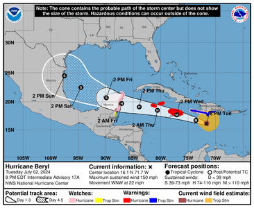
1719974949463.png


000
WTNT32 KNHC 030246
TCPAT2

BULLETIN
Hurricane Beryl Advisory Number 18
NWS National Hurricane Center Miami FL AL022024
1100 PM EDT Tue Jul 02 2024

...DANGEROUS HURRICANE BERYL EXPECTED TO BRING LIFE-THREATENING
WINDS AND STORM SURGE TO JAMAICA ON WEDNESDAY AND THE CAYMAN ISLANDS
WEDNESDAY NIGHT AND THURSDAY...


SUMMARY OF 1100 PM EDT...0300 UTC...INFORMATION
-----------------------------------------------
LOCATION...16.2N 72.7W
ABOUT 300 MI...480 KM ESE OF KINGSTON JAMAICA
MAXIMUM SUSTAINED WINDS...150 MPH...240 KM/H
PRESENT MOVEMENT...WNW OR 290 DEGREES AT 22 MPH...35 KM/H
MINIMUM CENTRAL PRESSURE...947 MB...27.97 INCHES


WATCHES AND WARNINGS
--------------------
CHANGES WITH THIS ADVISORY:

None.

SUMMARY OF WATCHES AND WARNINGS IN EFFECT:

A Hurricane Warning is in effect for...
* Jamaica
* Grand Cayman
* Little Cayman and Cayman Brac

A Hurricane Watch is in effect for...
* South coast of Haiti from the border with the Dominican
Republic to Anse d'Hainault
* East coast of the Yucatan Peninsula from Chetumal to Cabo Catoche

A Tropical Storm Warning is in effect for...
* South coast of Dominican Republic from Punta Palenque westward
to the border with Haiti
* South coast of Haiti from the border with the Dominican
Republic to Anse d'Hainault

A Tropical Storm Watch is in effect for...
Coast of Belize from south of Chetumal to Belize City

A Hurricane Warning means that hurricane conditions are expected
somewhere within the warning area. Preparations to protect life
and property should be rushed to completion.

A Tropical Storm Warning means that tropical storm conditions are
expected somewhere within the warning area within 36 hours.

A Hurricane Watch means that hurricane conditions are possible
within the watch area. A watch is typically issued 48 hours
before the anticipated first occurrence of tropical-storm-force
winds, conditions that make outside preparations difficult or
dangerous.

A Tropical Storm Watch means that tropical storm conditions are
possible within the watch area, generally within 48 hours.

Interests elsewhere in the northwestern Caribbean Sea and the
western Gulf of Mexico should closely monitor the progress of Beryl.

For storm information specific to your area, please monitor
products issued by your national meteorological service.


DISCUSSION AND OUTLOOK
----------------------
At 1100 PM EDT (0300 UTC), the center of Hurricane Beryl was located
near latitude 16.2 North, longitude 72.7 West. Beryl is moving
toward the west-northwest near 22 mph (35 km/h), and this general
motion should continue through Wednesday, followed by a turn more
toward the west Wednesday night or Thursday. On the forecast track,
the center of Beryl will move rapidly across the central Caribbean
Sea tonight and is forecast to pass near or over Jamaica on
Wednesday. The center is expected to pass near or over the Cayman
Islands Wednesday night or early Thursday and approach the Yucatan
Peninsula of Mexico Thursday night.

Maximum sustained winds are near 150 mph (240 km/h) with higher
gusts. Beryl is a category 4 hurricane on the Saffir-Simpson
Hurricane Wind Scale. Weakening is forecast during the next day or
two. However, Beryl is forecast to be at or near major hurricane
intensity while it passes near Jamaica on Wednesday and the Cayman
Islands on Wednesday night. Additional weakening is expected
thereafter, though Beryl is forecast to remain a hurricane in the
northwestern Caribbean.

Hurricane-force winds extend outward up to 40 miles (65 km) from the
center and tropical-storm-force winds extend outward up to 185 miles
(295 km).

The minimum central pressure estimated from Hurricane Hunter
aircraft observations is 947 mb (27.97 inches).


HAZARDS AFFECTING LAND
----------------------
Key messages for Beryl can be found in the Tropical Cyclone
Discussion under AWIPS header MIATCDAT2 and WMO header WTNT42 KNHC.

WIND: Hurricane conditions are expected to reach the coast of
Jamaica within the warning area on Wednesday. Winds are expected to
first reach tropical storm strength early on Wednesday, making
outside preparations difficult or dangerous.

Hurricane conditions are expected to reach the Cayman Islands
Wednesday night or early Thursday. Winds are expected to first
reach tropical storm strength on Wednesday, making outside
preparations difficult or dangerous.

Hurricane conditions are possible along portions of the east coast
of the Yucatan Peninsula by late Thursday.

Tropical storm conditions are expected in the warning area along the
south coast of Hispaniola tonight and early Wednesday.

Tropical storm conditions are possible along portions of the coast
of Belize by late Thursday or early Friday.

STORM SURGE: Storm surge could raise water levels by as much as 6
to 9 feet above normal tide levels in areas of onshore winds along
the immediate coast of Jamaica.

Storm surge could raise water levels by as much as 2 to 4 feet
above normal tide levels in areas of onshore winds along the
immediate coast of the Cayman Islands.

Storm surge could raise water levels by as much as 1 to 3 feet above
ground level in areas of onshore winds along the southern coast of
Hispaniola.

Storm surge could raise water levels by as much as 3 to 5 feet
above ground level in areas of onshore winds along the east coast of
the Yucatan Peninsula within the hurricane watch area.

Near the coast, the surge will be accompanied by large and
destructive waves.

RAINFALL: Hurricane Beryl is expected to produce rainfall totals of
4 to 8 inches, with localized maxima of 12 inches, across Jamaica
and southwestern Haitian Peninsula through late Wednesday. Beryl
will also produce rainfall amounts of 4 to 8 inches with isolated
amounts of 10 inches across Barahona Peninsula in southwest
Dominican Republic. Isolated totals of 6 inches or more are also
anticipated across the mountainous terrain in the central Dominican
Republic. This rainfall is likely to cause flash flooding and
mudslides.

Beryl is also expected to produce rainfall totals of 2 to 4 inches
with localized maxima of 6 inches over the Cayman Islands Wednesday
into Thursday. Over the Yucatan Peninsula into northern Belize,
Beryl is expected to produce rainfall totals of 2 to 4 inches with
localized maxima of 6 inches in the northeastern Yucatan Peninsula
Thursday into Friday.

For a complete depiction of forecast rainfall and flash flooding
associated with Hurricane Beryl, please see the National Weather
Service Storm Total Rainfall Graphic, available at
hurricanes.gov/graphics_at2.shtml?rainqpf

SURF: Large swells generated by Beryl will continue across the
Windward and southern Leeward Islands during the next day or so.
Swells will impact the southern coasts of Puerto Rico and
Hispaniola, and begin affecting Jamaica and the Cayman Islands
through midweek. These swells are expected to cause life-threatening
surf and rip current conditions. Please consult products from your
local weather office.


NEXT ADVISORY
-------------
Next intermediate advisory at 200 AM EDT.
Next complete advisory at 500 AM EDT.

$$
Forecaster Pasch
 
Good morning all.

OK so what i've seen so far...there's still a lot of difference in the models.

Hurricane Hunters are out doing their thing: https://www.tropicaltidbits.com/recon/

GFS has this thing going into Southeast Texas rough estimate July 8 or so. because its not showing the blocking high. Also Texas is on the right side (i.e., dirty side of this storm)

Euro has it going into Mexico at as a much weaker storm and it shows the blocking high.

I'm looking at intensity models and... well its a bit all over the place there too. There's talk about air ingestion which should weaken the storm. Also if the storm goes over land hopeful weakening then too.

Because hurricanes spin counter clockwise, anything on the right side of the storm gets the worst of the storm surge, the storms, and the wind. There also looks to be a smaller storm behind it, I hope its just a computer anomaly but tis the season.

Southwestern Gulf states should be prepared for pretty much anything.

As it is, Jamaica is on the right side of center based on the blended map and thats a bad place to be. Lot of prayers going out to that area its still a very strong storm.

National Hurricane Center blends the models together to come up with an average. This is the reason why you see the cone like it is today and not one model over the other...both could be possible, both could be wrong. And the center of the storm could be on any edge of this cone or in middle, with heavy winds and storm damage well outside of that center.

1720014172703.png


000
WTNT42 KNHC 030854
TCDAT2

Hurricane Beryl Discussion Number 19
NWS National Hurricane Center Miami FL AL022024
500 AM EDT Wed Jul 03 2024

Beryl appears to be experiencing the effects of moderate
northwesterly shear. The eye has become cloud-filled, and the
hurricane's cloud pattern is elongated northeast to southwest.
Still, very deep convection is present in the eyewall and the core
of the hurricane remains intact. Data from an earlier Air Force
Hurricane Hunter aircraft had maximum flight-level winds of 136 kt
and a slightly higher minimum central pressure than the previous
advisory. Therefore, the initial intensity is held at 125 kt,
pending data from the next set of reconnaissance aircraft.

The intensity forecast remains rather challenging. The uncertainty
starts right away due to noticeable discrepancies in the short-term
evolution of the upper-level flow in the global models. The ECMWF
global model predicts strong westerly flow from an upper-level
trough that would significantly increase the shear over Beryl in the
next 24 h and result in rapid weakening. However, the GFS model
shows a very different upper-level wind pattern that would result in
only moderate vertical wind shear near Beryl and thus, less
weakening. The official forecast shows a blend of these solutions
and general weakening through 48 h. It should be emphasized that
Beryl is expected to remain a dangerous hurricane as it passes near
Jamaica in the next 12 h, the Cayman Islands early on Thursday, and
the Yucatan Peninsula on Friday. As Beryl emerges over the warm
waters of the Gulf Mexico in about 72 h, an upper-level ridge is
forecast to build closer to the storm, and more numerical model
guidance is showing restrengthening. The official forecast now
shows Beryl becoming a hurricane before making landfall along the
western coast of the Gulf of Mexico, and lies a bit below the model
consensus.


The hurricane has continued its rapid pace across the central
Caribbean at around 285/17 kt. A strong mid-level ridge centered
over the southeastern US is expected to continue steering Beryl
generally west-northwestward at a decreasing speed for the next
couple of days or so. The core of the hurricane should pass near or
just south of Jamaica later today, with little change to the
forecast near Yucatan. Over the Gulf of Mexico, the storm should
turn northwestward as a trough moving over the central US weakens
the ridge over the weekend. There is still significant uncertainty
in the long-term track forecast, as numerical models showing
stronger storms in the Gulf of Mexico are generally on the northern
side of the guidance envelope and weaker storms on the southern
side. The NHC track forecast lies in the middle of the guidance
envelope, near the multi-model consensus aids and is very similar to
the previous forecast.

Key Messages:

1. Devastating hurricane-force winds, life-threatening storm surge,
and damaging waves are expected in portions of Jamaica beginning
this afternoon and in the Cayman Islands early on Thursday.
Residents in these areas should listen to local government and
emergency management officials for preparedness and/or evacuation
orders.

2. Life-threatening flash flooding and mudslides from heavy rainfall
are expected over much of Jamaica and southern Haiti through today.

3. Beryl is forecast to remain a hurricane when it approaches the
Yucatan Peninsula and Belize late Thursday, where hurricane and
tropical storm watches have been issued.

4. There remains uncertainty in the track and intensity forecast of
Beryl over the western Gulf of Mexico this weekend. Interests in the
western Gulf of Mexico should monitor the progress of Beryl.


FORECAST POSITIONS AND MAX WINDS

INIT 03/0900Z 16.6N 74.4W 125 KT 145 MPH
12H 03/1800Z 17.3N 76.9W 115 KT 130 MPH
24H 04/0600Z 18.1N 80.4W 100 KT 115 MPH
36H 04/1800Z 18.7N 83.8W 90 KT 105 MPH
48H 05/0600Z 19.4N 86.9W 85 KT 100 MPH
60H 05/1800Z 20.1N 89.5W 50 KT 60 MPH...INLAND
72H 06/0600Z 21.1N 91.9W 55 KT 65 MPH...OVER WATER
96H 07/0600Z 23.0N 95.5W 65 KT 75 MPH
120H 08/0600Z 25.0N 98.0W 60 KT 70 MPH...INLAND

$$
Forecaster Bucci/Blake
 
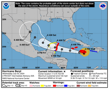
Good afternoon, unfortunately Jamaica is feeling the brunt of Beryl now.

This storm has been very destructive in the island chain and its got a very large wind field a little scary actually.


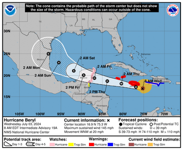
1720029848314.png
Public advisory

000
WTNT32 KNHC 031741
TCPAT2

BULLETIN
Hurricane Beryl Intermediate Advisory Number 20A
NWS National Hurricane Center Miami FL AL022024
200 PM EDT Wed Jul 03 2024

...HURRICANE CONDITIONS ABOUT TO SPREAD INTO JAMAICA AS THE EYE OF
BERYL APPROACHES...
...EYE OF BERYL EXPECTED TO APPROACH THE CAYMAN ISLANDS TONIGHT
INTO THURSDAY...


SUMMARY OF 200 PM EDT...1800 UTC...INFORMATION
----------------------------------------------
LOCATION...17.3N 76.9W
ABOUT 45 MI...70 KM S OF KINGSTON JAMAICA
ABOUT 320 MI...515 KM ESE OF GRAND CAYMAN
MAXIMUM SUSTAINED WINDS...140 MPH...225 KM/H
PRESENT MOVEMENT...WNW OR 285 DEGREES AT 18 MPH...30 KM/H
MINIMUM CENTRAL PRESSURE...959 MB...28.32 INCHES


WATCHES AND WARNINGS
--------------------
CHANGES WITH THIS ADVISORY:

None.

SUMMARY OF WATCHES AND WARNINGS IN EFFECT:

A Hurricane Warning is in effect for...
* Jamaica
* Grand Cayman
* Little Cayman and Cayman Brac
* The coast of the Yucatan Peninsula of Mexico from Puerto Costa
Maya to Cancun

A Hurricane Watch is in effect for...
* The coast of the Yucatan Peninsula of Mexico south of Puerto
Costa Maya to Chetumal
* The coast of the Yucatan Peninsula of Mexico north of Cancun to
Cabo Catoche

A Tropical Storm Warning is in effect for...
* South coast of Haiti from the border with the Dominican
Republic to Anse d'Hainault
* The coast of the Yucatan Peninsula of Mexico south of Puerto
Costa Maya to Chetumal
* The coast of the Yucatan Peninsula of Mexico north of Cancun to
Cabo Catoche

A Tropical Storm Watch is in effect for...
* Coast of Belize from south of Chetumal to Belize City
* The coast of the Yucatan Peninsula of Mexico west of Cabo
Catoche to Campeche

A Hurricane Warning means that hurricane conditions are expected
somewhere within the warning area. Preparations to protect life
and property should be rushed to completion.

A Tropical Storm Warning means that tropical storm conditions are
expected somewhere within the warning area within 36 hours.

A Hurricane Watch means that hurricane conditions are possible
within the watch area, generally within 48 hours.

A Tropical Storm Watch means that tropical storm conditions are
possible within the watch area, generally within 48 hours.

Interests elsewhere in the northwestern Caribbean Sea and the
western Gulf of Mexico, including southern Texas, should closely
monitor the progress of Beryl.

For storm information specific to your area, please monitor
products issued by your national meteorological service.


DISCUSSION AND OUTLOOK
----------------------
At 200 PM EDT (1800 UTC), the center of Hurricane Beryl was located
near latitude 17.3 North, longitude 76.9 West. Beryl is moving
toward the west-northwest near 18 mph (30 km/h), and this general
motion should continue through today, followed by a turn more toward
the west tonight or Thursday. On the forecast track, the center of
Beryl will pass near or over Jamaica during the next several hours.
After that, the center is expected to pass near or over the Cayman
Islands tonight or early Thursday and move over the Yucatan
Peninsula of Mexico Thursday night or early Friday.

Maximum sustained winds are near 140 mph (225 km/h) with higher
gusts. Beryl is a category 4 hurricane on the Saffir-Simpson
Hurricane Wind Scale. Some weakening is forecast during the next
day or two. However, Beryl is forecast to be at or near major
hurricane intensity while it passes near Jamaica during the next
several hours and the Cayman Islands tonight or early Thursday.

Additional weakening is expected thereafter, though Beryl is
forecast to remain a hurricane in the northwestern Caribbean.

Hurricane-force winds extend outward up to 45 miles (75 km) from
the center and tropical-storm-force winds extend outward up to 185
miles (295 km).

The latest minimum central pressure estimated from Air Force
Reserve Hurricane Hunter aircraft data is 959 mb (28.32 inches).


HAZARDS AFFECTING LAND
----------------------
Key messages for Beryl can be found in the Tropical Cyclone
Discussion under AWIPS header MIATCDAT2 and WMO header WTNT42 KNHC.

WIND: Hurricane conditions are about to spread into Jamaica,
especially along the southern coast and in the mountainous areas.
Tropical storm conditions are spreading across Jamaica at this time,
making outside preparations difficult or dangerous.

Wind speeds atop and on the windward sides of hills and mountains
are often up to 30 percent stronger than the near-surface winds
indicated in this advisory, and in some elevated locations could be
even greater.

Hurricane conditions are expected to reach the Cayman Islands
tonight or early Thursday. Winds are expected to first reach
tropical storm strength late this afternoon, making outside
preparations difficult or dangerous.

Hurricane conditions are expected in the hurricane warning area on
the Yucatan Peninsula Thursday night or early Friday morning. Winds
are expected to first reach tropical storm strength by late
Thursday, making outside preparations difficult or dangerous.

Hurricane conditions are possible in the hurricane watch area
along the east coast of the Yucatan Peninsula as early as late
Thursday.

Tropical storm conditions are expected in the tropical storm warning
area along the southwestern peninsula of Haiti today, and in the
tropical storm warning area of the Yucatan Peninsula by late
Thursday.

Tropical storm conditions are possible in the tropical storm
watch area along portions of the coast of Belize by late Thursday
or early Friday, and in the tropical storm watch area along the
coast of the Yucatan Peninsula by Friday or Friday night.

STORM SURGE: Storm surge could raise water levels by as much as 6
to 9 feet above normal tide levels in areas of onshore winds along
the immediate coast of Jamaica.

Storm surge could raise water levels by as much as 2 to 4 feet above
normal tide levels in areas of onshore winds along the immediate
coast of the Cayman Islands.

Storm surge could raise water levels by as much as 1 to 3 feet above
ground level in areas of onshore winds along the southern coast of
Hispaniola.

Storm surge could raise water levels by as much as 3 to 5 feet
above ground level in areas of onshore winds along the east coast of
the Yucatan Peninsula within the hurricane warning area.

Near the coast, the surge will be accompanied by large and
destructive waves.

RAINFALL: Beryl is expected to produce rainfall totals of 4 to 8
inches with localized amounts of 12 inches across Jamaica through
this evening, along with additional rainfall of 4 to 6 inches
over the Tiburon Peninsula of Haiti. This heavy rainfall is expected
to cause life-threatening flash flooding and mudslides.

Beryl is also expected to bring rainfall totals of 4 to 6 inches
over the Cayman Islands tonight into Thursday. Over the Yucatan
Peninsula into northern Belize, Beryl is expected to produce
rainfall totals of 4 to 6 inches with localized amounts of 8 inches
late Thursday through Friday. Scattered instances of flash flooding
are anticipated.

For a complete depiction of forecast rainfall and flash flooding
associated with Hurricane Beryl, please see the National Weather
Service Storm Total Rainfall Graphic, available at
hurricanes.gov/graphics_at2.shtml?rainqpf

SURF: Large swells generated by Beryl are impacting the southern
coasts of Puerto Rico, Hispaniola, and Jamaica, and are expected to
impact the Cayman Islands, the northern coast of Nicaragua, and the
coast of Honduras later today. Swells will also spread toward
portions of western Cuba, the Yucatan Peninsula, and the coast of
Belize during the next day or so. These swells are expected to
cause life-threatening surf and rip current conditions. Please
consult products from your local weather office.


NEXT ADVISORY
-------------
Next complete advisory at 500 PM EDT.

$$
Forecaster Beven
 
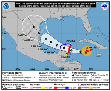
Beryl is still passing The Cayman Islands with a really big wind field.
Models are closer to agreement than before and looks like South Texas, Northern Mexico where the eye will come ashore.


1720097111178.png


000
WTNT42 KNHC 040856
TCDAT2

Hurricane Beryl Discussion Number 23
NWS National Hurricane Center Miami FL AL022024
500 AM EDT Thu Jul 04 2024

Satellite images indicate that Beryl continues to have a large area
of strong convection near the center, although the overall cloud
pattern has become less symmetric. This matches the radar imagery
from Grand Cayman which shows a well-defined eyewall on the
northern side but remains open on the southern side. There isn't
much reason to believe that the gradual filling seen in the last
aircraft mission has stopped, and the initial wind speed is set to
105 kt, a bit lower than what the last aircraft data supported.
The NOAA and Air Force Hurricane Hunters should be in the cyclone
within a few hours for a better intensity estimate.


Beryl appears to be moving west-northwestward or 285/17 kt.
Overall, there are no significant changes to the track forecast. A
large ridge centered over the southeastern U.S. should cause Beryl
to move westward or west-northwestward during the next couple of
days.
Model guidance is tightly clustered on a course toward the
Yucatan Peninsula early Friday and emerging into the southern Gulf
of Mexico early Saturday. The western periphery of the ridge is
forecast to weaken due to a series of shortwaves moving over the
Central Plains, causing Beryl to slow down and turn northwestward
this weekend. While there isn't an atypical amount of track spread
by the time Beryl impacts the western Gulf Coast early next week,
the average error at day 4 is about 150 miles, so it is too early to
pinpoint a specific region for the worst hazards.
The new NHC
forecast is close to the model consensus and the previous forecast.

Water vapor images show a upper-level trough moving west-
southwestward over the southern Gulf of Mexico, helping to impart
moderate-to-strong shear over Beryl. While the hurricane has been
an over-performer so far, this magnitude of shear should cause
notable weakening over the next day or so, but Beryl is expected to
still be a hurricane near the Yucatan tomorrow. After emerging into
the Gulf of Mexico, Beryl will likely have a couple of days to
re-strengthen over warm waters with light or moderate shear. Almost
all of the model guidance show the system near hurricane strength as
Beryl approaches the western Gulf Coast, and so does the official
forecast. The NHC intensity forecast is basically the same as the
previous one, but should be considered of low confidence due to the
inherent uncertainties of intensity forecasts in moderate shear.


Key Messages:

1. Strong winds, dangerous storm surge, damaging waves, and areas of
flooding are expected to occur in the Cayman Islands today where a
Hurricane Warning remains in effect.

2. Hurricane-force winds, dangerous storm surge, and heavy rainfall
are expected over portions of the Yucatan Peninsula and Belize
beginning tonight as Beryl approaches that area as a hurricane.
Hurricane and Tropical Storm Warnings are now in effect
for portions of that area.

3. There remains uncertainty in the track and intensity forecast of
Beryl over the western Gulf of Mexico this weekend. Interests in
eastern Mexico and southern Texas should monitor the progress of
Beryl. Regardless of the exact track, rip currents could cause
life-threatening beach conditions beginning late Friday and
continuing through the weekend across much of the Gulf coast.


FORECAST POSITIONS AND MAX WINDS

INIT 04/0900Z 18.5N 81.0W 105 KT 120 MPH
12H 04/1800Z 19.0N 83.6W 95 KT 110 MPH
24H 05/0600Z 19.5N 86.7W 80 KT 90 MPH
36H 05/1800Z 20.3N 89.2W 50 KT 60 MPH...INLAND
48H 06/0600Z 21.2N 91.5W 50 KT 60 MPH...OVER WATER
60H 06/1800Z 22.3N 93.6W 55 KT 65 MPH
72H 07/0600Z 23.3N 95.3W 60 KT 70 MPH
96H 08/0600Z 25.2N 97.6W 65 KT 75 MPH...NEAR COAST
120H 09/0600Z 27.0N 99.3W 35 KT 40 MPH...INLAND

$$
Forecaster Blake
 
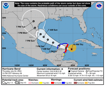
Beryl is back to a cat 3 There is a lot of model consensus on where it will go, same place I was talking about but now its a matter of how strong will it be.

This damn thing (xcuse my french) has been absolutely cray to pin down. Definitely hurricane hunters jobs are vital to bringing back good data, but it does go to show how some storms like this are really their own thing once they become big enough.


000
WTNT62 KNHC 050129
TCUAT2

Hurricane Beryl Tropical Cyclone Update
NWS National Hurricane Center Miami FL AL022024
930 PM EDT Thu Jul 4 2024

...BERYL STRENGTHENS BACK TO A CATEGORY 3 HURRICANE AS IT NEARS THE
YUCATAN PENINSULA...

Data from the Air Force reconnaissance aircraft indicate that Beryl
has strengthened to a category 3 hurricane with maximum winds of
115 mph (185 km/h). The aircraft data also indicated that the
minimum pressure has fallen to 962 mb.

The next forecast will be issued at the normally scheduled time at
11 PM EDT (0300 UTC).

SUMMARY OF 930 PM AST...0130 UTC...INFORMATION
-----------------------------------------------
LOCATION...19.6N 85.1W
ABOUT 160 MI...260 KM ESE OF TULUM MEXICO
MAXIMUM SUSTAINED WINDS...115 MPH...185 KM/H
PRESENT MOVEMENT...W OR 275 DEGREES AT 16 MPH...26 KM/H
MINIMUM CENTRAL PRESSURE...962 MB...28.41 INCHES

$$
Forecaster Cangialosi/Hagen
 
1720148306104.png

000
WTNT42 KNHC 050245
TCDAT2

Hurricane Beryl Discussion Number 26
NWS National Hurricane Center Miami FL AL022024
1000 PM CDT Thu Jul 04 2024

The weakening trend of Beryl has reversed this evening. Satellite
images show that the eye has occasionally been evident and the
eyewall is about two-thirds closed based on Cancun radar images and
reports from the Air Force Hurricane Hunters. Data from the
reconnaissance mission indicated that Beryl has strengthened back to
a dangerous category 3 hurricane with maximum winds of about 100 kt.
The minimum pressure has fallen about 10 mb from this afternoon to
964 mb. The aircraft also indicated that Beryl remains compact, and
it is actually a little smaller than previously estimated.


The hurricane has turned westward and slowed down slightly on the
south side of a ridge centered over the southeastern U.S., with the
latest initial motion estimated to be 275/14 kt. Beryl is expected
to maintain that general motion during the next 12 hours, which
should cause it to make landfall in the Yucatan Peninsula very near
Tulum early Friday morning. Most of the models show the center
remaining over land for about 18 hours, and then emerging over the
southwestern Gulf of Mexico Friday night. Around that time, Beryl
is expected to turn to the northwest and slow down some more as it
moves along the western periphery of the weakening ridge and toward
a trough over the south-central U.S. Although the models are in
fair agreement, there is still some spread in exactly how sharp the
system turns northwestward, and to a large degree the structure and
intensity of Beryl will be a notable factor on its track over the
Gulf.
The new NHC track forecast is a little slower than the
previous one, following the trend in the latest models.

It now seems likely that Beryl will maintain its strength until it
reaches the coast. Once the core moves inland, rapid weakening is
expected, and Beryl is forecast to fall below hurricane strength by
the time it exits the Yucatan. Assuming the system is able to
maintain some elements of an inner core, gradual re-intensification
seems likely before it makes its final landfall in northeastern
Mexico or southern Texas. The NHC intensity forecast again lies
near the high end of the models and continues to show Beryl becoming
a hurricane again over the western Gulf.

Users are reminded that the average NHC track error at day 3 is
around 100 miles, so it is too soon to pinpoint where the largest
impacts will be.


Key Messages:

1. Hurricane-force winds, dangerous storm surge, and heavy rainfall
are forecast to begin within the next few hours across the Yucatan
Peninsula within the hurricane warning area. Residents there should
shelter in place through the passage of these life-threatening
conditions.

2. There is an increasing risk of strong winds, storm surge, and
heavy rainfall in portions of northeastern Mexico and southern Texas
late this weekend. Interests in these areas should closely monitor
the progress of Beryl and updates to the forecast. Hurricane and
Tropical Storm Watches will likely be issued on Friday.

3. Rip currents could cause life-threatening beach conditions
beginning late Friday and continuing through the weekend across much
of the Gulf coast.


FORECAST POSITIONS AND MAX WINDS

INIT 05/0300Z 19.6N 85.5W 100 KT 115 MPH
12H 05/1200Z 20.0N 87.5W 95 KT 110 MPH...INLAND
24H 06/0000Z 20.9N 89.9W 55 KT 65 MPH...INLAND
36H 06/1200Z 21.9N 92.1W 55 KT 65 MPH...OVER WATER
48H 07/0000Z 22.9N 94.0W 60 KT 70 MPH
60H 07/1200Z 23.8N 95.5W 65 KT 75 MPH
72H 08/0000Z 24.7N 96.6W 70 KT 80 MPH
96H 09/0000Z 26.8N 98.6W 45 KT 50 MPH...INLAND
120H 10/0000Z 28.9N 99.1W 25 KT 30 MPH...INLAND

$$
Forecaster Cangialosi
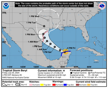
 
So far the updates:
Beryl is over the Yucatan and they've changed things a little bit because its hitting further off the coast. I've heard that some of the resorts have people moving to more secure buildings (which is good) There is a lot of destruction with this storm though, and because there are some deaths associated it will be a name thats retired.

Based on models I'm seeing, it looks like the eye comes ashore in Texas. How far down? Well, basically they had it mostly to Brownsville but looks to be higher.

So Texas needs to be prepped for whatever comes through there. If it crosses the gulf and gets strong again quickly, its gonna be a mess. The intensity models are what keep everyone guessing.


Next Advisory is 10amCDT I'll post it when it comes out.
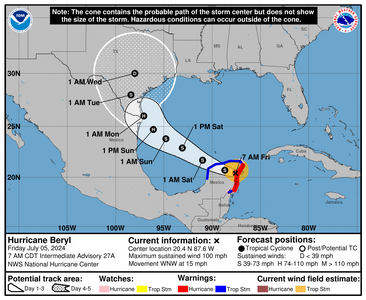
1720183233564.png
 
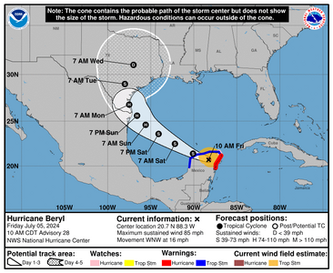
Texas, Texas, Texas. As this thing comes off the Yucatan, please play very close attention. That high that was supposed to be there is not there. I'm hoping that there's no strengthening when it comes of the Peninsula but the water is hot enough and the storm will be over it at least 2 days. Thats enough for it to intensify. There's a chance it just stays a sloppy mess..certain things can be unpredicable, but according to the modeling and this storms history thats not looking too likely.

Once the storm is over the water recon missions will continue.

Upgraded track has the storm moving northwesterly coming off the Yucatan. The entire Gulf coast of Texas is in play here because it could well ride the coast.

1720192720465.png
00
WTNT42 KNHC 051451
TCDAT2

Hurricane Beryl Discussion Number 28
NWS National Hurricane Center Miami FL AL022024
1000 AM CDT Fri Jul 05 2024

The center of Beryl made landfall on the Yucatan Peninsula of
Mexico just northeast of Tulum at about 11Z. The landfall intensity
is somewhat uncertain, but surface observations suggest the central
pressure rose into the 977-980 mb range before landfall. The
cyclone is now weakening as it moves farther inland, and the
initial intensity is reduced to 75 kt.

The initial motion is now 290/14 kt. For the next 24 h or so,
Beryl should be steered generally west-northwestward by the
western portion of the subtropical ridge over the southeastern
United States. After that, a turn toward the northwest is likely
as the storm moves towards a break in the ridge caused by a
combination of a trough in the mid-latitude westerlies over the
central United States and an upper-level trough moving westward
over the southwestern Gulf of Mexico. This motion should bring the
center near the western Gulf coast in about 72 h. Subsequently, a
northward motion through the break appears likely. While the track
guidance has come into better agreement, there is still uncertainty
based on the possible strength and vertical depth of Beryl. A
stronger and vertically deeper cyclone would feel more steering
from upper-level southwesterly flow caused by the Gulf trough, and
thus would have a more northward motion, while a weaker system
would probably continue more northwestward. Overall the guidance
favors the more northward motion and has shifted a little to the
right, and the new official forecast also is nudged a little to the
right of the previous forecast. Additional adjustments of the
forecast track could be necessary later today.


Beryl should continue to weaken while over land, and it is expected
to emerge over the Gulf of Mexico as a tropical storm. After that,
it could take 12-24 h for the cyclone's structure to recover over
the Gulf of Mexico before re-intensification can begin in earnest.
Based on this and the overall trends of the intensity guidance, the
new forecast calls for gradual strengthening to start after 24 h
and continue until landfall. One important note is that the GFS
and ECMWF suggest that ongoing westerly shear could decrease after
48-60 h, accompanied by an increase in upper-level divergence.
Should this occur, Beryl could strengthen more than currently
forecast, especially if the center stays over water longer than
forecast.


Users are reminded that the average NHC track error at day 3 is
around 100 miles, and it remains too soon to pinpoint where the
greatest impacts will be. However, watches for portions of
northeastern Mexico and South Texas will likely be required later
today.


Key Messages:

1. Dangerous winds, storm surge, and heavy rainfall will continue
over portions of the Yucatan Peninsula within the warning areas
today. Residents there should shelter in place until these
life-threatening conditions subside.

2. There is an increasing risk of hurricane-force winds,
life-threatening storm surge, and flooding from heavy rainfall in
portions of northeastern Mexico and the lower and middle Texas coast
late Sunday and Monday. Interests in these areas should closely
monitor updates to the forecast. Storm Surge, Hurricane and
Tropical Storm Watches will likely be issued later today.

3. Rip currents will cause life-threatening beach conditions
beginning late today and continuing through the weekend across much
of the Gulf coast. Beachgoers should heed warning flags and the
advice of lifeguards and local officials before venturing into the
water.


FORECAST POSITIONS AND MAX WINDS

INIT 05/1500Z 20.7N 88.3W 75 KT 85 MPH...INLAND
12H 06/0000Z 21.4N 90.1W 55 KT 65 MPH...OVER WATER
24H 06/1200Z 22.5N 92.2W 55 KT 65 MPH
36H 07/0000Z 23.6N 94.1W 60 KT 70 MPH
48H 07/1200Z 24.6N 95.6W 65 KT 75 MPH
60H 08/0000Z 25.6N 96.6W 70 KT 80 MPH
72H 08/1200Z 26.8N 97.5W 75 KT 85 MPH...NEAR COAST
96H 09/1200Z 29.0N 98.0W 35 KT 40 MPH...INLAND
120H 10/1200Z 31.0N 97.0W 25 KT 30 MPH...INLAND

$$
Forecaster Beven
 
Warnings are up on the Texas Coastline. The expected weakening has happened, but its a matter of how quickly this storm reorganizes. Basically NHC is calling it a Cat 1 possible 2 which is still significant.

I'm hoping our Texas Pricescopers in the path are well prepared for this.
1720218617783.png


732
WTNT42 KNHC 052045
TCDAT2

Tropical Storm Beryl Discussion Number 29
NWS National Hurricane Center Miami FL AL022024
400 PM CDT Fri Jul 05 2024

Beryl has weakened below hurricane strength while crossing the
northern portion of the Yucatan Peninsula. Satellite imagery shows
that the cloud tops in the central convection have warmed except
for one small area just northeast of the center, and radar data
from Cancun shows that the rainbands near the center have become
less organized. The initial intensity is reduced to a somewhat
uncertain 55 kt, as there is little in the way of wind data from the
inner core.

The initial motion is now 295/13 kt. There is little change in
the philosophy or the meteorology of the track forecast. For the
next 12 h or so, Beryl should be steered generally
west-northwestward by the western portion of the subtropical ridge
over the southeastern United States. After that, a turn toward the
northwest is likely as the storm moves towards a break in the ridge
caused by a combination of a trough in the mid-latitude westerlies
over the central United States and an upper-level trough moving
westward over the southwestern Gulf of Mexico. This motion should
bring the center near the western Gulf coast in about 72 h.
Subsequently, a northward motion through the break appears likely.
The track guidance has shifted eastward since the previous advisory,
with the most notable change being the ECMWF model, which is now on
the eastern side of the guidance envelope. The new forecast track
is shifted east of the previous track, but it still lies to the
west of the various consensus models. Therefore, additional
adjustments of the forecast track could be necessary tonight.

Beryl will likely weaken a little more before the center emerges
over the Gulf of Mexico this evening. After that, it could take
12-24 h for the cyclone's structure to recover over the Gulf of
Mexico before re-intensification begins in earnest, and during
this time the large-scale models suggest continued southwesterly
shear. Based on this and the overall trend of the intensity
guidance, the new forecast calls for gradual strengthening to start
around 24 h, and the first part of this forecast could be a bit
generous. However, the upper-level winds become more favorable as
the cyclone approaches the western Gulf coast after 36 h, with
decreasing shear and increasing upper-level divergence. This
combination should allow a faster rate of strengthening. The new
intensity forecast now calls for an 80-kt intensity at landfall in
best agreement with the HWRF, HAFS-B, and HMON models, and this
could be conservative if Beryl stays over water longer than
currently forecast.

Users are reminded that the average NHC track error at day 3 is
around 100 miles, and it remains too soon to pinpoint where the
greatest impacts will be.


Key Messages:

1. There is an increasing risk of damaging hurricane-force winds and
life-threatening storm surge in portions of northeastern Mexico and
the lower and middle Texas Coast late Sunday and Monday where
Hurricane and Storm Surge Watches have been issued. Additional
watches may be required tonight or early Saturday. Interests in
these areas should follow any advice given by local officials.

2. Flash and urban flooding are possible across portions of the
Texas Gulf Coast and eastern Texas from Sunday through the middle of
next week.

3. Rip currents will cause life-threatening beach conditions through
the weekend across much of the Gulf Coast. Beachgoers should heed
warning flags and the advice of lifeguards and local officials
before venturing into the water.

4. Strong winds, storm surge, and heavy rainfall will continue over
northern portions of the Yucatan Peninsula this evening.


FORECAST POSITIONS AND MAX WINDS

INIT 05/2100Z 21.2N 89.2W 55 KT 65 MPH...INLAND
12H 06/0600Z 22.0N 91.0W 50 KT 60 MPH...OVER WATER
24H 06/1800Z 23.2N 93.0W 55 KT 65 MPH
36H 07/0600Z 24.3N 94.6W 60 KT 70 MPH
48H 07/1800Z 25.3N 95.9W 65 KT 75 MPH
60H 08/0600Z 26.5N 96.8W 70 KT 80 MPH
72H 08/1800Z 27.8N 97.3W 80 KT 90 MPH...AT COAST
96H 09/1800Z 30.5N 97.0W 30 KT 35 MPH...INLAND
120H 10/1800Z 32.5N 95.5W 25 KT 30 MPH...POST-TROP/INLAND

$$
 
Last edited:
The track was updated I believe yesterday. Now its just a wait and see on intensity. Somethings coming, but most are thinking its still going to be a hurricane as its going to be over water a couple of days. Thought is that it will take time to reorganize as its got to deal with shear.

1720272610241.png
 
1720321837007.png


000
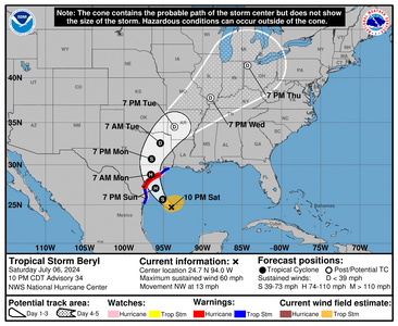
WTNT42 KNHC 070244
TCDAT2

Tropical Storm Beryl Discussion Number 34
NWS National Hurricane Center Miami FL AL022024
1000 PM CDT Sat Jul 06 2024

Beryl has not changed much over the past few hours. Satellite
images still show that the storm has a compact central dense
overcast pattern, and radar and dropsonde data from the NOAA
aircraft indicate that the circulation remains tilted to the
northwest with height. Both the NOAA and Air Force Hurricane Hunter
aircraft have reported a slight drop in minimum pressure to 993 mb,
but the flight-level wind data suggest that the initial intensity is
still around 50 kt.


The storm is moving northwestward at 11 kt on the western periphery
of a mid-level ridge. A turn to the north-northwest with a slight
decrease in forward speed is expected as the system moves toward a
trough over the south-central U.S., taking the core of Beryl to the
middle Texas coast early Monday morning. The shifts in the models
have been decreasing, and the new NHC track forecast is just a touch
to the right of the previous one through landfall. After landfall,
a faster motion to the north and northeast is predicted.


Beryl is currently in an environment of about 10 to 15 kt of
southerly vertical wind shear and surrounded by dry air, especially
on the south side of the circulation. However, the storm is expected
to move into an area of decreasing wind shear, and the global models
show the moisture increasing near the core. In fact, the SHIPS
model shows the shear decreasing to very low levels (less than 5 kt)
just prior to Beryl reaching the coast. These conditions combined
with a diffluent upper-level wind pattern should support notable
strengthening just prior to landfall.
In fact, the hurricane
regional models HAFS-A, HAFS-B, HWRF, and HMON all show only gradual
strengthening during the next 12-24 hours, followed by significant
intensification just hours before Beryl makes landfall. Based on
the guidance and large-scale factors, there is a chance of rapid
intensification if Beryl becomes better vertically aligned, and it
is possible that it strengthens more between the 24- and 36-h
predictions.

It is important to note that the average NHC track error at 36
hours is about 50-60 miles and the average intensity error is close
to one category.
Users are reminded to consider these uncertainties
when using the forecast information.


Key Messages:

1. There is a danger of life-threatening storm surge inundation
late Sunday night and Monday along the coast of Texas from the north
entrance to the Padre Island National Seashore to High Island,
including Corpus Christi Bay, Matagorda Bay, and Galveston Bay.
Residents in those areas should follow any advice given by local
officials and follow evacuation orders.

2. Beryl is forecast to bring damaging hurricane-force winds to
portions of the lower and middle Texas coast late Sunday night and
Monday. A Hurricane Warning is in effect from Baffin Bay to Sargent.
Preparations should be rushed to completion before tropical storm
conditions begin late Sunday.

3. Flash and urban flooding, some of which may be locally
considerable, is likely across portions of the Texas Gulf Coast and
eastern Texas beginning late Sunday through the middle of next week.
River flooding is also possible.

4. Rip currents will cause life-threatening beach conditions through
Monday across much of the Gulf Coast. Beachgoers should heed
warning flags and the advice of lifeguards and local officials
before venturing into the water.


FORECAST POSITIONS AND MAX WINDS

INIT 07/0300Z 24.7N 94.0W 50 KT 60 MPH
12H 07/1200Z 25.7N 95.1W 60 KT 70 MPH
24H 08/0000Z 27.1N 96.0W 75 KT 85 MPH
36H 08/1200Z 28.8N 96.6W 75 KT 85 MPH...INLAND
48H 09/0000Z 30.7N 96.5W 40 KT 45 MPH...INLAND
60H 09/1200Z 32.6N 95.4W 30 KT 35 MPH...INLAND
72H 10/0000Z 34.5N 93.6W 20 KT 25 MPH...POST-TROP/INLAND
96H 11/0000Z 37.8N 89.0W 20 KT 25 MPH...POST-TROP/INLAND
120H 12/0000Z 41.3N 84.3W 20 KT 25 MPH...POST-TROP/INLAND

$$
Forecaster Cangialosi
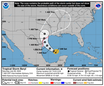
 
I hate hurricanes. I hate storms. That's all I wanted to say. That and stay safe everyone!
 
The good: not intensified beyond a Tropical storm. The bad is that they're saying it still could. Lets hope not! It also looks to be coming ashore at night which is never ideal.
Destruction doesn't stop at landfall, it can be felt inland too with all the rain this will bring as the bigger risks can become flash flooding.

1720357565973.png


A more complete advisory is at 10AM CDT /11AM EDT
 
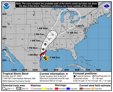
Hopefully those in the path (before and after impact) have emergency plans in place or are working to get them completed. At this point the track is set, its all about how much will this thing ramp up in intensity. There may be another recon mission to determine the intensity and if so I will update this thread. Otherwise I won't.

1720365986165.png


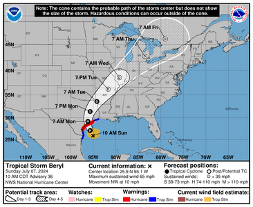
023
WTNT42 KNHC 071448
TCDAT2

Tropical Storm Beryl Discussion Number 36
NWS National Hurricane Center Miami FL AL022024
1000 AM CDT Sun Jul 07 2024

Beryl has become better organized this morning. Satellite images
show deep convection becoming more symmetric around the center, and
Brownsville radar has been showing an eyewall forming, although
still open on the northwest side. An Air Force Reserve Hurricane
Hunter aircraft recently reported maximum flight-level winds of 62
kt with the central pressure falling to 992 mb, so the initial wind
speed is raised to 55 kt.


Further intensification is likely as Beryl moves over very warm
waters within light shear conditions. Rapid intensification is a
distinct possibility if the core can become isolated from the dry
air that has been inhibiting intensification during the last day or
so. While there are no changes to the intensity forecast based on
the latest guidance, we are expecting Beryl to be intensifying up
until landfall early Monday, and people should be preparing for the
possibility of a category 2 hurricane landfall.


Beryl continues to move northwestward at 9 kt. The storm
should turn north-northwest this afternoon and make landfall
along the middle Texas coast early on Monday. The new forecast
is very close to the previous one, just a shade to the east. After
Beryl moves inland, the latest guidance still shows the system
accelerating farther northeastward and become a post-tropical
cyclone. This should bring the threat of flash flooding well into
Missouri.


Key Messages:

1. There is a danger of life-threatening storm surge inundation
along the coast of Texas from the north entrance to the Padre Island
National Seashore to Sabine Pass, including Matagorda Bay and
Galveston Bay. Residents in those areas should follow any advice
given by local officials and follow evacuation orders.

2. Beryl is forecast to bring damaging hurricane-force winds to
portions of the Texas coast tonight and early Monday. A Hurricane
Warning is in effect from Baffin Bay to San Luis Pass. Preparations
should be rushed to completion before tropical storm conditions
begin late today.

3. Flash and urban flooding, some of which may be locally
considerable, is expected across portions of the middle and upper
Texas Gulf Coast and eastern Texas today through Monday night.
River flooding is also expected.

4. Rip currents will cause life-threatening beach conditions through
Monday across much of the Gulf Coast. Beachgoers should heed warning
flags and the advice of lifeguards and local officials before
venturing into the water.


FORECAST POSITIONS AND MAX WINDS

INIT 07/1500Z 25.9N 95.1W 55 KT 65 MPH
12H 08/0000Z 27.1N 95.7W 65 KT 75 MPH
24H 08/1200Z 29.2N 96.2W 75 KT 85 MPH...INLAND
36H 09/0000Z 31.4N 95.7W 35 KT 40 MPH...INLAND
48H 09/1200Z 33.6N 94.2W 25 KT 30 MPH...INLAND
60H 10/0000Z 36.2N 91.7W 25 KT 30 MPH...POST-TROP/INLAND
72H 10/1200Z 38.6N 89.2W 20 KT 25 MPH...POST-TROP/INLAND
96H 11/1200Z 42.8N 83.6W 20 KT 25 MPH...POST-TROP/INLAND
120H 12/1200Z 46.0N 79.0W 20 KT 25 MPH...POST-TROP/INLAND

$$
Forecaster Blake
 
So I'm not going to post any updates because this is all real time with the storm coming ashore and its moving quite slow (which is never good). But there are a lot of power outages. Saying prayer for those in the path, it went more east than many expected.

https://poweroutage.us/area/state/texas

I have members of my team which I can't get ahold of (and thats very scary) but not unexpected.
 
Thanks for keeping us updated @Arcadian - I've been following because dh was suppposed to go to Houston on business. The trip has been cancelled.
 
Thanks for keeping us updated @Arcadian - I've been following because dh was suppposed to go to Houston on business. The trip has been cancelled.
I'm glad he's not there because some parts of Houston metro are not in a good way. Even though its said to have come in as a Cat 1 I do wonder if it will be reclassified.
 
Waiting to hear from family in Houston about their office buildings and homes as well as family property in Rockport.
 
One of my compounding pharmacies is in Houston and they have closed for the past two days...keeping good thoughts for everyone affected...stay safe.
@Matata I hope your family is safe and their homes and property are OK
 
Beryl has been an absolute doozy. I’m in southern IN and we got a ton of rain last night which was the remnants from Beryl. We’re also in tornado alley and there was a watch all day and into the night yesterday, so everyone was bracing for the worst.

We are still cleaning up trees all over town from a freak storm that knocked out power for 3 days. We are a Tree City so you can imagine the impact. My mother wanted us to come down and stay with her but I could not get out of town due to all the downed power lines and trees in the roads in every direction. Still waiting for Duke to send another crew out to repair the lines that are hanging precariously low at the entrance to my community. I think they better hire more linemen; they seem to be spread thin this season with all this crazy weather!
 
The unfortunate part of this @monarch64 is it shows how fragile the electrical grid really is to the elements. Every hurricane or bad weather event shows this.

There's more to say about barrier islands and how overly inhabited they are but that might be a post for another day.
 
Beryl has been an absolute doozy. I’m in southern IN and we got a ton of rain last night which was the remnants from Beryl. We’re also in tornado alley and there was a watch all day and into the night yesterday, so everyone was bracing for the worst.

We are still cleaning up trees all over town from a freak storm that knocked out power for 3 days. We are a Tree City so you can imagine the impact. My mother wanted us to come down and stay with her but I could not get out of town due to all the downed power lines and trees in the roads in every direction. Still waiting for Duke to send another crew out to repair the lines that are hanging precariously low at the entrance to my community. I think they better hire more linemen; they seem to be spread thin this season with all this crazy weather!

Same in west central/southwestern Ohio. We were moving important papers/items to under the basement stairs again just in case - something that used to happen infrequently until about 6-7 years ago. Now it happens multiple times a season, and more with each passing year.
 
Thankfully we weren’t affected in any major way, other than the whole internet system going down across Texas for 7-8 hours. We’re pretty far inland and from what I read, it seems Houston and immediate surrounding areas, were the worst affected areas.
 
GET 3 FREE HCA RESULTS JOIN THE FORUM. ASK FOR HELP
Top